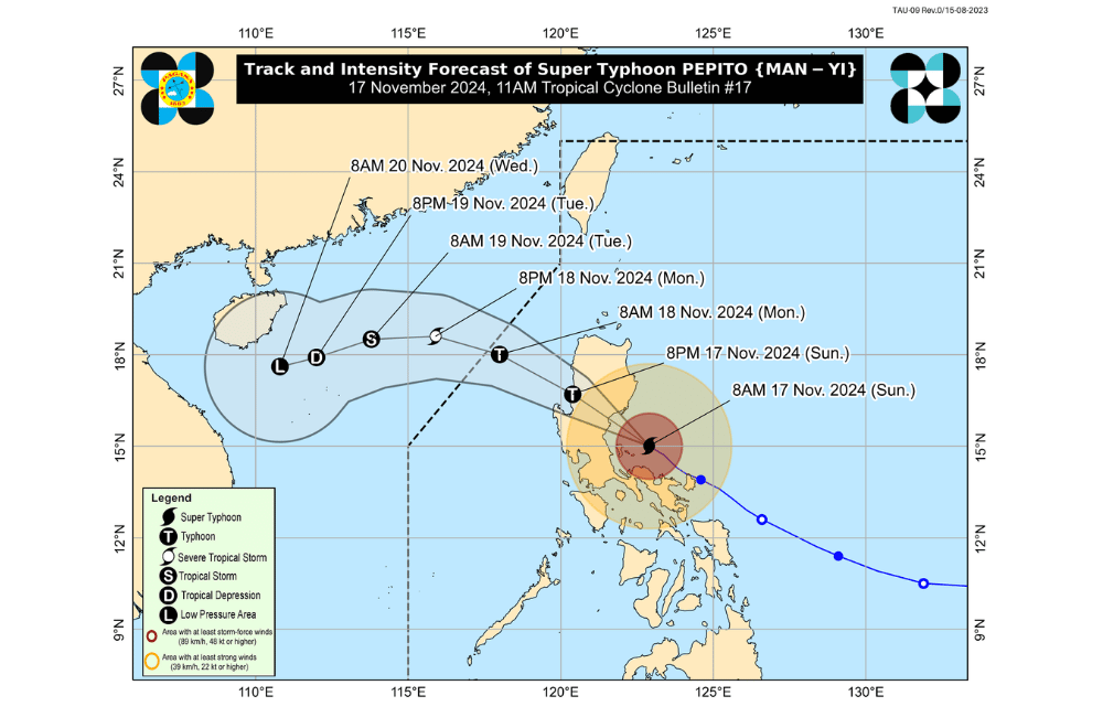
Super Typhoon #PepitoPH has maintained its strength and continues to pose a significant threat to Aurora and Northern Quezon, according to the Philippine Atmospheric, Geophysical and Astronomical Services Administration (PAGASA).
As of 11:00 a.m. on November 17, 2024, the eye of Super Typhoon "Pepito" was located approximately 120 km east-southeast of Baler, Aurora (15.2°N, 122.6°E).
The typhoon is moving northwestward at a speed of 20 km/h.
The storm currently has maximum sustained winds of 185 km/h near its center, with gustiness reaching up to 230 km/h.
Tropical Cyclone Wind Signal No. 5 has been raised over:
- The eastern portion of Polillo Islands (Burdeos, Patnanungan, Jomalig)
Tropical Cyclone Wind Signal No. 4 has been raised over:
- Aurora
- Quirino
- Nueva Vizcaya
- Southern portion of Ifugao (Kiangan, Lamut, Tinoc, Asipulo, Lagawe)
- Southern portion of Benguet (Bokod, Itogon, Tuba, Baguio City, Kabayan, La Trinidad, Sablan, Tublay, Kapangan, Atok)
- Southern portion of La Union (Burgos, Naguilian, Bauang, Caba, Tubao, Pugo, Aringay, Santo Tomas, Rosario, Agoo, Bagulin, City of San Fernando)
- Eastern portion of Pangasinan (Sison, Tayug, Binalonan, San Manuel, Umingan, Asingan, San Quintin, Santa Maria, Natividad, San Nicolas, Balungao, Pozorrubio, Laoac, San Jacinto, San Fabian, Manaoag, City of Urdaneta, Villasis, Rosales)
- Eastern portion of Nueva Ecija (General Tinio, Gabaldon, Laur, Bongabon, Palayan City, Pantabangan, Rizal, General Mamerto Natividad, Lupao, San Jose City, Llanera, Carranglan)
- Northern portion of Quezon (General Nakar, Infanta), including the rest of Polillo Islands and Calaguas Islands
Tropical Cyclone Wind Signal No. 3 has been raised over:
- Southern portion of Isabela (San Agustin, Jones, Echague, San Guillermo, Angadanan, Alicia, San Mateo, Ramon, San Isidro, City of Santiago, Cordon, Dinapigue, Roxas, San Manuel, Aurora, Cabatuan, City of Cauayan, Luna)
- Rest of Ifugao
- Mountain Province
- Southern portion of Abra (Tubo, Luba, Pilar, Villaviciosa, San Isidro, Pidigan, Langiden, San Quintin)
- Ilocos Sur
- Rest of Benguet
- Rest of La Union
- Rest of Pangasinan
- Northern portion of Zambales (Santa Cruz, Candelaria, Masinloc, Palauig)
- Tarlac
- Rest of Nueva Ecija
- Northern portion of Pampanga (Candaba, Arayat, Magalang, San Luis, San Simon, Mexico, Santa Ana, Apalit, Santo Tomas, City of San Fernando, Mabalacat City, Angeles City)
- Northern portion of Bulacan (Norzagaray, San Miguel, San Ildefonso, San Rafael, Doña Remedios Trinidad, Angat, City of San Jose del Monte, Santa Maria, Pandi, Baliuag, Bustos, Pulilan, Plaridel)
- Northern portion of Rizal (Pililla, Tanay, City of Antipolo, Rodriguez, Baras, San Mateo, Morong, Teresa)
- Eastern portion of Laguna (Santa Maria, Famy, Mabitac, Pakil, Pangil, Siniloan, Paete, Kalayaan, Lumban, Cavinti)
- Central and eastern portion of Quezon (Real, Perez, Calauag, Alabat, Quezon, Mauban, Sampaloc)
- Western portion of Camarines Norte (Santa Elena, Labo, Capalonga, Paracale, Vinzons, San Vicente, Talisay, Daet, Jose Panganiban)
Tropical Cyclone Wind Signal No. 2 has been raised over:
- Rest of Isabela
- Southwestern portion of mainland Cagayan (Enrile, Tuao, Solana, Tuguegarao City, Piat, Rizal)
- Kalinga
- Southern portion of Apayao (Conner, Kabugao)
- Rest of Abra
- Ilocos Norte
- Rest of Zambales
- Bataan
- Rest of Pampanga
- Rest of Bulacan
- Metro Manila
- Rest of Rizal
- Cavite
- Rest of Laguna
- Rest of Quezon
- Rest of Camarines Norte
- Camarines Sur
- Western portion of Catanduanes (Pandan, Caramoran, San Andres)
Tropical Cyclone Wind Signal No. 1 has been raised over:
- Rest of mainland Cagayan
- Rest of Apayao
- Batangas
- Northern portion of Occidental Mindoro (Abra de Ilog, Paluan), including Lubang Islands
- Northern portion of Oriental Mindoro (Puerto Galera, San Teodoro, Naujan, Baco, Victoria, Socorro, Pinamalayan, Gloria, Pola, City of Calapan)
- Northern portion of Romblon (Cajidiocan, San Fernando, Magdiwang, Romblon, Banton, Corcuera, Concepcion, San Andres, Calatrava, San Agustin)
- Marinduque
- Northern portion of Masbate (City of Masbate, Mobo, Aroroy, Baleno), including Burias and Ticao Islands
- Albay
- Sorsogon
- Rest of Catanduanes
Coastal Inundation Warning
- High Risk of Storm Surge: Peak surge heights exceeding 3.0 meters are expected over the next 48 hours in coastal areas of the following regions:
- Ilocos Region (western coast)
- Isabela
- Central Luzon
- Metro Manila
- CALABARZON
- Marinduque
- Bicol Region
- Northern Samar, Samar, and Eastern SamarResidents in these areas are advised to monitor Storm Surge Warning No. 10 issued at 8:00 AM today for further details.
Sea Conditions and Gale Warning
- Gale Warning in Effect: Rough to very rough seas are expected along the eastern, western, and southern seaboards of Luzon, and the eastern seaboard of Visayas.
- Sea Travel Advisory:
- Very Rough Seas (5.0–14.0 meters): Northern and eastern seaboards of Polillo Islands, Aurora, Camarines Norte, and Isabela, among others.
- Rough Seas (4.0–5.0 meters): Areas like Batanes, northern Cagayan, Zambales, and Oriental Mindoro.
- Moderate Seas (2.0–3.0 meters): Including Metro Manila, northern Cebu, Biliran, and parts of Dinagat Islands.
Sea travel is risky for all vessel types. Small craft operators should avoid venturing out to sea, especially under rough to very rough conditions.
Track and Intensity Outlook
Pepito is moving west-northwest over waters north of Camarines Provinces and east of Quezon.
It is forecasted to make landfall over northern Quezon or central/southern Aurora between noon and afternoon today.
After landfall, PEPITO will cross Central and Northern Luzon through the Sierra Madre, Caraballo, and Cordillera Central.
By tonight or early tomorrow morning (November 18), it is expected to emerge over coastal waters near Pangasinan or La Union.
Pepito is forecast to exit the Philippine Area of Responsibility (PAR) by tomorrow morning or afternoon.
The typhoon is expected to weaken upon crossing mainland Luzon due to interaction with the upland terrain and the northeasterly wind surge.
Further weakening over the West Philippine Sea is also likely.


