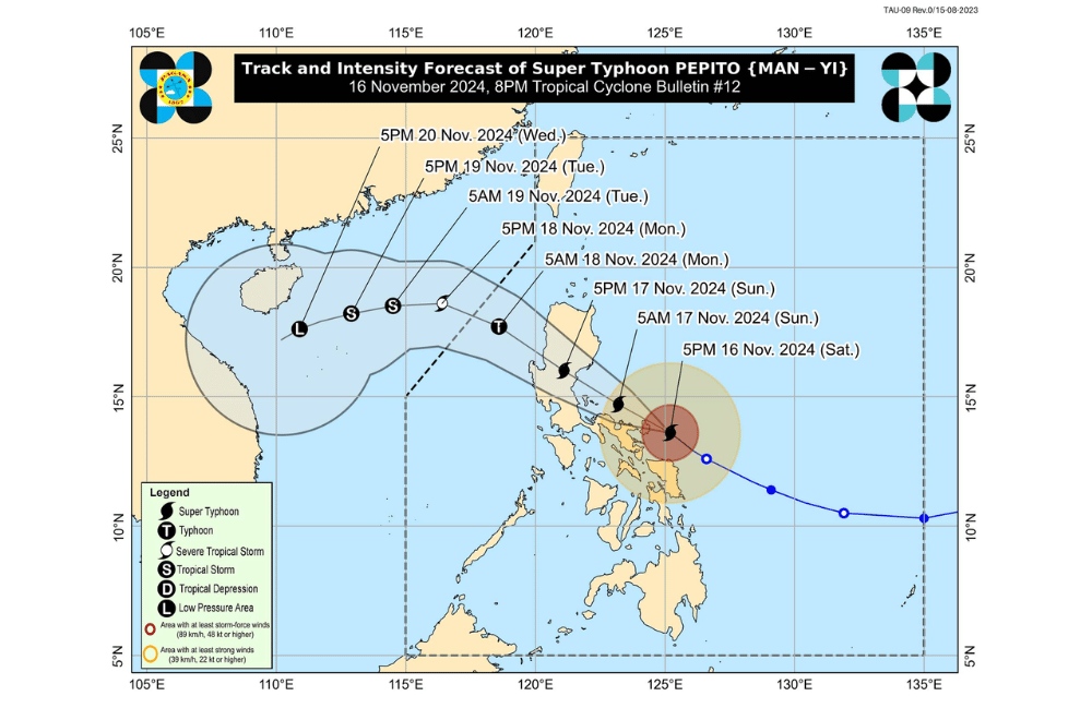
Super Typhoon #PepitoPH is about to make landfall along the eastern coast of Catanduanes, bringing devastating winds and heavy rains, according to the Philippine Atmospheric, Geophysical and Astronomical Services Administration (PAGASA).
As of 7:00 PM today, the center of #PepitoPH was located over the coastal waters of Gigmoto, Catanduanes (13.8°N, 124.8°E).
The typhoon is moving northwestward at a speed of 20 km/h.
It currently has maximum sustained winds of 195 km/h near its center, gustiness reaching up to 240 km/h, and a central pressure of 920 hPa. The extent of its strong to typhoon-force winds reaches up to 300 km from the center.
Tropical Cyclone Wind Signal No. 5 has been raised over:
- Luzon
- Catanduanes
- Northeastern portion of Camarines Sur (Caramoan, Garchitorena, Lagonoy, Presentacion)
Tropical Cyclone Wind Signal No. 4 has been raised over:
- Luzon
- Camarines Norte
- Northern and southeastern portions of Camarines Sur (Siruma, Tinambac, Goa, San Jose, Tigaon, Sagñay, Calabanga)
- Northeastern portion of Albay (Tabaco City, Tiwi, Malinao, Malilipot, Bacacay, Rapu-Rapu)
Tropical Cyclone Wind Signal No. 3 has been raised over:
- Luzon
- Aurora
- Polillo Islands
- Northern and eastern portions of mainland Quezon (Calauag, Guinayangan, Tagkawayan, Buenavista, Lopez, Quezon, Perez, Alabat, Gumaca, Plaridel, Atimonan, Real, General Nakar, Infanta, Mauban, Sampaloc)
- Eastern portion of Rizal (Tanay, Pililla)
- Northeastern portion of Laguna (Santa Maria, Famy, Mabitac, Pakil, Pangil, Siniloan, Paete, Kalayaan, Lumban, Cavinti)
- Rest of Camarines Sur
- Rest of Albay
- Northern portion of Sorsogon (Prieto Diaz, Sorsogon City, Gubat, Barcelona, Castilla, Casiguran, Pilar, Donsol)
Tropical Cyclone Wind Signal No. 2 has been raised over:
- Luzon
- Isabela
- Quirino
- Nueva Vizcaya
- Abra
- Kalinga
- Mountain Province
- Ifugao
- Benguet
- Ilocos Sur
- La Union
- Pangasinan
- Nueva Ecija
- Bulacan
- Tarlac
- Pampanga
- Zambales
- Bataan
- Metro Manila
- Rest of Rizal
- Rest of Laguna
- Cavite
- Rest of Quezon
- Marinduque
- Burias Island
- Ticao Island
- Rest of Sorsogon
- Visayas
- Northern Samar
- Northern portion of Samar (Matuguinao, Calbayog City, Santa Margarita, San Jorge, San Jose de Buan, Gandara)
- Northern portion of Eastern Samar (Dolores, Maslog, Jipapad, Arteche, Oras, San Policarpo)
Tropical Cyclone Wind Signal No. 1 has been raised over:
- Luzon
- Mainland Cagayan
- Apayao
- Ilocos Norte
- Batangas
- Northern portion of Occidental Mindoro (Sablayan, Santa Cruz, Mamburao, Abra de Ilog, Paluan) including Lubang Islands
- Northern portion of Oriental Mindoro (Puerto Galera, San Teodoro, Naujan, Baco, Victoria, Socorro, Pinamalayan, Bansud, Gloria, Pola, Calapan City, Bongabong, Roxas, Mansalay)
- Romblon
- Rest of Masbate
- Visayas
- Rest of Eastern Samar
- Rest of Samar
- Biliran
- Northern and central portions of Leyte (Tunga, Pastrana, San Miguel, Matag-Ob, Tolosa, Palo, Calubian, Leyte, Mayorga, Julita, Carigara, Babatngon, Dagami, Jaro, San Isidro, Santa Fe, Albuera, Villaba, La Paz, Palompon, Tabontabon, Tanauan, Merida, Ormoc City, Isabel, Dulag, Capoocan, Alangalang, Burauen, Tabango, Tacloban City, Kananga, Barugo)
- Northernmost portion of Cebu (Daanbantayan, Medellin) (including Bantayan Islands
- Northernmost portion of Iloilo (Carles)
Heavy Rainfall Forecast (November 16 to 17)
Intense to Torrential Rainfall (>200 mm):
- Catanduanes, Camarines Sur, Camarines Norte, Quezon, Aurora, Benguet, Nueva Vizcaya, Quirino, Nueva Ecija, Pangasinan
Heavy to Intense Rainfall (100–200 mm):
- La Union, Tarlac, Bulacan, Pampanga, Zambales, Rizal, Albay, Sorsogon, Bataan
Moderate to Heavy Rainfall (50–100 mm):
- Northern Samar, Masbate, Metro Manila, Cavite, Laguna, Marinduque, Batangas, Cagayan, Isabela, Ifugao, Mountain Province, Kalinga, Abra, Ilocos Sur
Coastal Hazards
Storm Surge:
- High risk of life-threatening storm surge exceeding 3 meters in:
- Ilocos Region (western coast), Isabela, Central Luzon, Metro Manila, CALABARZON, Marinduque, Bicol Region, Northern Samar, Samar, and Eastern Samar
Sea Conditions (24-Hour Outlook):
- Very rough to high seas (5.0–14.0 m):
- Catanduanes, Camarines Norte, Aurora, Polillo Islands, Quezon, Northern Samar, Albay, Sorsogon, Eastern Samar
- Sea travel is highly dangerous. Mariners should remain in port or seek shelter.
- Rough seas (3.0–4.0 m):
- Batanes, Babuyan Islands, Pangasinan, La Union, Marinduque, Romblon, Quezon
- Moderate seas (2.0–2.5 m):
- Zambales, Metro Manila, Dinagat Islands, Samar, Leyte, Surigao del Sur
Track and Landfall
- Super Typhoon Pepito is forecast to make landfall over northern Catanduanes between 8:00 PM to 10:00 PM tonight.
- The storm will continue its west-northwest path, potentially crossing:
- Polillo Islands (morning of November 17)
- Aurora or northern Quezon (noon to afternoon, November 17)
- It will pass over Central Luzon and exit into the West Philippine Sea by late evening on November 17 or early November 18.
Intensity:
- Expected to make landfall as a super typhoon over Catanduanes and Aurora.
- Weakening is anticipated as the storm traverses Luzon, but it is likely to retain typhoon strength until it reemerges over water.


