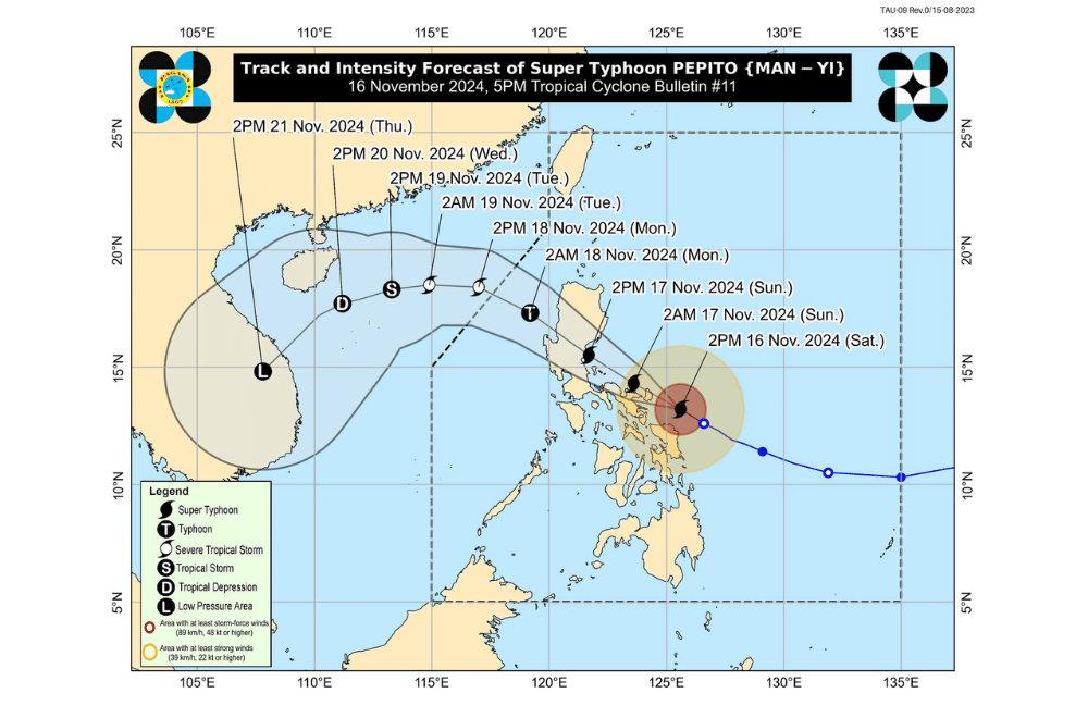
Super Typhoon #PepitoPH continues to move west-northwestward, threatening the northeastern Bicol region with potentially catastrophic and life-threatening conditions, according to the Philippine Atmospheric, Geophysical and Astronomical Services Administration (PAGASA).
As of 4:00 p.m. on November 16, 2024, the center of #PepitoPH was located 120 km east of Virac, Catanduanes (13.4°N, 125.3°E).
The super typhoon is moving at a speed of 20 km/h in a west-northwestward direction.
It currently has maximum sustained winds of 195 km/h near its center, with gustiness reaching up to 240 km/h. Strong to typhoon-force winds extend outward up to 300 km from the center.
Tropical Cyclone Wind Signal No. 5 has been raised over:
- Luzon
- Catanduanes
- Northeastern portion of Camarines Sur (Caramoan, Garchitorena, Lagonoy, Presentacion)
Tropical Cyclone Wind Signal No. 4 has been raised over:
- Luzon
- Camarines Norte
- Northern and southeastern portions of Camarines Sur (Siruma, Tinambac, Goa, San Jose, Tigaon, Sagñay, Calabanga)
- Northeastern portion of Albay (Tabaco City, Tiwi, Malinao, Malilipot, Bacacay, Rapu-Rapu)
Tropical Cyclone Wind Signal No. 3 has been raised over:
- Luzon
- Polillo Islands
- Northern and eastern portions of mainland Quezon (Calauag, Guinayangan, Tagkawayan, Buenavista, Lopez, Quezon, Perez, Alabat, Gumaca, Plaridel, Atimonan, Mauban, Real, General Nakar, Infanta)
- Rest of Camarines Sur
- Rest of Albay
- Northern portion of Sorsogon (Prieto Diaz, Sorsogon City, Gubat, Barcelona, Castilla, Casiguran, Pilar, Donsol)
- Visayas
- Eastern and central portions of Northern Samar (Palapag, Laoang, Mapanas, Gamay, Lapinig, Catubig, Pambujan, Las Navas, Biri, Bobon, Catarman, Mondragon, San Roque, Silvino Lobos, Lope de Vega, San Jose)
- Northern portion of Eastern Samar (San Policarpo, Arteche, Oras, Jipapad)
Tropical Cyclone Wind Signal No. 2 has been raised over:
- Luzon
- Southern portion of Isabela
- Quirino
- Nueva Vizcaya
- Ifugao
- Benguet
- La Union
- Pangasinan
- Aurora
- Nueva Ecija
- Bulacan
- Tarlac
- Pampanga
- Zambales
- Bataan
- Metro Manila
- Cavite
- Rizal
- Laguna
- Marinduque
- Rest of Quezon
- Sorsogon
- Burias Island
- Ticao Island
- Visayas
- Central portion of Eastern Samar (Dolores, Maslog, Can-Avid, Taft, Sulat, San Julian, Borongan City)
- Northern portion of Samar (Matuguinao, Calbayog City, Santa Margarita, San Jorge, San Jose de Buan, Tarangnan, Motiong, Gandara, Jiabong, Catbalogan City, Paranas, Hinabangan, San Sebastian, Pagsanghan)
- Rest of Northern Samar
Tropical Cyclone Wind Signal No. 1 has been raised over:
- Luzon
- Mainland Cagayan
- Rest of Isabela
- Apayao
- Kalinga
- Abra
- Mountain Province
- Ilocos Norte
- Ilocos Sur
- La Union
- Rest of Pangasinan
- Zambales
- Batangas
- Northern portion of Occidental Mindoro (Sablayan, Santa Cruz, Mamburao, Abra de Ilog, Paluan) including Lubang Islands
- Northern portion of Oriental Mindoro (Puerto Galera, San Teodoro, Naujan, Baco, Victoria, Socorro, Pinamalayan, Bansud, Gloria, Pola, Calapan City, Bongabong, Roxas, Mansalay)
- Romblon
- Rest of Masbate
- Visayas
- Rest of Eastern Samar
- Rest of Samar
- Biliran
- Northern and central portions of Leyte (Tunga, Pastrana, San Miguel, Matag-Ob, Tolosa, Palo, Calubian, Leyte, Mayorga, Julita, Carigara, Babatngon, Dagami, Jaro, San Isidro, Santa Fe, Albuera, Villaba, La Paz, Palompon, MacArthur, Tabontabon, Tanauan, Merida, Ormoc City, Isabel, Dulag, Capoocan, Alangalang, Burauen, Tabango, Tacloban City, Kananga, Barugo, Abuyog, Javier, Baybay City, Mahaplag)
- Northeastern portion of Southern Leyte (Silago)
- Northernmost portion of Cebu (Daanbantayan, Medellin, Bantayan Islands)
- Northernmost portion of Iloilo (Carles)
- Mindanao
- Northern portion of Dinagat Islands (Loreto, Tubajon)
Heavy Rainfall Outlook
- Intense to Torrential (Over 200 mm): Catanduanes, Camarines Sur, Camarines Norte
- Heavy to Intense (100–200 mm): Albay, Quezon, Northern Samar, Eastern Samar
- Moderate to Heavy (50–100 mm): Sorsogon, Samar, Leyte, Biliran, Masbate
Residents in these areas are advised to prepare for potential flooding and landslides.
Coastal Inundation and Sea Conditions
PAGASA warns of life-threatening storm surges exceeding 3.0 meters along exposed and low-lying coasts in the following regions:
- Ilocos Region (western coast)
- Isabela, Central Luzon, Metro Manila, CALABARZON
- Marinduque, Bicol Region, Northern Samar, Samar, Eastern Samar, Biliran
Additionally, gale warnings remain in effect for the eastern and southern seaboards of Southern Luzon and Visayas, with waves potentially reaching:
- Up to 14 meters: Catanduanes
- Up to 12 meters: Northern Camarines Sur
- Up to 9 meters: Northern Samar, Camarines Norte
- Up to 7 meters: Eastern Albay, Sorsogon, Eastern Samar
Sea travel is highly risky for all types of vessels, and mariners are urged to stay in port or seek shelter until conditions improve.
Track and Intensity Outlook
#PepitoPH is expected to make landfall in Catanduanes and traverse parts of Bicol Region, Central Luzon, Quezon, and southern Ilocos and Cordillera regions before exiting the Philippine Area of Responsibility (PAR) by Monday, November 18.
- Likely landfall as a super typhoon in Catanduanes, possibly intensifying further if eyewall replacement occurs before landfall.
- Heavy rainfall, strong winds, and storm surges are expected across affected regions, regardless of the exact landfall point.


