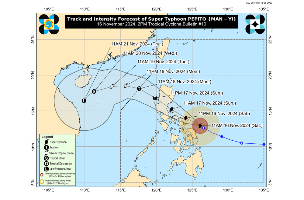
Super Typhoon #PepitoPH continues to intensify as it moves west-northwestward, threatening the Northeastern Bicol Region with potentially catastrophic and life-threatening conditions, according to the Philippine Atmospheric, Geophysical and Astronomical Services Administration (PAGASA).
As of 2:00 p.m. on November 16, 2024, the eye of "Pepito" was located approximately 145 km east-northeast of Catarman, Northern Samar (13.1°N, 125.8°E).
The super typhoon is moving west-northwestward at a speed of 20 km/h, with maximum sustained winds of 195 km/h near its center and gustiness reaching up to 240 km/h.
Tropical Cyclone Wind Signals (TCWS) Raised:
Tropical Cyclone Wind Signal No. 5
- Catanduanes
Tropical Cyclone Wind Signal No. 4
- Northeastern Camarines Sur (Garchitorena, Caramoan, Presentacion, Siruma, Tinambac, Goa, Lagonoy, San Jose, Tigaon, Sagñay)
- Northeastern Albay (Tabaco City, Tiwi, Malinao, Malilipot, Bacacay, Rapu-Rapu)
Tropical Cyclone Wind Signal No. 3
Luzon:
- Polillo Islands
- Southeastern mainland Quezon (Calauag, Guinayangan, Tagkawayan, Buenavista)
- Camarines Norte
- The rest of Camarines Sur
- The rest of Albay
- Northern Sorsogon (Prieto Diaz, Sorsogon City, Gubat, Barcelona, Castilla, Casiguran, Pilar, Donsol)
Visayas:
- Eastern and central Northern Samar (Palapag, Laoang, Mapanas, Gamay, Lapinig, Catubig, Pambujan, Las Navas, Biri, Bobon, Catarman, Mondragon, San Roque, Silvino Lobos, Lope de Vega, San Jose)
- Northern Eastern Samar (San Policarpo, Arteche, Oras, Jipapad)
Tropical Cyclone Wind Signal No. 2
Luzon:
- Southern Isabela (Dinapigue, Cordon, Ramon, Alicia, Cauayan City, Angadanan, Santiago City, San Isidro, Echague, Jones, San Agustin, San Guillermo, San Mariano, Benito Soliven, Naguilian, Palanan)
- Quirino
- Nueva Vizcaya
- Eastern Pangasinan (San Nicolas, Umingan, Natividad, San Quintin, Tayug, Santa Maria, Rosales, Balungao, San Manuel, Villasis, Malasiqui, Bautista, Mapandan, Binalonan, Alcala, Asingan, Santo Tomas, Urdaneta City, Laoac, Manaoag, Bayambang, Santa Barbara)
- Aurora
- Nueva Ecija
- Bulacan
- Tarlac
- Pampanga
- Southern Zambales (Botolan, Cabangan, San Marcelino, San Felipe, San Narciso, San Antonio, Castillejos, Subic, Olongapo City)
- Bataan
- Metro Manila
- Rizal,
- The rest of Quezon
- Laguna
- Cavite
- Marinduque
- Burias Island
- Ticao Island
Visayas:
- Central Eastern Samar (Dolores, Maslog, Can-Avid, Taft, Sulat, San Julian, Borongan City)
- The rest of Northern Samar
- Central Samar
Tropical Cyclone Wind Signal No. 1
Luzon:
- Mainland Cagayan
- The rest of Isabela
- Apayao
- Kalinga
- Abra
- Mountain Province Ifugao
- Benguet
- Ilocos Norte
- Ilocos Sur
- La Union
- The rest of Pangasinan
- The rest of Zambales
- Batangas
- Northern Occidental Mindoro (Sablayan, Santa Cruz, Mamburao, Abra de Ilog, Paluan, Lubang Islands)
- Northern Oriental Mindoro (Puerto Galera, San Teodoro, Naujan, Baco, Victoria, Socorro, Pinamalayan, Bansud, Gloria, Pola, Calapan City, Bongabong, Roxas, Mansalay)
- Romblon
- The rest of Masbate
Visayas:
- Rest of Eastern Samar
- Rest of Samar
- Biliran
- Central Leyte (Tunga, Pastrana, San Miguel, Matag-Ob, Tolosa, Palo, Calubian, Leyte, Mayorga, Julita, Carigara, Babatngon, Dagami, Jaro, San Isidro, Santa Fe, Albuera, Villaba, La Paz, Palompon, Macarthur, Tabontabon, Tanauan, Merida, Ormoc City, Isabel, Dulag, Capoocan, Alangalang, Burauen, Tabango, Tacloban City, Kananga, Barugo, Abuyog, Javier, Baybay City, Mahaplag)
- Northeastern Southern Leyte (Silago)
- Northernmost Cebu (Daanbantayan, Medellin, Bantayan Islands)
- Northernmost Iloilo (Carles)
Mindanao:
- Northern Dinagat Islands (Loreto, Tubajon)
Heavy Rainfall Outlook
- Intense to Torrential (Over 200 mm): Catanduanes, Camarines Sur, Camarines Norte
- Heavy to Intense (100–200 mm): Albay, Quezon, Northern Samar, Eastern Samar
- Moderate to Heavy (50–100 mm): Sorsogon, Samar, Leyte, Biliran, Masbate
Residents in these areas are advised to prepare for potential flooding and landslides.
Coastal Inundation and Sea Conditions
PAGASA warns of life-threatening storm surges exceeding 3.0 meters along exposed and low-lying coasts in the following regions:
- Ilocos Region (western coast)
- Isabela, Central Luzon, Metro Manila, CALABARZON
- Marinduque, Bicol Region, Northern Samar, Samar, Eastern Samar, Biliran
Additionally, gale warnings remain in effect for the eastern and southern seaboards of Southern Luzon and Visayas, with waves potentially reaching:
- Up to 14 meters: Catanduanes
- Up to 12 meters: Northern Camarines Sur
- Up to 9 meters: Northern Samar, Camarines Norte
- Up to 7 meters: Eastern Albay, Sorsogon, Eastern Samar
Sea travel is highly risky for all types of vessels, and mariners are urged to stay in port or seek shelter until conditions improve.
Track and Intensity Outlook
Typhoon Pepito is projected to move west-northwest, making landfall over Catanduanes, with possible scenarios including landfall in Camarines Sur or Albay if it shifts slightly south, or Quezon and Aurora if it shifts north.
- After crossing Luzon, Pepito is expected to exit the Philippine Area of Responsibility (PAR) by Monday.
- Pepito may reach super typhoon intensity as it approaches Catanduanes, although some weakening is expected over Luzon.
PAGASA said even areas outside Pepito’s direct path may experience heavy rains, strong winds, and storm surges.


