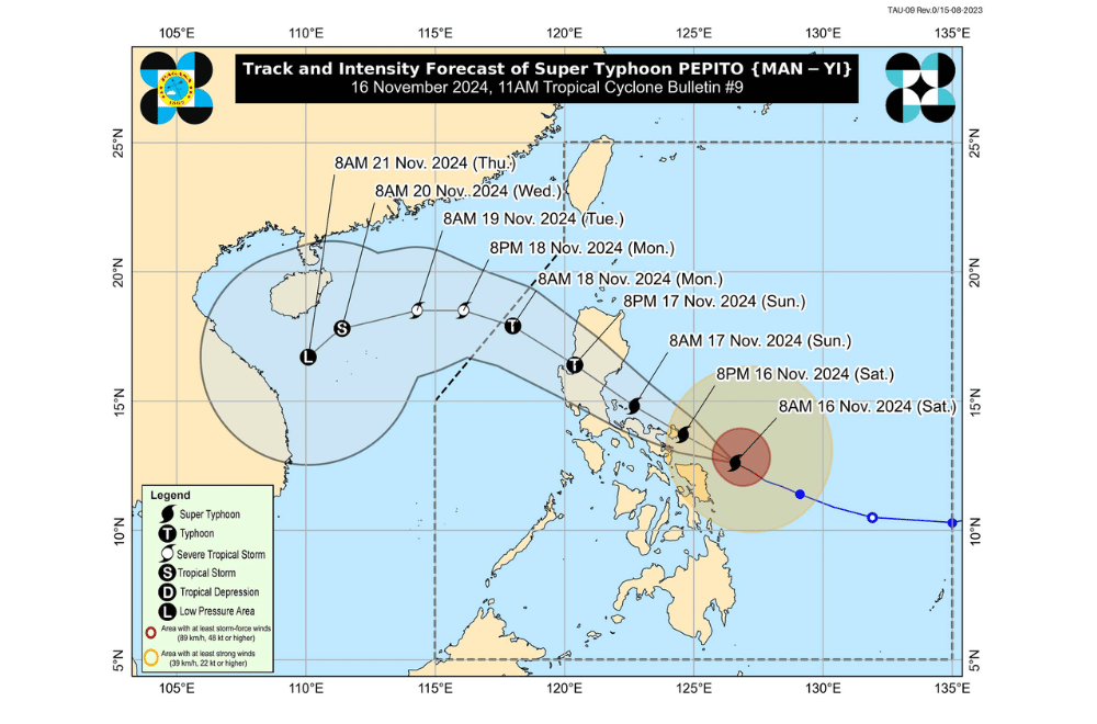
Super Typhoon #PepitoPH continues to intensify as it moves west-northwestward, posing a significant threat to the Bicol Region, according to the Philippine Atmospheric, Geophysical and Astronomical Services Administration (PAGASA).
As of 10:00 a.m. on November 16, 2024, the center of Super Typhoon #PepitoPH was located 185 km east of Catarman, Northern Samar, or 250 km east of Juban, Sorsogon (12.8°N, 126.3°E).
The super typhoon is moving west-northwestward at a speed of 25 km/h.
It currently has maximum sustained winds of 185 km/h near its center, with gusts reaching up to 230 km/h and a central pressure of 925 hPa. Strong to typhoon-force winds extend outward up to 440 km from its center.
Tropical Cyclone Wind Signal No. 4 has been raised over:
- Luzon:
- Catanduanes
- Northeastern portion of Camarines Sur (Garchitorena, Presentacion, Caramoan, Lagonoy, San Jose)
Tropical Cyclone Wind Signal No. 3 has been raised over:
- Luzon:
- Eastern portion of Camarines Norte (Vinzons, Talisay, Mercedes, Daet, Basud, San Vicente, San Lorenzo Ruiz)
- Northern and southeastern portions of Camarines Sur (Sagñay, Tigaon, Goa, Tinambac, Siruma, Buhi, Ocampo, Iriga City, Sipocot, Pili, Cabusao, Calabanga, Bombon, Magarao, Canaman, Naga City, Camaligan)
- Eastern portion of Albay (City of Tabaco, Malilipot, Tiwi, Malinao, Santo Domingo, Manito, Legazpi City, Bacacay, Rapu-Rapu)
- Northeastern portion of Sorsogon (Prieto Diaz, City of Sorsogon, Gubat)
- Visayas:
- Eastern portion of Northern Samar (Palapag, Laoang, Mapanas, Gamay, Lapinig, Catubig, Pambujan)
- Northern portion of Eastern Samar (San Policarpo, Arteche, Oras, Jipapad)
Tropical Cyclone Wind Signal No. 2 has been raised over:
- Luzon:
- Southeastern portion of Isabela (Dinapigue)
- Aurora
- Quezon
- Eastern portion of Rizal (Tanay, Pililla, Jala-Jala)
- Laguna
- Rest of Camarines Norte
- Rest of Camarines Sur
- Rest of Albay
- Rest of Sorsogon
- Burias Island and Ticao Island
- Visayas:
- Central portion of Eastern Samar (Dolores, Maslog, Can-Avid, Taft, Sulat, San Julian, City of Borongan)
- Northern portion of Samar (Matuguinao, Calbayog City, Santa Margarita, San Jorge, San Jose de Buan, Tarangnan, Motiong, Gandara, Jiabong, City of Catbalogan, Paranas, Hinabangan, San Sebastian, Pagsanghan)
- Rest of Northern Samar
Tropical Cyclone Wind Signal No. 1 has been raised over:
- Luzon:
- Mainland Cagayan
- Rest of Isabela
- Quirino
- Nueva Vizcaya
- Apayao
- Kalinga
- Abra
- Mountain Province
- Ifugao
- Benguet
- Ilocos Norte
- Ilocos Sur
- La Union
- Pangasinan
- Nueva Ecija
- Bulacan
- Tarlac
- Pampanga
- Zambales
- Bataan
- Metro Manila
- Rest of Rizal
- Cavite
- Batangas
- Marinduque
- Northern portion of Oriental Mindoro (Puerto Galera, San Teodoro, Naujan, Baco, Victoria, Socorro, Pinamalayan, Bansud, Gloria, Pola, City of Calapan)
- Romblon
- Rest of Masbate
- Visayas:
- Rest of Eastern Samar
- Rest of Samar
- Biliran
- Northern and central portions of Leyte (Tunga, Pastrana, San Miguel, Matag-Ob, Tolosa, Palo, Calubian, Leyte, Mayorga, Julita, Carigara, Babatngon, Dagami, Jaro, San Isidro, Santa Fe, Albuera, Villaba, La Paz, Palompon, Macarthur, Tabontabon, Tanauan, Merida, Ormoc City, Isabel, Dulag, Capoocan, Alangalang, Burauen, Tabango, Tacloban City, Kananga, Barugo, Abuyog, Javier, City of Baybay, Mahaplag)
- Northeastern portion of Southern Leyte (Silago)
- Northernmost portion of Cebu (Daanbantayan, Medellin) including Bantayan Islands
- Northernmost portion of Iloilo (Carles)
- Mindanao:
- Northern portion of Dinagat Islands (Loreto, Tubajon)
Heavy Rainfall Warnings
Pepito will bring significant rainfall, prompting the following advisories:
- Intense to Torrential Rainfall (>200mm)
- Catanduanes, Camarines Sur, Camarines Norte
- Heavy to Intense Rainfall (100–200mm)
- Albay, Quezon, Northern Samar, Eastern Samar
- Moderate to Heavy Rainfall (50–100mm)
- Sorsogon, Samar, Leyte, Biliran, Masbate
Residents in these areas are advised to prepare for possible flooding and landslides.
Storm Surge Advisory
A life-threatening storm surge with heights exceeding 3 meters is forecast in the next 48 hours along the coasts of:
- Ilocos Region (western coast)
- Isabela
- Central Luzon
- Metro Manila
- CALABARZON
- Marinduque
- Bicol Region
- Northern Samar, Samar, Eastern Samar, Biliran, Leyte (northeastern coasts)
Residents in low-lying areas should heed evacuation orders from local officials.
Coastal Waters Warning
Very rough to extremely rough seas are expected, making sea travel dangerous for all types of vessels. Wave heights include:
- Up to 14.0 meters: Catanduanes
- Up to 12.0 meters: Northern Camarines Sur
- Up to 9.0 meters: Northern Samar, Camarines Norte
- Up to 7.0 meters: Albay, Sorsogon, Eastern Samar
Small seacraft operators are advised to remain in port and avoid navigation until conditions improve.
Typhoon Path and Intensity
Pepito is currently approaching its peak intensity, with radar data showing signs of potential eyewall replacement. Key details include:
- Landfall areas: Catanduanes, or possibly Camarines Sur, Albay, Quezon, or Aurora (depending on its path).
- Intensity: Expected to make landfall as a super typhoon or typhoon, with significant weakening once over Luzon.
- Path: The typhoon will cross the Bicol Region, Central Luzon, and Northern Luzon provinces (Benguet, La Union, Pangasinan) before moving over the West Philippine Sea.


