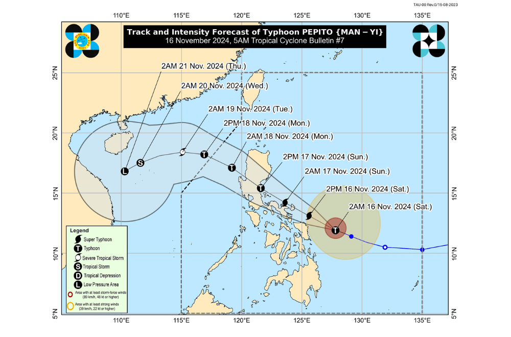
Typhoon #PepitoPH continues to intensify as it threatens parts of Southern Luzon and Eastern Visayas, nearing super typhoon status, according to the Philippine Atmospheric, Geophysical and Astronomical Services Administration (PAGASA).
As of 8:00 a.m. on November 16, 2024, the center of "Pepito" was located 235 km east of Catarman, Northern Samar, based on all available data, including Guiuan Weather Surveillance Radar.
The typhoon is moving northwestward at a speed of 25 km/h.
"Pepito" has maximum sustained winds of 175 km/h near its center, with gustiness reaching up to 215 km/h.
Tropical Cyclone Wind Signal No. 3 has been raised over:
- Luzon:
- Catanduanes
- Eastern portion of Albay (Rapu-Rapu, Bacacay, Santo Domingo, City of Tabaco, Malilipot, Tiwi, Malinao)
- Eastern portion of Camarines Sur (Caramoan, Presentacion, San Jose, Garchitorena, Lagonoy, Sagñay, Tigaon, Goa, Tinambac, Siruma)
- Easternmost portion of Sorsogon (Prieto Diaz)
- Visayas:
- Eastern portion of Northern Samar (Palapag, Laoang, Mapanas, Gamay, Lapinig, Catubig, Pambujan)
- Northernmost portion of Eastern Samar (San Policarpo, Arteche, Oras, Jipapad)
Tropical Cyclone Wind Signal No. 2 has been raised over:
- Luzon:
- Rest of Camarines Sur
- Rest of Albay
- Rest of Sorsogon
- Ticao Island
- Camarines Norte
- Northeastern portion of Quezon (Perez, Alabat, Quezon, Calauag, Guinayangan, Tagkawayan) including Polillo Islands
- Visayas:
- Northern portion of Eastern Samar (Dolores, Maslog, Can-Avid, Taft, Sulat, San Julian, City of Borongan)
- Northern portion of Samar (Matuguinao, Calbayog City, Santa Margarita, San Jorge, San Jose de Buan, Tarangnan, Motiong, Gandara, Jiabong, City of Catbalogan, Paranas, Hinabangan, San Sebastian, Pagsanghan)
- Rest of Northern Samar
Tropical Cyclone Wind Signal No. 1 has been raised over:
- Luzon:
- Rest of Masbate, including Burias Island
- Marinduque
- Romblon
- Rest of Quezon
- Laguna
- Rizal
- Cavite
- Batangas
- Metro Manila
- Zambales
- Bataan
- Bulacan
- Pampanga
- Tarlac
- Nueva Ecija
- Aurora
- Quirino
- Nueva Vizcaya
- Isabela
- Mainland Cagayan
- Pangasinan
- La Union
- Ilocos Sur
- Ilocos Norte
- Abra
- Apayao
- Kalinga
- Mountain Province
- Ifugao
- Benguet
- Visayas:
- Rest of Eastern Samar
- Rest of Samar
- Biliran
- Northern and central portions of Leyte (Tunga, Pastrana, San Miguel, Matag-Ob, Tolosa, Palo, Calubian, Leyte, Mayorga, Julita, Carigara, Babatngon, Dagami, Jaro, San Isidro, Santa Fe, Albuera, Villaba, La Paz, Palompon, Macarthur, Tabontabon, Tanauan, Merida, Ormoc City, Isabel, Dulag, Capoocan, Alangalang, Burauen, Tabango, Tacloban City, Kananga, Barugo, Abuyog, Javier, City of Baybay, Mahaplag)
- Northeastern portion of Southern Leyte (Silago)
- Northernmost portion of Cebu (Daanbantayan, Medellin) including Bantayan Islands
- Northernmost portion of Iloilo (Carles)
- Mindanao:
- Northern portion of Dinagat Islands (Loreto, Tubajon)
Sea Condition Outlook (Next 24 Hours)
A Gale Warning is in effect for the eastern and southern seaboards of Southern Luzon and the eastern seaboard of Visayas. Sea travel is highly risky across affected areas, with conditions detailed as follows:
Very Rough to Extremely High Seas
- Up to 14.0 m: Seaboard of Catanduanes
- Up to 12.0 m: Northern seaboard of Camarines Sur
- Up to 9.0 m: Northern and eastern seaboards of Northern Samar, seaboard of Camarines Norte
- Up to 7.0 m: Eastern seaboards of Albay, Sorsogon, and Eastern Samar
- Up to 5.5 m: Remaining seaboards of Camarines Sur
- Up to 4.5 m: Northern and eastern seaboards of Polillo Islands, Aurora, Burias and Ticao Islands
Mariners of all vessels are advised to remain in port and seek safe harbor until conditions improve.
Rough Seas
- Up to 4.0 m: Dinagat Islands, northern Quezon
- Up to 3.5 m: Isabela, Surigao del Norte, including Siargao and Bucas Grande Islands
- Up to 3.0 m: Eastern seaboards of Cagayan, Babuyan Islands, Surigao del Sur, Marinduque, Romblon, northern Cebu
Small watercraft and motorbancas should avoid sea travel under these conditions.
Moderate Seas
- Up to 2.5 m: Batanes, Davao Oriental
- Up to 2.0 m: Oriental Mindoro, Aklan, Capiz, Davao del Sur, Ilocos Region
Mariners of small vessels should take precautionary measures and avoid unnecessary sea travel.
Track and Intensity Outlook
Tropical Cyclone Pepito is moving west-northwest and is expected to make landfall in Catanduanes tonight or early tomorrow morning (November 17). Alternate landfall scenarios include:
- Eastern Camarines Sur, Albay, or Sorsogon (same timeframe)
- Eastern Quezon or Aurora (November 17 afternoon or evening)
Pepito is forecast to traverse the Bicol Region, Quezon, Central Luzon provinces, Benguet, La Union, and Pangasinan before emerging over the West Philippine Sea by Monday morning.


