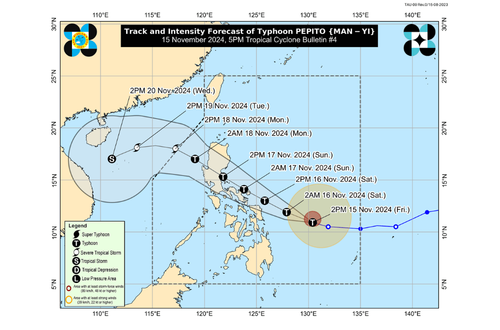
Typhoon #Pepito continues to intensify rapidly as it moves west-northwestward, now affecting more areas in the Visayas and Luzon, according to the Philippine Atmospheric, Geophysical and Astronomical Services Administration (PAGASA).
As of 5:00 p.m. of November 15, 2024, the center of Typhoon #Pepito was located 465 km east of Guiuan, Eastern Samar.
The storm is moving at a speed of 30 km/h in a west-northwestward direction.
Typhoon #Pepito currently has maximum sustained winds of 150 km/h near its center, with gustiness reaching up to 185 km/h.
Tropical Cyclone Wind Signal No. 2 has been raised over:
- The eastern portion of Northern Samar (Mapanas, Gamay, Palapag, Lapinig, Silvino Lobos, Laoang, Catubig, Las Navas, Pambujan, Mondragon, San Roque, Catarman, Lope de Vega)
- The northern portion of Eastern Samar (Arteche, Oras, San Policarpo, Dolores, Jipapad, Maslog, Can-Avid)
- The northeastern portion of Samar (San Jose de Buan, Matuguinao)
Tropical Cyclone Wind Signal No. 1 has been raised over:
Luzon:
- Aurora
- Quezon
- The eastern portion of Laguna (Santa Maria, Famy, Siniloan, Pangil, Mabitac, Pakil, Paete, Kalayaan, Lumban, Cavinti, Luisiana, Pagsanjan, Santa Cruz, Magdalena, Majayjay, Liliw, Nagcarlan, San Pablo City, Rizal)
- Marinduque
- Camarines Norte
- Camarines Sur
- Catanduanes
- Albay
- Sorsogon
- Masbate
Visayas:
- The rest of Northern Samar
- The rest of Eastern Samar
- The rest of Samar
- Biliran
Gale Warnings
A Gale Warning has been issued over the eastern seaboard of Visayas. Mariners are advised to take extreme caution as the sea conditions are very rough to high, with waves reaching up to 8 meters in some areas.
Sea Conditions in the Next 24 Hours
- Very Rough to High Seas (up to 8.0m): Eastern seaboards of Catanduanes, Albay, Sorsogon, and Eastern Samar, as well as the northern and eastern seaboards of Northern Samar.
- Rough Seas (up to 4.0m): Eastern seaboard of Dinagat Islands, Surigao del Sur, and Siargao Islands.
- Moderate to Rough Seas: Several other coastal areas including Batanes, Isabela, Aurora, and parts of Quezon and Leyte.
Sea Travel Advisory
- All mariners, including those with small seacrafts like motorbancas, should avoid venturing out to sea.
- Sea travel is risky for all types of vessels, and those already at sea should seek shelter or return to port.
Typhoon Track and Intensity Outlook
- Typhoon Pepito is forecast to move west-northwestward and could make landfall near Catanduanes on November 16 or early November 17.
- Other possible landfall areas include the eastern coasts of Camarines Sur, Albay, Sorsogon, and Northern Samar.
- After landfall, Pepito will continue its west-northwestward movement, likely affecting Bicol Region, Quezon, Central Luzon, and Pangasinan before exiting the Philippines on November 18.
Intensity
- Pepito is expected to intensify and may reach super typhoon strength before landfall.
- It will likely weaken as it passes over the landmass of Central Luzon but will remain a typhoon until it reaches the West Philippine Sea on November 18, where it is expected to downgrade to a severe tropical storm.
Other Hazards
- The public is urged to stay alert as heavy rainfall, strong winds, and storm surge are expected, especially in areas near the typhoon's path.


