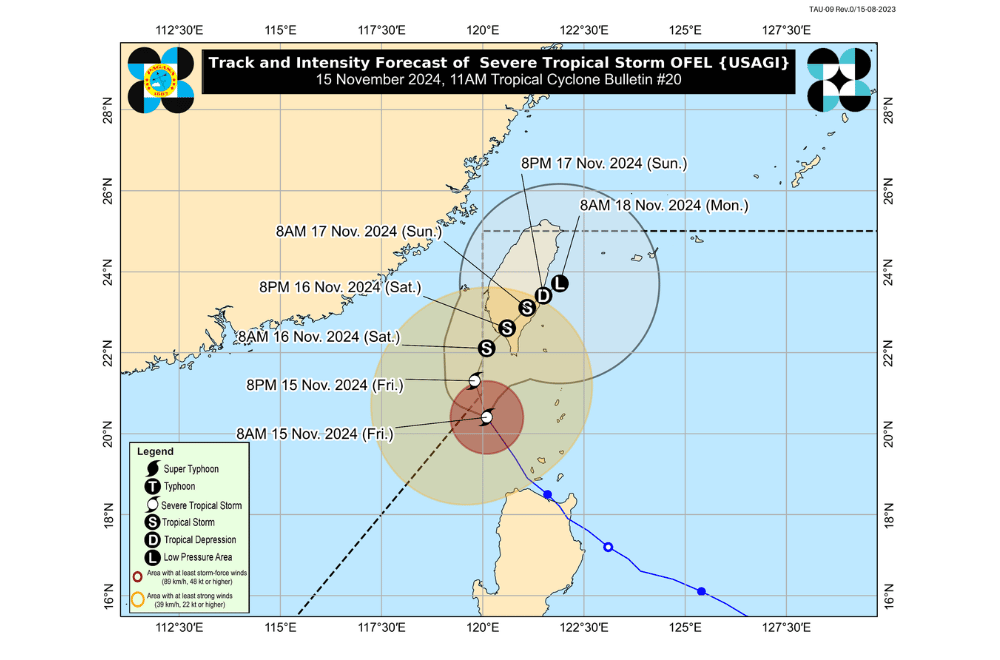
Severe Tropical Storm #OfelPH has weakened slightly while moving north-northwestward over the Luzon Strait, according to the Philippine Atmospheric, Geophysical and Astronomical Services Administration (PAGASA).
As of 11:00 a.m. on November 15, 2024, the center of "Ofel" was located approximately 215 km northwest of Calayan, Cagayan.
The storm is moving at a speed of 20 km/h in a north-northwestward direction.
The storm currently has maximum sustained winds of 110 km/h near its center, with gustiness reaching up to 135 km/h.
Tropical Cyclone Wind Signal No. 2 has been raised over:
- Batanes
Tropical Cyclone Wind Signal No. 1 has been raised over:
- The northern portion of Cagayan (Pamplona, Claveria, Abulug, Sanchez-Mira, Santa Praxedes, Ballesteros)
- Babuyan Islands
- The northern portion of Apayao (Luna, Santa Marcela, Calanasan)
- The northern portion of Ilocos Norte (Pagudpud, Adams, Bangui, Dumalneg, Burgos, Pasuquin, Vintar, Bacarra, Piddig, Carasi)
Heavy Rainfall Outlook
Today until tomorrow noon (November 16):
- Moderate to heavy rainfall (50–100 mm) is expected over Batanes.
Residents in these areas are advised to take necessary precautions due to potential flooding and landslides, particularly in low-lying and mountainous regions.
Hazards Affecting Coastal Waters
A Gale Warning is currently in effect for the northern seaboard of Northern Luzon.
24-Hour Sea Condition Outlook
- Rough seas up to 4.0 m: Seaboard of Batanes
- Rough seas up to 3.0 m: Seaboard of Babuyan Islands
Mariners of small seacrafts, including all types of motorbancas, are advised to avoid sea travel under these conditions, especially if inexperienced or operating inadequately equipped vessels.
- Moderate seas up to 2.5 m: Seaboards of Ilocos Norte and mainland Cagayan
- Moderate seas up to 2.0 m: Remaining seaboards of the Ilocos Region and Cagayan Valley
Mariners of motorbancas and similarly-sized vessels are advised to take precautionary measures and, if possible, avoid navigation.
Track and Intensity Outlook
Severe Tropical Storm "Ofel" is expected to continue its north-northwestward movement and may briefly exit the northwestern boundary of the Philippine Area of Responsibility (PAR) this afternoon. Upon exiting, the cyclone is forecast to track generally northward until early morning on November 16 over the sea west of Batanes. "Ofel" may then re-enter PAR as it shifts northeastward toward southern Taiwan, where it will likely remain until the end of the forecast period.
Despite briefly exiting PAR, Tropical Cyclone Wind Signals may still be in effect over portions of Extreme Northern Luzon. "Ofel" is expected to weaken further due to increasingly unfavorable conditions in the Luzon Strait and the waters east of Taiwan, possibly diminishing into a remnant low.
PAGASA advises the public to stay updated on future advisories and continue to take necessary precautions as "Ofel" progresses.


