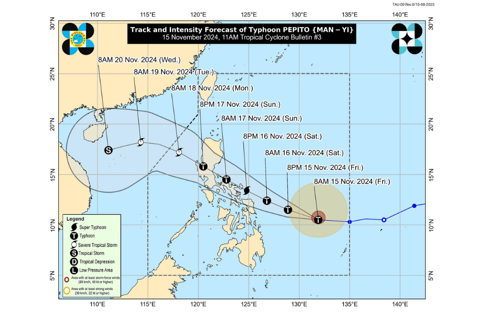
Typhoon #PepitoPH has intensified rapidly as it moves westward over the waters east of Guiuan, Eastern Samar, the Philippine Atmospheric, Geophysical and Astronomical Services Administration (PAGASA) reported.
As of 10:00 a.m. on November 15, 2024, the eye of Typhoon #PepitoPH was located 630 km east of Guiuan, Eastern Samar.
The typhoon is moving at a speed of 30 km/h in a westward direction.
The storm currently has maximum sustained winds of 130 km/h near its center, with gustiness reaching up to 160 km/h and a central pressure of 975 hPa.
Tropical Cyclone Wind Signal No. 2 has been raised over:
- The eastern portion of Northern Samar (Mapanas, Gamay, Palapag, Lapinig)
- The northern portion of Eastern Samar (Arteche, Oras, San Policarpo, Dolores, Jipapad, Maslog)
Tropical Cyclone Wind Signal No. 1 has been raised over:
Luzon:
- The southeastern portion of Quezon
- Camarines Norte
- Camarines Sur
- Catanduanes, Albay
- Sorsogon
- Masbate
Visayas:
- The rest of Northern Samar
- The rest of Eastern Samar
- Samar
- Biliran
Heavy Rainfall Outlook:
Moderate to heavy rainfall (50–100 mm) is expected over Batanes from today until noon tomorrow, November 16.
Coastal Inundation:
There is a moderate to high risk of life-threatening storm surges, with peak heights reaching 3.0 meters above normal tide levels, in the next 48 hours over low-lying or exposed coastal localities of southeastern Quezon, Camarines Sur, Catanduanes, Albay, Sorsogon, northern Masbate (including Burias and Ticao Islands), Northern Samar, Eastern Samar, Samar, and northern Biliran. Residents are advised to monitor Storm Surge Warning No. 2 issued earlier today.
Hazards Affecting Coastal Waters:
While no gale warning is currently in effect, the following sea conditions are expected:
- Very rough to high seas (up to 8.0 m): Eastern seaboard of Eastern Samar and Northern Samar
- Very rough seas (up to 4.5 m): Eastern seaboard of Catanduanes, Albay, and Sorsogon; northern seaboard of Northern Samar
- Sea travel is risky for all vessels. Mariners are advised to remain in port or seek shelter.
Other areas with rough seas:
- Rough seas (up to 4.0 m): Seaboard of Batanes
- Rough seas (up to 3.5 m): Northern and eastern seaboards of Camarines Sur; remaining seaboard of Catanduanes; eastern seaboards of Dinagat Islands and Siargao Islands
- Rough seas (up to 3.0 m): Seaboards of Babuyan Islands and Surigao del Sur
Mariners of small vessels and motorbancas are advised to avoid sea travel under these conditions, especially if inexperienced or operating ill-equipped vessels.
Track and Intensity Outlook:
- #PepitoPH is forecast to move generally west-northwestward over the next five days, with a potential landfall in the vicinity of Catanduanes by tomorrow evening or early Sunday. A landfall along the eastern coast of Camarines Sur, Albay, Sorsogon, Northern Samar, or Quezon/Aurora cannot be ruled out.
- Regardless of the exact landfall location, #PepitoPH will likely continue moving west-northwestward, potentially passing over or near Bicol Region, Quezon, Central Luzon, and Pangasinan before emerging over the West Philippine Sea by Monday morning.
- The typhoon is expected to continue rapid intensification today through tomorrow, possibly reaching super typhoon status prior to landfall. It may weaken slightly over land but is projected to traverse the country as a typhoon and may only downgrade to a severe tropical storm over the West Philippine Sea on Monday.
PAGASA advises the public and local authorities to take all necessary precautions and monitor further advisories as Typhoon #PepitoPH progresses.


