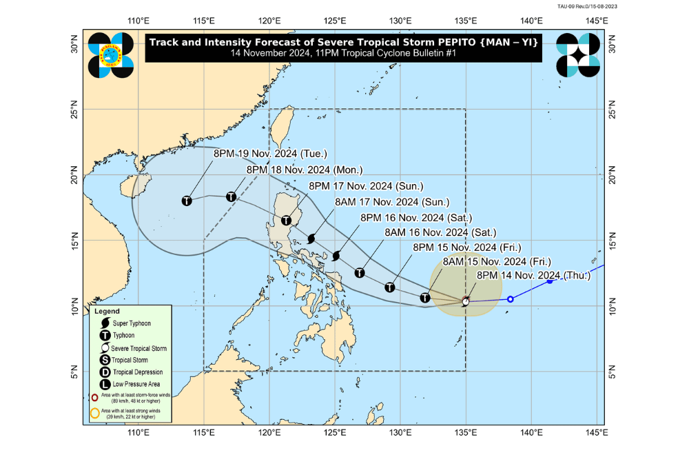
Severe Tropical Storm #PepitoPH has entered the Philippine Area of Responsibility (PAR) and continues to strengthen, according to the Philippine Atmospheric, Geophysical and Astronomical Services Administration (PAGASA).
As of 11:00 p.m. on November 14, 2024, the center of Pepito was estimated to be 945 km east of Eastern Visayas (10.5 °N, 134.4 °E).
The storm is moving westward at a speed of 35 km/h, with maximum sustained winds of 100 km/h near its center and gustiness of up to 125 km/h.
Tropical Cyclone Wind Signal No. 1 has been raised over:
- Luzon:
- Catanduanes
- The eastern portion of Camarines Sur (Caramoan, Garchitorena, Presentacion, San Jose, Lagonoy)
- The eastern portion of Albay (Rapu-Rapu, City of Tabaco, Malilipot, Santo Domingo, Bacacay, Legazpi City, Malinao, Manito, Tiwi)
- The eastern and southern portions of Sorsogon (Juban, City of Sorsogon, Barcelona, Bulusan, Magallanes, Gubat, Santa Magdalena, Casiguran, Bulan, Irosin, Matnog, Prieto Diaz)
- Visayas:
- Northern Samar
- The northern portion of Eastern Samar (San Policarpo, Arteche, Jipapad, Maslog, Dolores, Oras)
- The northeastern portion of Samar (Matuguinao, San Jose de Buan)
Heavy Rainfall Outlook:
While Pepito is not yet directly affecting any part of the country, heavy rainfall is expected due to the storm and enhanced by the ongoing effects of Typhoon Ofel. PAGASA has issued Weather Advisory No. 34 at 11:00 p.m. today in anticipation of the rain.
Coastal Inundation:
Storm surge warnings may be raised over the coastal waters of Aurora, Quezon, Bicol Region, and Eastern Visayas in the coming hours.
Hazards Affecting Coastal Waters:
- Gale Warning:
- A gale warning has been issued for the northern and eastern seaboards of Northern Luzon and the eastern seaboard of Central Luzon. Refer to Gale Warning No. 5A issued at 11:00 p.m. today for more details.
24-Hour Sea Condition Outlook:
- Up to very rough or high seas (up to 8.0 m):
- The seaboards of Batanes and Babuyan Islands
- The northern seaboards of Ilocos Norte and mainland Cagayan
- Up to rough seas (up to 7.0 m):
- The northern seaboards of Ilocos Norte and mainland Cagayan
- The eastern seaboard of mainland Cagayan
- Sea travel is risky for all types of vessels. Mariners are advised to seek shelter or remain in port.
- Up to rough seas (up to 4.0 m):
- The seaboards of Isabela and northern Aurora
- Mariners of small seacrafts, including motorbancas, should refrain from venturing out to sea.
- Up to moderate seas (up to 2.5 m):
- The western seaboard of Ilocos Norte; the northern and eastern seaboards of Catanduanes and Northern Samar; the eastern seaboards of Albay, Sorsogon, Eastern Samar, Dinagat Islands, Surigao del Norte including Siargao and Bucas Grande Islands, Surigao del Sur, and Davao Oriental
- Mariners should take precautionary measures and avoid navigation where possible.
Track and Intensity Outlook:
Pepito is forecast to continue moving westward and may turn west-northwestward to northwestward over the Philippine Sea. The storm is expected to pass near Eastern Visayas and Bicol Region. Pepito may make landfall over the eastern coast of Central Luzon during the weekend (November 16 or 17). The track may shift within the forecast confidence cone, meaning landfall could also occur in Eastern Visayas.
Pepito is forecast to intensify into a typhoon by November 15 and could reach super typhoon status by November 16. It may make landfall at its peak intensity and weaken slightly due to land interaction before exiting the Philippine Area of Responsibility (PAR) by November 18.
PAGASA urges the public to stay updated on further advisories and take necessary precautions.


