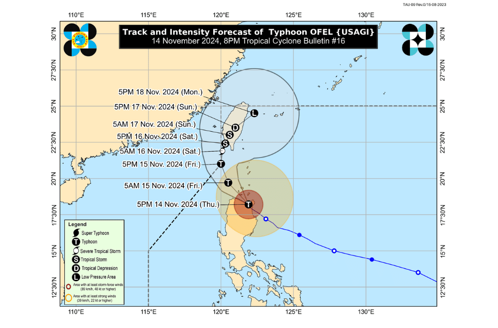
Typhoon #OfelPH further weakened while passing through the Babuyan Islands, according to the Philippine Atmospheric, Geophysical and Astronomical Services Administration (PAGASA).
As of 11:00 p.m. on November 14, 2024, the center of "Ofel" was located over the coastal waters of Calayan, Cagayan.
The storm is moving northwestward at a speed of 15 km/h.
Currently, "Ofel" has maximum sustained winds of 130 km/h near its center, with gusts reaching up to 200 km/h.
Tropical Cyclone Wind Signal No. 4 has been raised over:
- The northern portion of Cagayan (Santa Teresita, Ballesteros, Aparri, Camalaniugan, Buguey, Gonzaga, Santa Ana, Abulug, Pamplona, Sanchez-Mira, Claveria, Santa Praxedes, Lal-Lo, Allacapan) including Babuyan Islands
Tropical Cyclone Wind Signal No. 3 has been raised over:
- The southern portion of Batanes (Basco, Mahatao, Ivana, Uyugan, Sabtang)
- The central and southeastern portions of mainland Cagayan (Lasam, Alcala, Amulung, Iguig, Santo Niño, Rizal, Piat, Peñablanca, Baggao, Gattaran)
- The northern and central portions of Apayao (Flora, Pudtol, Kabugao, Calanasan, Luna, Santa Marcela)
- The northern portion of Ilocos Norte (Adams, Dumalneg, Bangui, Pagudpud, Pasuquin, Burgos, Vintar, Carasi)
Tropical Cyclone Wind Signal No. 2 has been raised over:
- The rest of Batanes
- The rest of Cagayan
- The northern portion of Isabela (Quezon, Delfin Albano, Tumauini, Maconacon, Cabagan, San Pablo, Santo Tomas, Santa Maria)
- The rest of Apayao
- The northern portion of Kalinga (Pinukpuk, Rizal, City of Tabuk, Balbalan)
- The northern portion of Abra (Tineg, Lacub, Malibcong, Lagayan, San Juan, Lagangilang, Licuan-Baay, Daguioman)
- The rest of Ilocos Norte
Tropical Cyclone Wind Signal No. 1 has been raised over:
- The rest of Isabela
- The northeastern portion of Quirino (Maddela)
- The rest of Abra
- The rest of Kalinga
- Mountain Province
- The northern portion of Ifugao (Aguinaldo, Banaue, Mayoyao, Hingyon, Hungduan, Lagawe, Kiangan, Alfonso Lista)
- The northern and central portions of Ilocos Sur (Sinait, Cabugao, San Juan, San Ildefonso, Magsingal, Santo Domingo, Bantay, San Vicente, City of Vigan, Caoayan, Santa Catalina, Santa, Nagbukel, Narvacan, Gregorio del Pilar, San Esteban, Banayoyo, Cervantes, Burgos, City of Candon, Santa Lucia, Santiago, Lidlidda, Suyo, Sigay, Galimuyod, Quirino, San Emilio, Santa Cruz, Santa Maria, Salcedo)
- The northern portion of Aurora (Casiguran, Dilasag)
Heavy Rainfall Outlook: From tonight to tomorrow evening (November 15):
- Heavy to Intense (100 – 200 mm) rain is expected over Batanes, Cagayan, Ilocos Norte, and Apayao.
- Moderate to Heavy (50 – 100 mm) rain is expected over Abra, Kalinga, Mountain Province, and Isabela.
Coastal Inundation: A high risk of life-threatening storm surge with peak heights exceeding 3.0 m is expected over the coastal localities of Batanes, Ilocos Norte, Ilocos Sur, Cagayan (including Babuyan Islands), Isabela, and northern Aurora. Residents in these areas are advised to refer to Storm Surge Warning No. 10 issued at 8:00 PM today for more details.
Hazards Affecting Coastal Waters: A Gale Warning is in effect for the northern and eastern seaboards of Northern Luzon. Refer to Gale Warning No. 5A issued at 11:00 PM today.
24-Hour Sea Condition Outlook:
- Very rough to high seas (up to 8.0 m): Seaboards of Batanes and Babuyan Islands.
- Up to 7.0 m: Northern seaboards of Ilocos Norte and mainland Cagayan.
- Up to 5.5 m: Eastern seaboard of mainland Cagayan.
- Up to 4.0 m: Seaboards of Isabela and northern Aurora.
- Up to moderate seas (up to 2.5 m): Western seaboard of Ilocos Norte; northern and eastern seaboards of Catanduanes and Northern Samar; eastern seaboards of Albay, Sorsogon, Eastern Samar, Dinagat Islands, Surigao del Norte including Siargao and Bucas Grande Islands, Surigao del Sur, and Davao Oriental.
- Up to 2.0 m: Remaining seaboard of Aurora; eastern seaboard of Quezon (including Polillo Islands); seaboard of Camarines Norte; northern and eastern seaboards of Camarines Sur; remaining seaboard of Catanduanes.
Track and Intensity Outlook: Typhoon "Ofel" is expected to continue its northwestward movement and pass close to or make landfall in the vicinity of Babuyan Islands tonight before turning north northwestward to northward over the sea west of Batanes. By Saturday morning, it will likely exit the Philippine Area of Responsibility (PAR).


