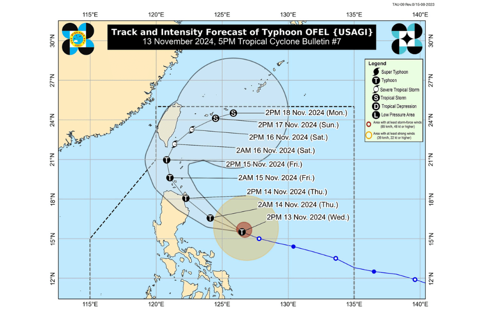
Typhoon #OfelPH has intensified as it moves west-northwestward over the Philippine Sea, posing a threat to Northern Luzon, according to the Philippine Atmospheric, Geophysical and Astronomical Services Administration (PAGASA).
As of 5:00 p.m. on November 13, 2024, the center of #OfelPH was located approximately 480 km east of Baler, Aurora.
The typhoon is moving at a speed of 25 km/h in a west-northwestward direction.
The storm currently has maximum sustained winds of 120 km/h near its center, with gustiness reaching up to 150 km/h.
Tropical Cyclone Wind Signal No. 2 has been raised over:
- Cagayan, including Babuyan Islands
- The northern and eastern portions of Isabela (Maconacon, Divilacan, Palanan, San Pablo, Cabagan, Santa Maria, Santo Tomas, Tumauini, Ilagan City)
- The eastern portion of Apayao (Flora, Luna, Santa Marcela, Pudtol)
Tropical Cyclone Wind Signal No. 1 has been raised over:
- Batanes
- The rest of Isabela
- Quirino
- The northern portion of Nueva Vizcaya (Kasibu, Ambaguio, Solano, Bayombong, Quezon, Bagabag, Diadi, Villaverde)
- Apayao
- Kalinga
- Abra
- Mountain Province
- Ifugao
- Ilocos Norte
- The northern portion of Aurora (Dilasag, Casiguran, Dinalungan, Dipaculao)
Severe Winds:
The wind signals indicate the general wind threat over affected areas due to the tropical cyclone. Winds may be slightly stronger or enhanced in coastal and mountainous areas, while sheltered areas may experience less intensity.
- Wind Signal No. 2: Minor to moderate impacts from strong winds are possible.
- Wind Signal No. 1: Minimal to minor impacts from strong winds are possible.
The highest Wind Signal expected during Typhoon Ofel’s passage is Wind Signal No. 4.
Coastal Inundation:
There is a moderate to high risk of life-threatening storm surge, with heights reaching 1.0 to 3.0 meters in the next 48 hours along low-lying coastal areas in the following regions:
- Batanes
- Ilocos Norte
- Ilocos Sur
- Cagayan, including Babuyan Islands
- Isabela
- Northern Aurora
Hazards Affecting Coastal Waters:
24-Hour Sea Condition Outlook
- Up to 10.0 m: Eastern seaboard of mainland Cagayan; seaboard of Babuyan Islands
- Up to 8.0 m: Seaboards of Isabela; remaining seaboard of mainland Cagayan
- Up to 5.0 m: Seaboard of northern Aurora
Sea travel is deemed risky for all types and sizes of vessels in these conditions. Mariners are advised to remain in port or seek safe harbor immediately until sea conditions improve.
- Up to 4.5 m: Seaboard of Batanes
- Up to 3.5 m: Northern and eastern seaboards of Catanduanes, Polillo Islands, and the remaining seaboard of Aurora; seaboard of Camarines Norte and northern Quezon; northern seaboards of Ilocos Norte and Camarines Sur
- Mariners, particularly those with small vessels, are advised against sea travel.
- Up to 2.5 m: Eastern seaboard of mainland Quezon, including the rest of Polillo Islands, Albay, and Sorsogon; northern and eastern seaboards of Northern Samar
- Up to 2.0 m: Remaining seaboard of the Ilocos Region; seaboard of Kalayaan Islands; eastern seaboard of Camarines Sur and Eastern Samar; remaining seaboard of Catanduanes
- Mariners operating small vessels should take precautionary measures and avoid navigation if possible.
Track and Intensity Outlook:
#OfelPH is expected to move west-northwestward to northwestward over the Philippine Sea and is forecast to make landfall along the eastern coast of Cagayan or Isabela on November 14. After landfall, it will likely move across Northern Luzon, passing near or over the Babuyan Islands, and then turn northeastward towards the sea east of Taiwan on November 16.
The typhoon is projected to steadily intensify before landfall, potentially reaching its peak strength. Weakening is expected after landfall as it continues across Luzon.
PAGASA advises the public to monitor further updates and take necessary precautions as #OfelPH progresses.


