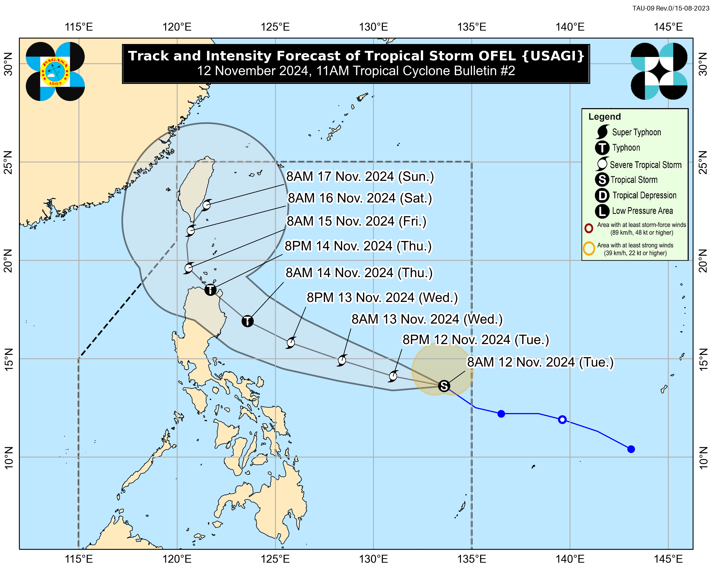
Severe Tropical Storm #OfelPH has strengthened further over the Philippine Sea while continuing its west-northwestward movement, according to the Philippine Atmospheric, Geophysical and Astronomical Services Administration (PAGASA).
As of 5:00 p.m. on November 12, 2024, the center of #OfelPH was located 780 km east of Virac, Catanduanes.
The storm is moving at a speed of 30 km/h in a west-northwestward direction.
Currently, it has maximum sustained winds of 95 km/h near its center, with gustiness reaching up to 115 km/h.
Tropical Cyclone Wind Signal
No Tropical Cyclone Wind Signal has been raised yet; however, PAGASA advises that TCWS No. 1 may be raised over portions of Cagayan Valley later this evening or early tomorrow morning. The highest possible Wind Signal during #OfelPH's occurrence could reach up to TCWS No. 4.
Heavy Rainfall Outlook
PAGASA has warned of heavy rainfall associated with #OfelPH:
- Tomorrow afternoon to Thursday afternoon (November 14):
- Heavy to Intense (100-200 mm): Isabela
- Moderate to Heavy (50-100 mm): Abra, Apayao, Aurora, Cagayan, Ifugao, Kalinga, Mountain Province
Severe Winds
Strong to gale-force gusts are expected in coastal and upland areas under #OfelPH's circulation:
- November 13: Catanduanes
- November 14: Quezon, northern portions of Camarines Norte, Camarines Sur, Catanduanes
- November 15: Eastern Isabela, northern Aurora
Coastal Inundation
PAGASA forecasts a minimal to moderate risk of storm surge, with peak heights of 1.0 to 2.0 meters over eastern mainland Cagayan, Isabela, and northern Aurora in the next 48 hours.
Hazards Affecting Coastal Waters
Up to rough seas are expected over certain coastal waters, prompting warnings for mariners and small vessels:
- Up to 3.0 m: Western seaboard of Batanes, Babuyan Islands, seaboard of Ilocos Norte
- Up to 2.5 m: Remaining seaboards of Batanes, Babuyan Islands, Ilocos Region; northern seaboard of mainland Cagayan; northern and eastern seaboards of Catanduanes
- Up to 2.0 m: Remaining seaboard of Cagayan Valley, western seaboard of Zambales; seaboards of northern Aurora, Kalayaan Islands, northern and eastern seaboards of Camarines Sur, Northern Samar; eastern seaboards of Albay, Sorsogon, Eastern Samar
Mariners are advised to avoid navigating in these conditions, especially those with smaller vessels.
Track and Intensity Outlook
#OfelPH is forecast to move west-northwestward over the Philippine Sea and may make landfall along the east coast of Cagayan or Isabela on Thursday afternoon or evening. It will then likely shift to a more northwestward direction by Friday, slowing down and possibly behaving erratically over the weekend.
PAGASA emphasizes that land and coastal hazards could still impact areas outside the current forecast track. The storm is expected to reach typhoon status by tomorrow evening, possibly making landfall at its peak intensity.


