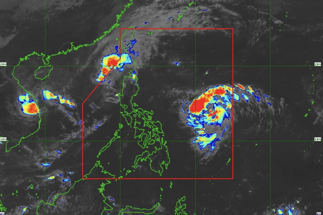
Tropical Storm (TS) "Ofel" (international name: Usagi) intensifies slightly as it moves northwestward over the Philippine Sea, according to PAGASA advisory issued at 11 a.m. on Tuesday, November 12, 2024.
As of 10 a.m., the center of TS Ofel was estimated based on all available data at 950 km east of southeastern Luzon (13.8°N, 133.0°E).
• Intensity
Maximum sustained winds of 85 km/h near the center, gustiness of up to 105 km/h, and central pressure of 996 hPa
• Present Movement
Northwestward at 35 km/h
• Extent of Tropical Cyclone Winds
Strong to gale-force winds extend outwards up to 230 km from the center
TROPICAL CYCLONE WIND SIGNALS (TCWS) IN EFFECT
• No Wind Signal hoisted currently
OTHER HAZARDS AFFECTING LAND AREAS
○ Heavy Rainfall Outlook
Currently, TS Ofel is not directly affecting any part of the country. However, Weather Advisory No. 19 has been issued in anticipation of the heavy rainfall caused by OFEL.
○ Severe Winds
Tropical Cyclone Wind Signal No. 1 may be raised over portions of Cagayan Valley late evening of November 12, 2024 or early morning on November 13, 2024. The highest Wind Signal which may be hoisted during the occurrence of TS Ofel is Wind Signal No. 4.
Furthermore, the wind flow coming towards the circulation of TS Ofel will also bring strong to gale-force gusts over the following areas (especially in coastal and upland areas exposed to winds):
• November 13, 2024: Catanduanes
• November 14, 2024: Batanes, Quezon including Polillo Islands, Camarines Norte, and the northern portions of Camarines Sur, and Catanduanes
• November 15, 2024: Isabela and the northern portion of Aurora
HAZARDS AFFECTING COASTAL WATERS
○ 24-Hour Sea Condition Outlook
Up to very rough or high seas over the following coastal waters:
• Up to 4.0 m: The seaboards of Ilocos Norte and northern Ilocos Sur
• Sea travel is risky for all types or tonnage of vessels. All mariners must remain in port or, if underway, seek shelter or safe harbor as soon as possible until winds and waves subside.
Up to rough seas over the following coastal waters:
• Up to 3.5 m: The seaboards of Batanes and Cagayan including Babuyan Islands
• Up to 3.0 m: The remaining seaboard of Ilocos Region, and the seaboard of northern Isabela
• Mariners of small seacrafts, including all types of motorbancas, are advised not to venture out to sea under these conditions, especially if inexperienced or operating ill-equipped vessels.
Up to moderate seas over the following coastal waters:
• Up to 2.0 m: The remaining western and eastern seaboards of Luzon; the eastern seaboards of Visayas and Mindanao
• Mariners of motorbancas and similarly-sized vessels are advised to take precautionary measures while venturing out to sea and, if possible, avoid navigation under these conditions.
TRACK AND INTENSITY OUTLOOK
• TS Ofel is forecast to move west northwestward until Thursday, November 14, 2024 evening before turning northwestward to northward for the rest of the forecast period. On the forecast track, TS Ofel may make landfall over Northern or Central Luzon on Thursday, November 14, 2024, afternoon or evening.
• This tropical cyclone is forecast to steadily intensify in the next three days and reach typhoon category on November 13, 2024 evening or early morning on November 14, 2024. TS Ofel may reach its peak intensity prior to landfall.
• Regardless of the position of the landfall point, it must be emphasized that hazards on land and coastal waters may still be experienced in areas outside the landfall point or forecast confidence cone. It must also be emphasized that the track may still shift within the limit of the forecast confidence cone, especially on the 4th and 5th day of the forecast track.
• Although it is too early to exactly determine the specific areas to be affected by certain hazards, areas in Northern Luzon are at risk of heavy rainfall, severe wind, and, possibly, storm surge inundation from TS Ofel which may cause considerable impacts. Moreover, the eastern portions of Central and Southern Luzon may also be affected, especially if the tropical cyclone further expands in size or follows a more southerly path (but within the forecast confidence cone).
Considering these developments, the public and disaster risk reduction and management offices concerned are advised to continue monitoring for updates related to this tropical cyclone.
(Info courtesy: DOST-PAGASA)


