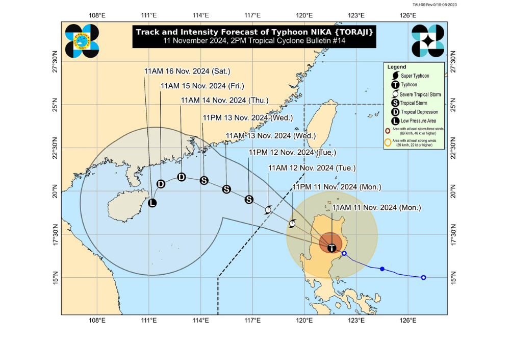
Typhoon #NikaPH (TORAJI) has intensified and is currently moving west northwestward over the Cordillera Administrative Region, according to the Philippine Atmospheric, Geophysical and Astronomical Services Administration (PAGASA).
As of 1:00 p.m. on November 11, 2024, the center of #NikaPH was located near Lagawe, Ifugao (16.8°N, 121.2°E).
The typhoon is moving at a speed of 25 km/h in a west northwestward direction.
The storm has maximum sustained winds of 130 km/h near its center, with gustiness reaching up to 215 km/h.
Tropical Cyclone Wind Signal No. 4 has been raised over:
- The northernmost portion of Aurora (Dilasag, Casiguran)
- The central and southern portions of Isabela (Dinapigue, San Mariano, San Guillermo, Jones, Echague, Ramon, San Isidro, City of Santiago, Cordon, Roxas, Burgos, Reina Mercedes, Naguilian, Benito Soliven, Gamu, San Manuel, Aurora, San Mateo, Cabatuan, Alicia, Luna, City of Cauayan, Angadanan, Quezon, Mallig, Quirino, Ilagan City, Delfin Albano, San Agustin)
- Kalinga
- Mountain Province
- The northern portion of Ifugao (Aguinaldo, Mayoyao, Alfonso Lista, Banaue, Hungduan, Hingyon, Lagawe)
- The central and southern portion of Abra (Manabo, Pidigan, San Juan, Tayum, Langiden, Luba, Boliney, Sallapadan, Bucloc, Lagangilang, Tubo, Danglas, Villaviciosa, La Paz, Licuan-Baay, Pilar, Malibcong, Pe, San Isidro, Daguioman, San Quintin, Dolores, Lagayan, Bangued, Bucay, Lacub)
- The northern and central portions of Ilocos Sur (Cabugao, Sinait, San Juan, San Emilio, Lidlidda, Banayoyo, Santiago, San Esteban, Burgos, Santa Maria, Magsingal, San Vicente, Santa Catalina, Nagbukel, San Ildefonso, City of Vigan, Caoayan, Santa, Bantay, Santo Domingo, Narvacan, Quirino, Cervantes, Sigay, Salcedo, Santa Lucia, City of Candon, Galimuyod, Gregorio del Pilar, Santa Cruz)
Tropical Cyclone Wind Signal No. 3 has been raised over:
- The central portion of Aurora (Dinalungan)
- The northern portion of Quirino (Diffun, Cabarroguis, Aglipay, Saguday, Maddela)
- The northeastern portion of Nueva Vizcaya (Diadi, Bagabag, Quezon, Solano, Villaverde, Kasibu, Ambaguio, Bayombong)
- The rest of Isabela
- The southwestern portion of Cagayan (Enrile, Solana, Tuao, Tuguegarao City, Rizal, Piat)
- The southern portion of Apayao (Conner, Kabugao)
- The rest of Abra
- The rest of Ifugao
- The northern portion of Benguet (Buguias, Mankayan, Bakun)
- The southern portion of Ilocos Norte (Laoag City, Sarrat, San Nicolas, Piddig, Marcos, Nueva Era, Dingras, Bacarra, Solsona, Paoay, Currimao, Pinili, Badoc, City of Batac, Banna)
- The rest of Ilocos Sur
Tropical Cyclone Wind Signal No. 2 has been raised over:
- The northwestern and eastern portions of Cagayan (Iguig, Peñablanca, Baggao, Alcala, Amulung, Santo Niño, Gattaran, Lasam, Santa Praxedes, Claveria, Sanchez-Mira, Pamplona, Abulug, Allacapan, Ballesteros, Lal-Lo, Aparri, Camalaniugan, Buguey, Santa Teresita, Gonzaga)
- The rest of Nueva Vizcaya
- The rest of Quirino
- The rest of Apayao
- The rest of Benguet
- The rest of Ilocos Norte
- La Union
- The northeastern portion of Pangasinan (San Nicolas, Natividad, San Quintin, Sison, San Manuel, Umingan, Tayug)
- The central portion of Aurora (Dipaculao, Maria Aurora, Baler)
- The northern portion of Nueva Ecija (Carranglan, Pantabangan, Lupao, San Jose City)
Tropical Cyclone Wind Signal No. 1 has been raised over:
- Babuyan Islands
- The rest of mainland Cagayan
- The rest of Pangasinan
- The rest of Aurora
- The rest of Nueva Ecija
- Bulacan
- Pampanga
- Tarlac
- The northern and central portions of Zambales (Santa Cruz, Candelaria, Masinloc, Palauig, Iba, Botolan, Cabangan, San Marcelino, San Felipe, San Narciso)
- The northern portion of Metro Manila (City of Navotas, City of Valenzuela, City of Malabon, Caloocan City, City of Marikina, City of Pasig, Quezon City, City of Manila, City of Makati, Pateros, City of San Juan, City of Mandaluyong)
- The northern portion of Rizal (Rodriguez, Teresa, City of Antipolo, San Mateo, Morong, Baras, Cainta, Tanay, Taytay, Angono)
- The northeastern portion of Quezon (Infanta, General Nakar) including Pollilo Islands
Heavy Rainfall Outlook (Today to Tomorrow Noon - November 12):
- Intense to Torrential Rain (over 200 mm): Aurora, Isabela, Cagayan, Abra, Quirino, Nueva Vizcaya, Benguet, Ifugao, Mountain Province, Kalinga, and Apayao.
- Heavy to Intense Rain (100-200 mm): Ilocos Norte, Ilocos Sur, and La Union.
- Moderate to Heavy Rain (50-100 mm): Nueva Ecija, Tarlac, and Pangasinan.
Rainfall may be heavier in mountainous areas, and some regions could experience worsened conditions due to previous heavy rainfall.
Severe Winds:
- Wind Signal No. 4: Areas may face significant to severe impacts from typhoon-force winds.
- Wind Signal No. 3: Moderate to significant impacts from storm-force winds are possible.
- Wind Signal No. 2: Minor to moderate impacts from gale-force winds are possible.
- Wind Signal No. 1: Minimal to minor impacts from strong winds are possible.
Strong to gale-force gusts are expected today (Nov. 11) in Batanes, Bataan, Cavite, Batangas, Lubang Island, Marinduque, Romblon, Masbate, Camarines Norte, Camarines Sur, and Catanduanes, and tomorrow (Nov. 12) in Ilocos Sur, La Union, Pangasinan, Batanes, Cagayan (including Babuyan Islands), and Isabela.
Coastal Inundation: There is a moderate to high risk of storm surge over the next 48 hours, especially in low-lying or coastal areas in Ilocos Norte, Ilocos Sur, La Union, Pangasinan, Cagayan, Isabela, Zambales, and Aurora.
Coastal Waters Hazards:
- Gale Warning: Issued for the eastern seaboard of Luzon and northern/western seaboards of Northern Luzon.
- Sea Conditions: Up to very rough seas (5.5 m) along the eastern Cagayan coast, Isabela, Ilocos Sur, and parts of Ilocos Norte. Mariners are advised to avoid sea travel in these areas.
- Rough Seas: Other coastal areas of Northern Luzon, including Batanes, should expect up to 4 m high waves.
- Moderate Seas: Coastal waters in parts of Quezon, Camarines Norte, and other areas may have up to 2.5 m high waves.
Track and Intensity Outlook: #NikaPH will cross mainland Luzon today, weakening as it interacts with land. It will emerge over the West Philippine Sea by this afternoon or evening, moving west-northwest towards the Philippine Sea, exiting the area by tomorrow morning. NIKA may continue to weaken and become a remnant low near southern China by Friday (Nov. 15).


