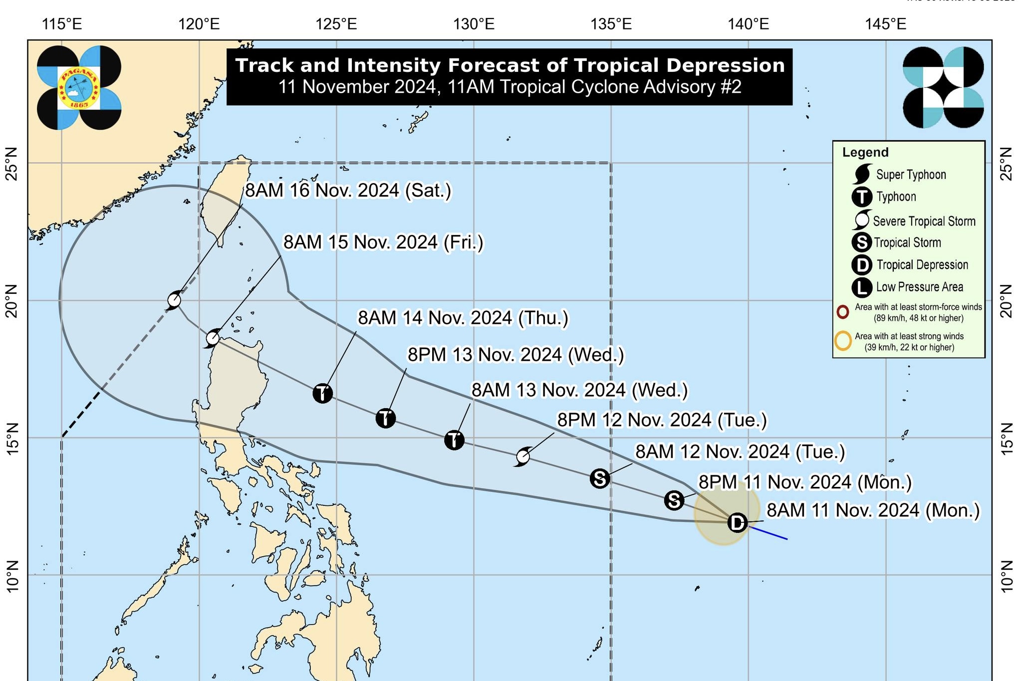
The tropical depression spotted outside of the Philippine Area of Responsibility (PAR) continues to "intensify as it moves west northwestward at a fast pace," said PAGASA advisory issued at 11 a.m. on Monday, November 11, 2024.
As of 10 a.m., the center of the tropical depression was estimated based on all available data at 1,480 km East of Eastern Visayas (outside PAR) (12.1°N, 139.3°E).
Intensity:
Maximum sustained winds of 55 km/h near the center, gustiness of up to 70 km/h, and central pressure of 1002 hPa
Present Movement:
West northwestward at 35 km/h
Extent of Tropical Cyclone Winds
Strong winds extend outwards up to 190 km from the center
GENERAL OUTLOOK FOR THE FORECAST PERIOD
• The tropical depression (TD) will move steadily west northwestward and enter the Philippine Area of Responsibility (PAR) morning on November 12, 2024 as "Ofel."
Within the PAR region, this tropical cyclone will continue moving west northwestward. On the forecast track, the TD may make landfall over Northern or Central Luzon evening on November 14, 2024, or early morning on Friday, November 15, 2024.
• This tropical cyclone is forecast to intensify steadily in the next three days and reach typhoon category on Wednesday, November 13, 2024. It may also hit land at or near its peak intensity.
• Regardless of the position of the landfall point, it must be emphasized that hazards on land and coastal waters may still be experienced in areas outside the landfall point or forecast confidence cone. It must also be emphasized that the track may still shift within the limit of the forecast confidence cone, especially on the 4th and 5th day of the forecast track.
• Although it is too early to exactly determine the specific areas to be affected by certain hazards, areas in Northern Luzon are at risk of heavy rainfall, severe wind, and, possibly, storm surge inundation from this tropical cyclone which may cause considerable impacts. Furthermore, the eastern portions of Central and Southern Luzon may also be further affected, especially if the tropical cyclone further expands in size or follows a path south of the more likely path (but within the forecast confidence cone).
• This tropical cyclone may bring potentially risky or hazardous sea conditions (at least moderate to rough or worse) over the northern and eastern seaboards of Bicol Region and the eastern seaboard of Eastern Visayas beginning on mid-Wednesday, November 13, 2024. The same conditions may be experienced over the seaboard of Northern Luzon and the eastern seaboard of Central Luzon from late Wednesday, November 13, 2024, to early Saturday, November 16, 2024.
Considering these developments, the public and disaster risk reduction and management offices concerned are advised to continue monitoring for updates related to this tropical cyclone, DOST-PAGASA further said.


