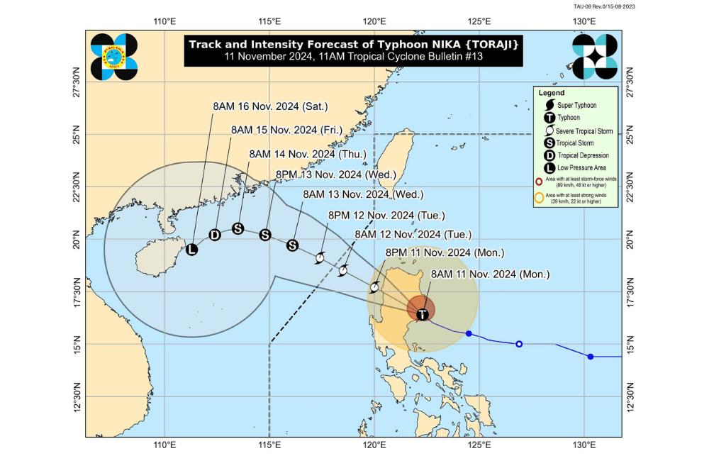
Typhoon #NikaPH has made landfall over Dilasag, Aurora, and is now traversing northern Luzon, according to the Philippine Atmospheric, Geophysical and Astronomical Services Administration (PAGASA).
As of 10:00 AM on November 11, 2024, the center of Typhoon #NikaPH was located in the vicinity of San Agustin, Isabela (16.5°N, 121.8°E).
The storm is moving northwestward at 25 km/h.
The storm currently has maximum sustained winds of 130 km/h near its center, with gustiness reaching up to 180 km/h. Its central pressure is 965 hPa.
Tropical Cyclone Wind Signal (TCWS) No. 4 has been raised over:
- The northernmost portion of Aurora (Dilasag, Casiguran)
- The central and southern portions of Isabela (Dinapigue, San Mariano, San Guillermo, Jones, Echague, Ramon, San Isidro, City of Santiago, Cordon, Roxas, Burgos, Reina Mercedes, Naguilian, Benito Soliven, Gamu, San Manuel, Aurora, San Mateo, Cabatuan, Alicia, Luna, City of Cauayan, Angadanan, Quezon, Mallig, Quirino, Ilagan City, Delfin Albano, San Agustin)
- Kalinga
- Mountain Province
- The northern portion of Ifugao (Aguinaldo, Mayoyao, Alfonso Lista, Banaue, Hungduan, Hingyon, Lagawe)
- The central and southern portion of Abra (Manabo, Pidigan, San Juan, Tayum, Langiden, Luba, Boliney, Sallapadan, Bucloc, Lagangilang, Tubo, Danglas, Villaviciosa, La Paz, Licuan-Baay, Pilar, Malibcong, Pe, San Isidro, Daguioman, San Quintin, Dolores, Lagayan, Bangued, Bucay, Lacub)
- The northern and central portions of Ilocos Sur (Cabugao, Sinait, San Juan, San Emilio, Lidlidda, Banayoyo, Santiago, San Esteban, Burgos, Santa Maria, Magsingal, San Vicente, Santa Catalina, Nagbukel, San Ildefonso, City of Vigan, Caoayan, Santa, Bantay, Santo Domingo, Narvacan, Quirino, Cervantes, Sigay, Salcedo, Santa Lucia, City of Candon, Galimuyod, Gregorio del Pilar, Santa Cruz)
Tropical Cyclone Wind Signal No. 3 has been raised over:
- The central portion of Aurora (Dinalungan)
- The northern portion of Quirino (Diffun, Cabarroguis, Aglipay, Saguday, Maddela)
- The northeastern portion of Nueva Vizcaya (Diadi, Bagabag, Quezon, Solano, Villaverde, Kasibu, Ambaguio, Bayombong)
- The rest of Isabela
- The southwestern portion of Cagayan (Enrile, Solana, Tuao, Tuguegarao City, Rizal, Piat)
- The southern portion of Apayao (Conner, Kabugao)
- The rest of Abra
- The rest of Ifugao
- The northern portion of Benguet (Buguias, Mankayan, Bakun)
- The southern portion of Ilocos Norte (Laoag City, Sarrat, San Nicolas, Piddig, Marcos, Nueva Era, Dingras, Bacarra, Solsona, Paoay, Currimao, Pinili, Badoc, City of Batac, Banna)
- The rest of Ilocos Sur
Tropical Cyclone Wind Signal No. 2 has been raised over:
- The northwestern and eastern portions of Cagayan (Iguig, Peñablanca, Baggao, Alcala, Amulung, Santo Niño, Gattaran, Lasam, Santa Praxedes, Claveria, Sanchez-Mira, Pamplona, Abulug, Allacapan, Ballesteros, Lal-Lo, Aparri, Camalaniugan, Buguey, Santa Teresita, Gonzaga)
- The rest of Nueva Vizcaya
- The rest of Quirino
- The rest of Apayao
- The rest of Benguet
- The rest of Ilocos Norte
- La Union
- The northeastern portion of Pangasinan (San Nicolas, Natividad, San Quintin, Sison, San Manuel, Umingan, Tayug)
- The central portion of Aurora (Dipaculao, Maria Aurora, Baler)
- The northern portion of Nueva Ecija (Carranglan, Pantabangan, Lupao, San Jose City)
Tropical Cyclone Wind Signal No. 1 has been raised over:
- Babuyan Islands
- The rest of mainland Cagayan
- The rest of Pangasinan
- The rest of Aurora
- The rest of Nueva Ecija
- Bulacan
- Pampanga
- Tarlac
- The northern and central portions of Zambales (Santa Cruz, Candelaria, Masinloc, Palauig, Iba, Botolan, Cabangan, San Marcelino, San Felipe, San Narciso)
- Metro Manila
- Rizal
- The eastern portion of Laguna (Santa Maria, Mabitac, Pakil, Pangil, Famy, Siniloan, Paete, Kalayaan, Cavinti, Lumban, Luisiana, Santa Cruz, Magdalena, Pagsanjan, Pila)
- The northern and eastern portions of Quezon (Infanta, Sampaloc, Mauban, Real, General Nakar) including Polillo Islands
Rainfall Outlook:
- Intense to Torrential Rain (over 200 mm): Expected in Aurora, Isabela, Cagayan, Quirino, Nueva Vizcaya, Benguet, Ifugao, Mountain Province, Kalinga, and Apayao.
- Heavy to Intense Rain (100-200 mm): Forecast for Abra, Ilocos Norte, Ilocos Sur, and La Union.
- Moderate to Heavy Rain (50-100 mm): Expected in Quezon, Nueva Ecija, Tarlac, and Pangasinan.
Wind and Storm Warnings:
- Wind Signal No. 4 warns of potential significant to severe impacts from typhoon-force winds.
- Wind Signal No. 3 suggests moderate to significant impacts from storm-force winds.
- Wind Signal No. 2 indicates possible minor to moderate impacts from gale-force winds.
- Wind Signal No. 1 predicts minimal to minor impacts from strong winds.
Coastal Inundation:
- Moderate to High Risk of Storm Surge: This affects coastal areas in Ilocos Norte, Ilocos Sur, La Union, Pangasinan, Cagayan, Isabela, Zambales, Aurora, Quezon (including Polillo Islands), Camarines Norte, and Camarines Sur.
Coastal Hazards:
- Gale Warning: Mariners are advised to avoid sea travel as rough seas, ranging from 2.0 meters to 8.0 meters, are expected, particularly over the eastern seaboard of Luzon and Northern Luzon.
- Sea Travel Advisory: Mariners should take precautionary measures and remain in port or seek shelter until conditions improve.
Cyclone Track and Intensity:
- NIKA is expected to weaken as it moves across Luzon today, emerging over the West Philippine Sea later today. It will continue moving west northwestward before exiting the Philippine Area of Responsibility by tomorrow. While it may weaken into a severe tropical storm, it is likely to continue weakening until becoming a remnant low over southern China by Friday.


