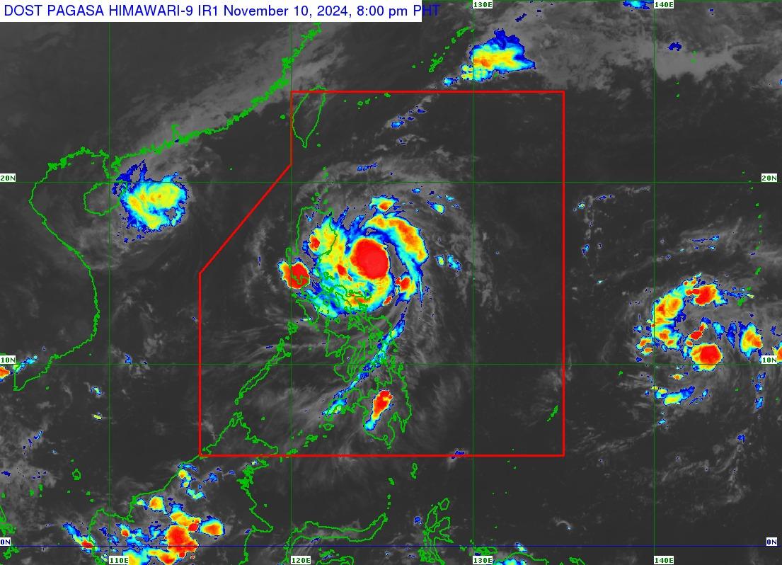
Signal No. 3 was hoisted in two areas in northern Luzon as Severe Tropical Storm Nika decelerates slightly over the Philippine Sea east of Aurora, PAGASA said evening on Sunday, November 10, 2024.
According to the 8 p.m. PAGASA tropical cyclone bulletin, Nika has maximum sustained winds of 110 km/h near the center and gustiness of up to 135 km/h.
Areas under Signal No. 3 are:
- the southeastern portion of Isabela (Dinapigue, Palanan) and
- the northern portion of Aurora (Dilasag, Casiguran, Dinalungan)
Affected areas may experience winds of greater than 89 km/h up to 117 km/h in at least 18 hours, which may cause heavy damage to high–risk structures.
Nika is expected to reach typhoon category on Sunday and may reach its peak intensity prior to landfall.
“A short period of weakening is expected as NIKA traverses the landmass of Luzon due to land interaction. Re-intensification may occur over the West Philippine Sea,” the state weather bureau said.
Nika is also seen to move generally west northwestward throughout the forecast period and may make landfall over Isabela or Aurora on Monday morning or early afternoon.
It will then traverse the landmass of mainland northern Luzon and emerge over the West Philippine Sea on Monday evening. It will continue moving west northwestward over the West Philippine Sea and exit the Philippine Area of Responsibility by Tuesday afternoon or evening.
Classes for Monday, November 11, 2024, have been suspended in several areas across Luzon, while evacuations have been ordered for 2,500 barangays in Ilocos Region, Cagayan Valley, and the Cordillera Administrative Region.
In a statement on Sunday, the Department of Health (DOH) also said it is coordinating with the government to preemptively evacuate women in their third trimester of pregnancy, lactating mothers, young children, seniors, persons with disabilities, and those with pre-existing conditions.
The DOH said health facilities are directed to prioritize the admission of pregnant women at high risk of complications.
AREAS UNDER SIGNAL #1 AND #2
Signal No. 2 was hoisted over the following areas, which may see winds of greater than 62 km/h and up to 88 km/h in at least 24 hours that can cause light to moderate damage to high risk structures:
- The southern portion of Ilocos Norte (Nueva Era, Solsona, Dingras, Marcos, Banna, City of Batac, Pinili, Paoay, Currimao, Badoc, Carasi, Piddig, Sarrat, San Nicolas, Laoag City)
- Ilocos Sur
- La Union
- the northeastern portion of Pangasinan (San Nicolas, Natividad, San Quintin, Sison, San Manuel, Umingan, Tayug)
- the central portion of Aurora (Dipaculao, Maria Aurora, Baler)
- the southern portion of mainland Cagayan (Solana, Iguig, Peñablanca, Tuguegarao City, Enrile, Baggao, Alcala, Amulung, Santo Niño, Rizal, Piat, Tuao, Gattaran, Lasam)
- the rest of Isabela
- Quirino
- Nueva Vizcaya
- the southern portion of Apayao (Kabugao, Conner, Flora, Pudtol, Calanasan)
- Abra
- Kalinga
- Mountain Province
- Ifugao
- Benguet
- the northern portion of Nueva Ecija (Carranglan, Pantabangan, Lupao, San Jose City)
The following areas under Signal No. 1 may experience winds of 39-61 km/h may be expected in at least 36 hours, which can cause very light or no damage to low risk structures.
- The rest of Cagayan including Babuyan Islands
- the rest of Apayao
- the rest of Ilocos Norte
- the rest of Pangasinan,
- the rest of Aurora
- Tarlac
- the northern and central portions of Zambales (Santa Cruz, Candelaria, Masinloc, Palauig, Iba, Botolan, Cabangan, San Marcelino, San Felipe, San Narciso
- the rest of Nueva Ecija
- Pampanga
- Bulacan
- Metro Manila
- Rizal
- the eastern portion of Laguna (Santa Maria, Mabitac, Pakil, Pangil, Famy, Siniloan, Paete, KalayaanCavinti, Lumban, Luisiana, Santa Cruz, Magdalena, Pagsanjan, Majayjay, Liliw, Nagcarlan, Pila, Victoria)
- the eastern portion of Quezon (Calauag, Guinayangan, Tagkawayan, Pitogo, San Andres, Buenavista, San Francisco, Pagbilao, Infanta, Lopez, Catanauan, Mulanay, Unisan, General Luna, Plaridel, Quezon, Alabat, Sampaloc, Padre Burgos, Macalelon, Mauban, Perez, Agdangan, Gumaca, Atimonan, Real, San Narciso, General Nakar, Lucban, City of Tayabas, Lucena City) including Polillo Islands
- Camarines Norte
- Camarines Sur
- Catanduanes
- the northeastern portion of Albay (Malinao, Tiwi, Bacacay, City of Tabaco, Malilipot, Rapu-Rapu)
The Metropolitan Manila Development Authority (MMDA) has suspended the expanded number coding scheme for Monday due to the storm.
The highest wind signal that may be raised during the occurrence of Nika is Signal No. 4, said PAGASA.
At 7 p.m., Nika was observed 335 km east-northeast of Infanta, Quezon or 330 km east of Baler, Aurora, moving west-northwest at 15 km/h.
PAGASA also warned of strong to gale-force gusts over the coastal and upland areas of Batanes, Batangas, Marinduque, Romblon, Camarines Sur, Catanduanes on Monday due to northeasterly wind flow.
PAGASA also warned that a moderate to high risk of storm surge may occur in the next 48 hours in the low-lying or exposed coastal localities of Ilocos Norte, Ilocos Sur, La Union, Pangasinan, Cagayan including Babuyan Islands, Isabela, Zambales, Aurora, Quezon including Polillo Islands, Camarines Norte, Camarines Sur, and Catanduanes.
Currently, a gale warning is hoisted over the eastern seaboard of southern Luzon.
(Report from Mariel Celine Serquiña, GMA Integrated News)


