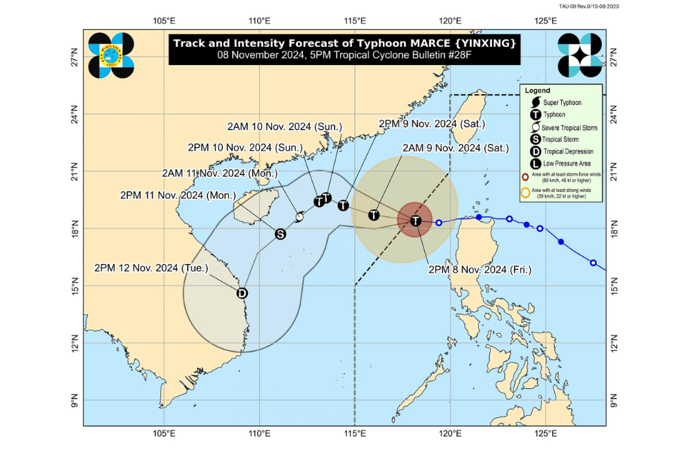
Typhoon #MarcePH (international name: YINXING) has exited the Philippine Area of Responsibility (PAR), according to the Philippine Atmospheric, Geophysical and Astronomical Services Administration (PAGASA).
As of 5 p.m., the center of #MarcePH was located at 18.4°N, 117.8°E, moving west-southwestward at 20 km/h over the West Philippine Sea.
The typhoon currently has maximum sustained winds of 150 km/h near its center, with gustiness reaching up to 185 km/h and a central pressure of 960 hPa. Its strong to typhoon-force winds extend up to 400 km from the center.
No Tropical Cyclone Wind Signal is currently in effect.
Other Hazards Affecting Land Areas:
Severe Winds: Strong to gale-force gusts from the northeasterly wind flow and the periphery of #MarcePH are expected to affect the following areas, especially in coastal and upland regions exposed to winds:
- Batanes
- Northern Cagayan, including Babuyan Islands
- Ilocos Region
Coastal Inundation: The threat of storm surge inundation over the country’s coastal areas has ceased, and a final Storm Surge Warning was issued at 2:00 p.m. today.
Hazards Affecting Coastal Waters
A Gale Warning remains in effect over the western seaboard of Northern Luzon. Mariners are advised to avoid navigating in these conditions.
24-Hour Sea Condition Outlook:
- Up to 4.5 m: Western seaboards of Ilocos Norte and Ilocos Sur.
- Sea travel is risky for all vessel types. Mariners should seek shelter until conditions improve.
- Up to 4.0 m: Seaboard of Zambales; western seaboards of Batanes and Babuyan Islands; remaining seaboard of Ilocos Region.
- Up to 3.5 m: Remaining seaboards of Batanes and Babuyan Islands; northern seaboard of mainland Cagayan.
- Up to 3.0 m: Remaining seaboard of mainland Cagayan, seaboard of Isabela.
- Up to 2.5 m: Seaboard of northern Aurora; western seaboards of Bataan, Lubang Islands, Calamian Islands, and mainland Palawan.
- Up to 2.0 m: Remaining seaboards of Aurora; northern and eastern seaboards of Polillo Islands, Catanduanes, Northern Samar; seaboards of Camarines Norte; northern seaboard of Camarines Sur; eastern seaboards of Albay, Sorsogon, Eastern Samar, Dinagat Islands, and Surigao del Sur.
Mariners operating motorbancas and similarly-sized vessels are advised to take precautions or avoid sea navigation, especially if lacking sufficient equipment.
Track and Intensity Outlook:
Typhoon #MarcePH is expected to continue moving westward to west-northwestward until tomorrow (November 9) over the West Philippine Sea. By Sunday (November 10), it may shift to a west-southwestward to southwestward path due to the surge of the northeasterly wind flow.
The typhoon is expected to re-intensify in the next 24 hours but will gradually weaken as it encounters less favorable conditions.


