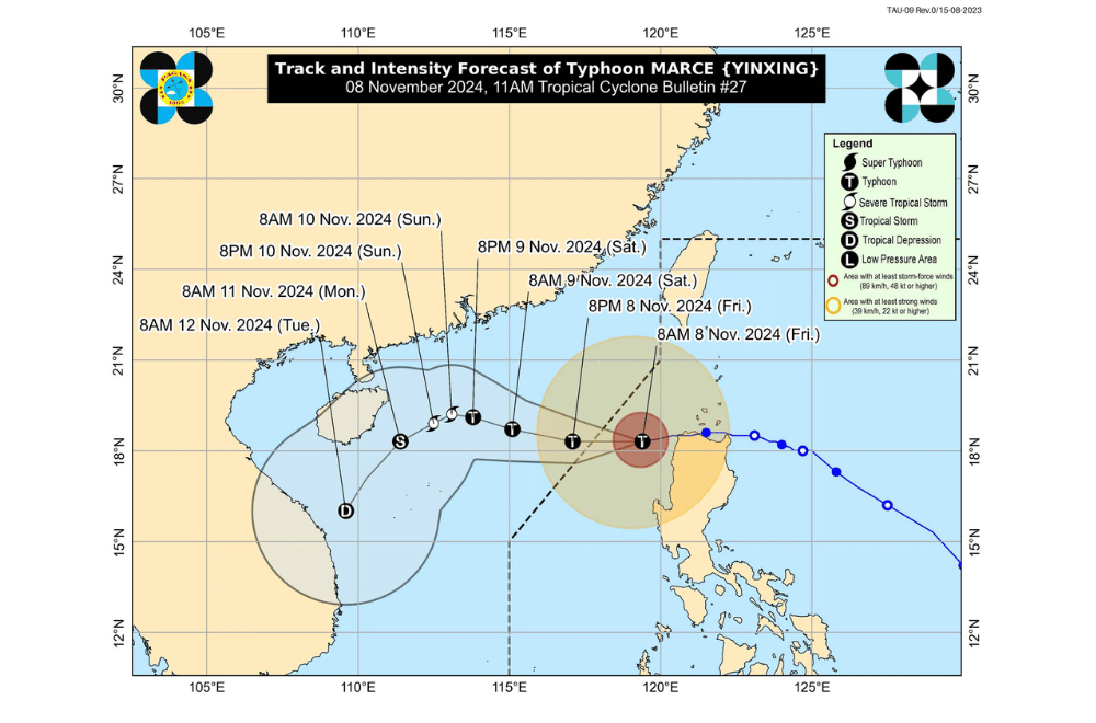
Typhoon #MarcePH has weakened slightly as it moves further away from Ilocos Region, according to the Philippine Atmospheric, Geophysical and Astronomical Services Administration (PAGASA).
As of 10:00 a.m. on November 8, 2024, the center of #MarcePH was located 165 km west of Laoag City, Ilocos Norte, or 165 km west of Batac, Ilocos Norte.
The storm is moving west-southwestward at a speed of 20 km/h.
The storm currently has maximum sustained winds of 140 km/h near its center, with gustiness reaching up to 170 km/h.
Tropical Cyclone Wind Signal No. 2 has been raised over:
- The northwestern portion of mainland Cagayan (Claveria, Santa Praxedes)
- The western portion of Apayao (Calanasan, Kabugao)
- Abra
- Ilocos Norte
- The northern portion of Ilocos Sur (Magsingal, San Esteban, Banayoyo, Burgos, City of Candon, Santiago, San Vicente, Santa Catalina, Lidlidda, Nagbukel, Sinait, San Ildefonso, Galimuyod, City of Vigan, San Emilio, Cabugao, Caoayan, San Juan, Santa, Bantay, Santo Domingo, Santa Cruz, Santa Maria, Narvacan, Salcedo, Santa Lucia)
Tropical Cyclone Wind Signal No. 1 has been raised over:
- Batanes
- Babuyan Islands
- The rest of mainland Cagayan
- The northern and western portions of Isabela (Santo Tomas, Alicia, San Mateo, Aurora, Santa Maria, Quezon, Ramon, Naguilian, Roxas, Luna, Delfin Albano, City of Cauayan, San Pablo, Ilagan City, Angadanan, Benito Soliven, City of Santiago, Tumauini, Cabagan, Reina Mercedes, San Manuel, Cabatuan, Quirino, Gamu, San Isidro, Mallig, Cordon, Maconacon, Burgos)
- The northern and western portions of Nueva Vizcaya (Diadi, Bagabag, Ambaguio, Villaverde, Bayombong, Solano, Quezon, Bambang, Kayapa, Santa Fe, Aritao)
- The northwestern portion of Quirino (Diffun, Saguday)
- The rest of Apayao
- Kalinga
- Mountain Province
- Ifugao
- Benguet
- The rest of Ilocos Sur
- La Union
- The northern and central portions of Pangasinan (Bani, Bolinao, Anda, City of Alaminos, Agno, Sual, Labrador, Burgos, Mabini, Lingayen, Binmaley, Dagupan City, Mangaldan, San Fabian, San Jacinto, Pozorrubio, Sison, San Manuel, San Nicolas, Tayug, Santa Maria, Binalonan, Asingan, Laoac, Manaoag, Mapandan, Santa Barbara, Calasiao, City of Urdaneta, Basista, Villasis, Malasiqui, Urbiztondo, Aguilar, Santo Tomas, San Carlos City, Bugallon, Infanta, Dasol)
Heavy Rainfall Outlook:
Typhoon Marce is less likely to bring heavy rainfall over the country in the next three days. A final Weather Advisory was issued earlier this morning.
Severe Winds:
- Minor to moderate impacts from gale-force winds are possible in areas under TCWS No. 2.
- Minimal to minor impacts from strong winds are possible in areas under TCWS No. 1.
The northeasterly wind flow, combined with the outer bands of Marce, will bring strong to gale-force gusts over:
- Today (8 November): Batanes, northern Cagayan including Babuyan Islands, and Ilocos Region.
Coastal Inundation:
A high risk of life-threatening storm surge exceeding 3.0 meters is expected in the next 48 hours over low-lying or exposed coastal areas in Babuyan Islands, Ilocos Norte, Ilocos Sur, and La Union.
Hazards Affecting Coastal Waters
A Gale Warning remains in effect for the northern and western seaboards of Northern Luzon. Sea travel is risky for all vessel types, especially for small and unprepared crafts.
24-Hour Sea Condition Outlook:
- Up to very rough seas (4.5 m): Seaboards of Ilocos Region; western seaboards of Batanes and Babuyan Islands
- Up to rough seas (4.0 m): Seaboard of Zambales
- Up to rough seas (3.5 m): Remaining seaboards of Batanes and Babuyan Islands; northern seaboard of mainland Cagayan
- Up to rough seas (3.0 m): Remaining seaboard of mainland Cagayan, seaboard of Isabela
- Up to moderate seas (2.5 m): Seaboard of northern Aurora; western seaboards of Bataan, Lubang Islands, Calamian Islands, and mainland Palawan
- Up to moderate seas (2.0 m): Remaining seaboards of Aurora; northern and eastern seaboards of Polillo Islands, Catanduanes, and Northern Samar; seaboards of Camarines Norte; northern seaboard of Camarines Sur; eastern seaboards of Albay, Sorsogon, Eastern Samar, Dinagat Islands, and Surigao del Sur
Mariners are advised to remain in port or seek safe harbor until sea conditions improve.
Track and Intensity Outlook
Typhoon Marce is forecast to continue moving generally westward and is expected to exit the Philippine Area of Responsibility (PAR) this afternoon or evening. The surge of the northeasterly wind flow will shift its movement southwestward by Sunday, November 10.
Marce is expected to gradually weaken over the coming days due to possible dry air intrusion but will remain classified as a typhoon throughout its time within the PAR.


