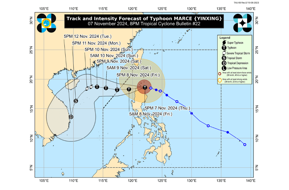
Typhoon #MarcePH is moving west-northwestward over the Babuyan Channel, and maintains life-threatening conditions across Northern Luzon, according to the Philippine Atmospheric, Geophysical and Astronomical Services Administration (PAGASA).
As of 8:00 p.m. on November 7, 2024, the eye of Typhoon Marce was positioned over the coastal waters of Aparri, Cagayan.
The typhoon is moving at a speed of 10 km/h in a west-northwestward direction.
Marce currently has maximum sustained winds of 175 km/h near its center, with gusts reaching up to 240 km/h.
Tropical Cyclone Wind Signal No. 4 has been raised over:
- The northern portion of Cagayan (Gonzaga, Santa Ana, Santa Teresita, Lal-Lo, Buguey, Aparri, Camalaniugan, Gattaran, Ballesteros, Allacapan, Abulug, Pamplona, Sanchez-Mira, Claveria, Santa Praxedes, Lasam), including Babuyan Islands
- The northern portion of Apayao (Santa Marcela, Luna, Flora, Calanasan, Pudtol)
- The northern portion of Ilocos Norte (Pagudpud, Bangui, Vintar, Dumalneg, Adams, Bacarra, Pasuquin, Burgos, Laoag City, Piddig, Carasi, San Nicolas, Sarrat)
Tropical Cyclone Wind Signal No. 3 has been raised over:
- Batanes
- The rest of Cagayan
- The rest of Apayao
- The rest of Ilocos Norte
- The northern portion of Abra (Tineg, Danglas, Lagayan, Lacub, San Juan, La Paz, Bangued)
- The northern portion of Ilocos Sur (Sinait, Cabugao, San Juan, Magsingal, Santo Domingo)
Tropical Cyclone Wind Signal No. 2 has been raised over:
- The northern and central portions of Isabela (San Pablo, Santa Maria, Divilacan, Tumauini, Maconacon, Cabagan, Santo Tomas, Quezon, Palanan, Ilagan City, Mallig, Delfin Albano, Quirino, San Mariano, Gamu, Roxas, Naguilian, Burgos, Reina Mercedes, Benito Soliven, Luna, Aurora, San Manuel, San Mateo, Alicia, Angadanan, City of Cauayan, Cabatuan)
- The rest of Abra
- Kalinga
- Mountain Province
- The northern portion of Ifugao (Alfonso Lista, Aguinaldo, Mayoyao, Banaue, Hungduan)
- The northern portion of Benguet (Bakun, Mankayan)
- The rest of Ilocos Sur
- The northern portion of La Union (Sudipen, Bangar, Balaoan, Luna, Santol)
Tropical Cyclone Wind Signal No. 1 has been raised over:
- The rest of La Union
- Pangasinan
- The rest of Ifugao
- The rest of Benguet
- The rest of Isabela
- Quirino
- Nueva Vizcaya
- The northern and central portions of Aurora (Dilasag, Casiguran, Dinalungan, Dipaculao, Maria Aurora, Baler)
- The northern portion of Nueva Ecija (Carranglan)
- The northern portion of Zambales (Santa Cruz, Candelaria)
Heavy Rainfall Outlook:
- Today (November 7):
- Intense to Torrential (>200 mm): Ilocos Norte, Apayao, and Cagayan
- Heavy to Intense (100-200 mm): Abra and Ilocos Sur
- Moderate to Heavy (50-100 mm): La Union, Kalinga, Mountain Province, Benguet, Ifugao, Batanes, and Isabela
Coastal Inundation:
There is a high risk of life-threatening storm surge, with peak surge heights exceeding 3.0 meters in the next 48 hours over low-lying coastal areas of Batanes, Cagayan (including Babuyan Islands), Isabela, Ilocos Norte, Ilocos Sur, and La Union.
Severe Winds:
Strong winds are expected in areas under TCWS No. 1 and 2, with possible stronger gusts in coastal and upland regions. Gale Warnings are also issued over Northern Luzon's seaboards and the western seaboard of Central Luzon, making sea travel risky.
Hazards Affecting Coastal Waters:
- 24-Hour Sea Condition Outlook: Extremely rough seas up to 12.0 m are anticipated in the seaboard of Babuyan Islands and Ilocos Norte. All mariners are advised to stay in port or seek shelter until conditions improve.
Track and Intensity Outlook:
Typhoon Marce is forecast to move westward, potentially making landfall along the coast of northwestern Cagayan. It is expected to exit the Philippine Area of Responsibility by November 8, with a chance of intensifying to a Super Typhoon after crossing northeastern Cagayan.


