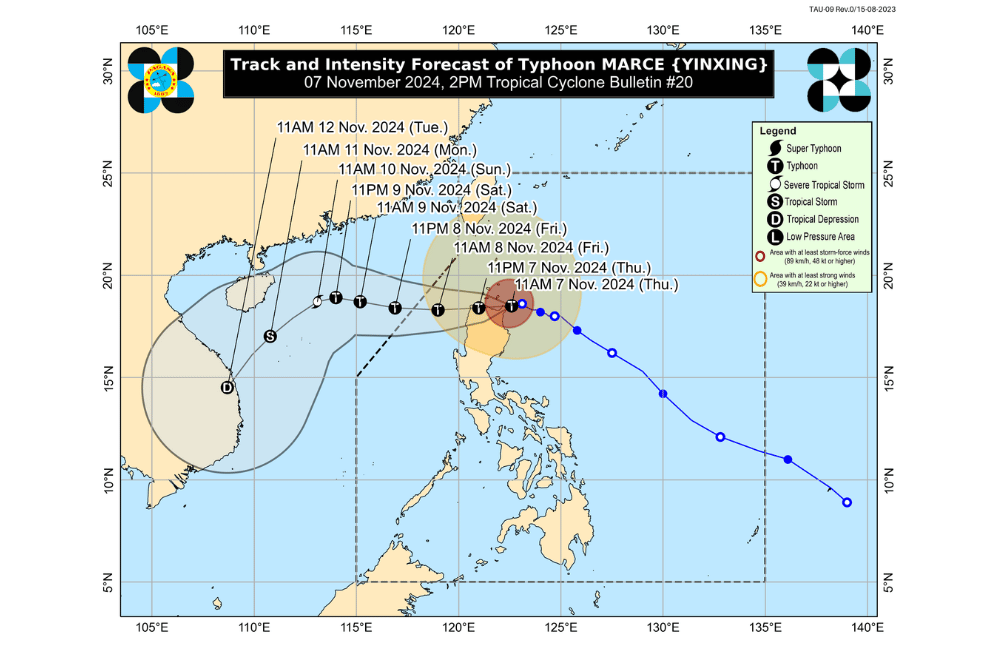
Typhoon #MarcePH continues to bring life-threatening conditions to northeastern Cagayan as it makes landfall over Santa Ana, Cagayan, according to the Philippine Atmospheric, Geophysical and Astronomical Services Administration (PAGASA).
As of 5:00 p.m., November 7, 2024, the center of Typhoon #MarcePH was located near Santa Ana, Cagayan (18.5 °N, 122.0 °E).
The typhoon is moving westward at a speed of 10 km/h.
The storm has maximum sustained winds of 175 km/h near its center, with gustiness reaching up to 240 km/h.
Tropical Cyclone Wind Signal No. 4 has been raised over:
- The northern portion of Cagayan (Gonzaga, Santa Ana, Santa Teresita, Lal-Lo, Buguey, Aparri, Camalaniugan, Gattaran, Ballesteros, Allacapan, Abulug, Pamplona, Sanchez-Mira, Claveria, Santa Praxedes, Lasam)
- Babuyan Islands
- The northern portion of Apayao (Santa Marcela, Luna, Flora, Calanasan, Pudtol)
- The northern portion of Ilocos Norte (Pagudpud, Bangui, Vintar, Dumalneg, Adams, Bacarra, Pasuquin, Burgos)
Tropical Cyclone Wind Signal No. 3 has been raised over:
- Batanes
- The rest of Cagayan
- The rest of Apayao
- The rest of Ilocos Norte
- The northern portion of Abra (Tineg, Danglas, Lagayan, Lacub, San Juan, La Paz, Bangued)
- The northern portion of Ilocos Sur (Sinait, Cabugao, San Juan, Magsingal, Santo Domingo)
Tropical Cyclone Wind Signal No. 2 has been raised over:
- The northern and central portions of Isabela (San Pablo, Santa Maria, Divilacan, Tumauini, Maconacon, Cabagan, Santo Tomas, Quezon, Palanan, Ilagan City, Mallig, Delfin Albano, Quirino, San Mariano, Gamu, Roxas, Naguilian, Burgos, Reina Mercedes, Benito Soliven, Luna, Aurora, San Manuel, San Mateo, Alicia, Angadanan, City of Cauayan, Cabatuan)
- The rest of Abra
- Kalinga
- Mountain Province
- The northern portion of Ifugao (Alfonso Lista, Aguinaldo, Mayoyao, Banaue, Hungduan)
- The northern portion of Benguet (Bakun, Mankayan)
- The rest of Ilocos Sur
- The northern portion of La Union (Sudipen, Bangar, Balaoan, Luna, Santol)
Tropical Cyclone Wind Signal No. 1 has been raised over:
- The rest of La Union
- Pangasinan
- The rest of Ifugao
- The rest of Benguet
- The rest of Isabela
- Quirino
- Nueva Vizcaya
- The northern and central portions of Aurora (Dilasag, Casiguran, Dinalungan, Dipaculao, Maria Aurora, Baler)
- The northern portion of Nueva Ecija (Carranglan)
- The northern portion of Zambales (Santa Cruz, Candelaria)
Heavy Rainfall Outlook:
PAGASA forecasted rainfall in the following areas:
- Intense to Torrential: Cagayan, Apayao, Ilocos Norte, Abra, and Ilocos Sur (over 200 mm)
- Heavy to Intense: Batanes and Isabela (100–200 mm)
- Moderate to Heavy: La Union, Kalinga, Mountain Province, Benguet, and Ifugao (50–100 mm)
The heavy rainfall could lead to flooding and landslides, particularly in elevated or mountainous regions. Residents are advised to take precautions.
Coastal Inundation:
There is a high risk of life-threatening storm surge with peak surge heights exceeding 3.0 meters in the next 48 hours over the low-lying or exposed coastal localities of:
- Batanes
- Cagayan, including Babuyan Islands
- Isabela
- Ilocos Norte
- Ilocos Sur
- La Union
Hazards Affecting Coastal Waters:
A Gale Warning is in effect for the seaboards of Northern Luzon and the western seaboard of Central Luzon. Sea travel is risky for all types or tonnage of vessels, and mariners are advised to remain in port or seek shelter.
24-Hour Sea Condition Outlook:
- Up to 12.0 m: The seaboard of Babuyan Islands and Ilocos Norte; the northern seaboards of mainland Cagayan
- Up to 8.0 m: The remaining seaboard of Cagayan
- Up to 7.0 m: The seaboards of Batanes and Ilocos Sur
- Up to 5.0 m: The remaining seaboard of Ilocos Region
- Up to 4.5 m: The seaboards of northern Zambales and Isabela
Sea travel is risky, especially for small vessels. Mariners are advised to avoid navigation under these conditions.
Track and Intensity Outlook:
Typhoon #MarcePH is expected to continue moving generally westward and may make another landfall along the coast of northwestern mainland Cagayan tonight. The typhoon is forecast to emerge over the West Philippine Sea early on November 8, 2024.
The storm is expected to continue weakening as it moves across northern Luzon, though it will remain a typhoon throughout its passage within the Philippine Area of Responsibility. The surge of the northeasterly wind flow will likely lead to a continuous weakening of the storm during the weekend.
PAGASA advises the public to stay updated on further advisories and take the necessary precautions as Typhoon #MarcePH progresses.


