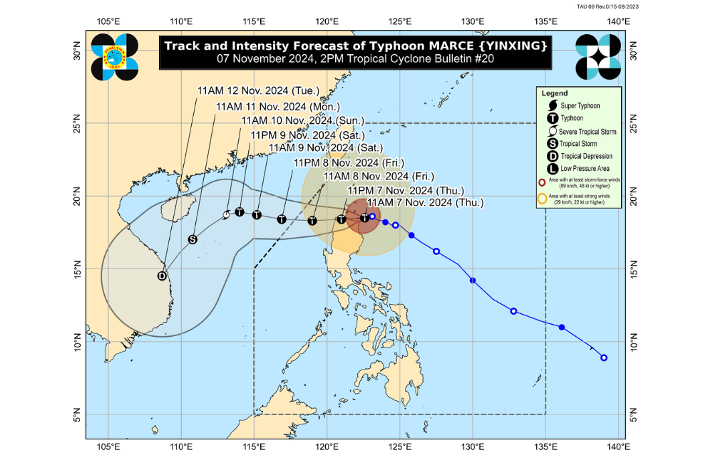
Typhoon #MarcePH has further intensified and is moving dangerously close to northeastern Cagayan, according to the Philippine Atmospheric, Geophysical, and Astronomical Services Administration (PAGASA).
As of 2:00 p.m. on November 7, 2024, the center of #MarcePH was located over the coastal waters of Santa Ana, Cagayan.
The typhoon is moving west-northwestward at a speed of 10 km/h.
#MarcePH currently has maximum sustained winds of 175 km/h near its center, with gustiness reaching up to 240 km/h.
Tropical Cyclone Wind Signal No. 4 has been raised over:
- The northern portion of Cagayan (Gonzaga, Santa Ana, Santa Teresita, Lal-Lo, Buguey, Aparri, Camalaniugan, Gattaran, Ballesteros, Allacapan, Abulug, Pamplona, Sanchez-Mira, Claveria, Santa Praxedes, Lasam), including Babuyan Islands
- The northern portion of Apayao (Santa Marcela, Luna, Flora, Calanasan, Pudtol)
- The northern portion of Ilocos Norte (Pagudpud, Bangui, Vintar, Dumalneg, Adams, Bacarra, Pasuquin, Burgos)
Tropical Cyclone Wind Signal No. 3 has been raised over:
- Batanes
- The rest of Cagayan
- The rest of Apayao
- The rest of Ilocos Norte
- The northern portion of Abra (Tineg, Danglas, Lagayan, Lacub, San Juan, La Paz, Bangued)
- The northern portion of Ilocos Sur (Sinait, Cabugao, San Juan, Magsingal, Santo Domingo)
Tropical Cyclone Wind Signal No. 2 has been raised over:
- The northern and central portions of Isabela (San Pablo, Santa Maria, Divilacan, Tumauini, Maconacon, Cabagan, Santo Tomas, Quezon, Palanan, Ilagan City, Mallig, Delfin Albano, Quirino, San Mariano, Gamu, Roxas, Naguilian, Burgos, Reina Mercedes, Benito Soliven, Luna, Aurora, San Manuel, San Mateo, Alicia, Angadanan, City of Cauayan, Cabatuan)
- The rest of Abra
- Kalinga
- Mountain Province
- The northern portion of Ifugao (Alfonso Lista, Aguinaldo, Mayoyao, Banaue, Hungduan)
- The northern portion of Benguet (Bakun, Mankayan)
- The rest of Ilocos Sur
- The northern portion of La Union (Sudipen, Bangar, Balaoan, Luna, Santol)
Tropical Cyclone Wind Signal No. 1 has been raised over:
- The rest of La Union
- Pangasinan
- The rest of Ifugao
- The rest of Benguet
- The rest of Isabela
- Quirino
- Nueva Vizcaya
- The northern and central portions of Aurora (Dilasag, Casiguran, Dinalungan, Dipaculao, Maria Aurora, Baler)
- The northern portion of Nueva Ecija (Carranglan)
- The northern portion of Zambales (Santa Cruz, Candelaria)
Heavy Rainfall Outlook:
Today (November 7):
- Intense to Torrential (>200 mm): Cagayan, Ilocos Norte, Apayao
- Heavy to Intense (100–200 mm): Batanes, Ilocos Sur, Isabela, Abra
- Moderate to Heavy (50–100 mm): La Union, Kalinga, Mountain Province, Benguet, Ifugao
Coastal Inundation:
A high risk of life-threatening storm surge is expected, with peak surge heights exceeding 3.0 meters within the next 48 hours along low-lying or exposed coastal areas of Batanes, Cagayan (including Babuyan Islands), Isabela, Ilocos Norte, Ilocos Sur, and La Union.
Hazards Affecting Coastal Waters:
Gale Warnings are in effect for the seaboards of Northern and Central Luzon. Mariners are advised against sea travel in these regions.
24-Hour Sea Condition Outlook:
- Up to 12.0 m: The seaboard of Babuyan Islands and Ilocos Norte; the northern seaboard of mainland Cagayan
- Up to 8.0 m: The remaining seaboard of Cagayan
- Up to 7.0 m: The seaboards of Batanes and northern Ilocos Sur
- Up to 6.0 m: The remaining seaboard of Ilocos Sur; the seaboard of Isabela
- Up to 5.0 m: The remaining seaboard of the Ilocos Region
- Up to 4.5 m: The seaboards of northern Zambales and northern Aurora
- Up to 4.0 m: The seaboard of Kalayaan Islands
- Up to 3.5 m: The northern and eastern seaboards of Polillo Islands; the seaboards of Camarines Norte; the northern seaboards of Catanduanes and Camarines Sur; the remaining seaboard of Zambales
- Up to 3.0 m: The eastern seaboard of Catanduanes; the seaboard of northern Quezon; the remaining seaboard of Aurora; the western seaboards of Bataan, Lubang Islands, mainland Palawan, and Calamian Islands
- Up to 2.5 m: The northern and eastern seaboards of Northern Samar; the eastern seaboards of Albay, Sorsogon, and Eastern Samar
- Up to 2.0 m: The western seaboards of Occidental Mindoro; the eastern seaboard of Camarines Sur, Dinagat Islands, and Surigao del Sur
Mariners of small seacrafts are advised to avoid sea travel under these conditions, especially if operating ill-equipped vessels.
Track and Intensity Outlook:
Typhoon #MarcePH is expected to make landfall in Santa Ana, Cagayan, between 2:00 p.m. and 4:00 p.m. today. It will move westward, briefly emerging over Aparri Bay and making another landfall along the northwestern Cagayan coast. #MarcePH is likely to exit the Philippine Area of Responsibility by tomorrow afternoon or evening.
PAGASA advises the public to stay updated on further advisories and take necessary precautions as #MarcePH continues its track westward.


