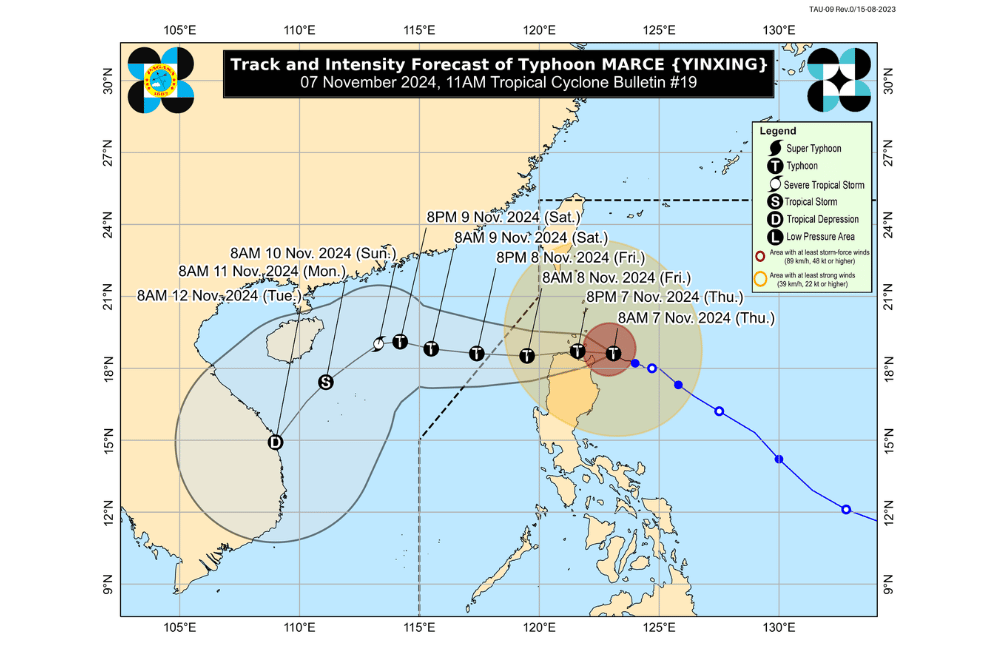
Typhoon #MarcePH has intensified further and is moving dangerously close to northeastern Cagayan, according to the Philippine Atmospheric, Geophysical, and Astronomical Services Administration (PAGASA).
As of 11:00 a.m. on November 7, 2024, the center of #MarcePH was located approximately 115 km east of Aparri, Cagayan.
The typhoon is moving west-northwestward at a speed of 10 km/h.
It currently has maximum sustained winds of 175 km/h near its center, with gusts reaching up to 215 km/h.
Tropical Cyclone Wind Signal No. 4 has been raised over:
- The northern portion of Cagayan (Gonzaga, Santa Ana, Santa Teresita, Lal-Lo, Buguey, Aparri, Camalaniugan, Gattaran, Ballesteros, Allacapan, Abulug, Pamplona, Sanchez-Mira, Claveria, Santa Praxedes, Lasam) including Babuyan Islands
- The northern portion of Apayao (Santa Marcela, Luna, Flora, Calanasan, Pudtol)
- The northern portion of Ilocos Norte (Pagudpud, Bangui, Vintar, Dumalneg, Adams, Bacarra, Pasuquin, Burgos)
Tropical Cyclone Wind Signal No. 3 has been raised over:
- Batanes
- The rest of Cagayan
- The rest of Apayao
- The rest of Ilocos Norte
- The northern portion of Abra (Tineg, Danglas, Lagayan, Lacub, San Juan, La Paz, Bangued)
- The northern portion of Ilocos Sur (Sinait, Cabugao, San Juan, Magsingal, Santo Domingo)
Tropical Cyclone Wind Signal No. 2 has been raised over:
- The northern and central portions of Isabela (San Pablo, Santa Maria, Divilacan, Tumauini, Maconacon, Cabagan, Santo Tomas, Quezon, Palanan, Ilagan City, Mallig, Delfin Albano, Quirino, San Mariano, Gamu, Roxas, Naguilian, Burgos, Reina Mercedes, Benito Soliven, Luna, Aurora, San Manuel, San Mateo, Alicia, Angadanan, City of Cauayan, Cabatuan)
- The rest of Abra
- Kalinga
- Mountain Province
- The northern portion of Ifugao (Alfonso Lista, Aguinaldo, Mayoyao, Banaue, Hungduan)
- The northern portion of Benguet (Bakun, Mankayan)
- The rest of Ilocos Sur
- The northern portion of La Union (Sudipen, Bangar, Balaoan, Luna, Santol)
Tropical Cyclone Wind Signal No. 1 has been raised over:
- The rest of La Union
- Pangasinan
- The rest of Ifugao
- The rest of Benguet
- The rest of Isabela
- Quirino
- Nueva Vizcaya
- The northern and central portions of Aurora (Dilasag, Casiguran, Dinalungan, Dipaculao, Maria Aurora, Baler)
- The northern portion of Nueva Ecija (Carranglan)
- The northern portion of Zambales (Santa Cruz, Candelaria)
Heavy Rainfall Outlook:
PAGASA has warned of heavy rainfall from "Marce" and the enhanced Northeast Monsoon. The rainfall forecast is as follows:
- Intense to Torrential (>200 mm): Cagayan and Apayao
- Heavy to Intense (100 – 200 mm): Batanes, Ilocos Norte, Ilocos Sur, Isabela, and Abra
- Moderate to Heavy (50 – 100 mm): La Union, Kalinga, Mountain Province, Benguet, and Ifugao
Flooding and landslides may occur, especially in mountainous regions. Residents in affected areas are advised to take necessary precautions.
Coastal Inundation:
There is a high risk of life-threatening storm surge, with peak surge heights exceeding 3.0 meters expected within the next 48 hours over the low-lying or exposed coastal areas of Batanes, Cagayan (including Babuyan Islands), Isabela, Ilocos Norte, Ilocos Sur, and La Union. Storm Surge Warning No. 8, issued at 8:00 a.m., provides additional details.
Hazards Affecting Coastal Waters:
A Gale Warning is in effect, with sea conditions ranging from rough to very high, especially over the following areas:
- Up to 12.0 m: Babuyan Islands, Ilocos Norte, and northern seaboards of mainland Cagayan
- Up to 8.0 m: Remaining seaboard of Cagayan
- Up to 7.0 m: Seaboards of Batanes and northern Ilocos Sur
- Up to 6.0 m: Remaining seaboard of Ilocos Sur and seaboard of Isabela
- Up to 5.0 m: Remaining seaboards of the Ilocos Region
- Up to 4.5 m: Seaboards of northern Zambales and northern Aurora
Sea travel is highly risky for all vessels. Mariners are advised to remain in port or seek shelter until conditions improve.
Track and Intensity Outlook:
#MarcePH is projected to make landfall or traverse the Babuyan Islands and/or northern Cagayan, Ilocos Norte, and Apayao by this afternoon through early tomorrow (November 8) morning. Despite possible landfall or close approach, typhoon-force winds, storm surge, and torrential rain are expected in Babuyan Islands and northern Cagayan, Ilocos Norte, and Apayao.
The typhoon is likely to maintain its strength as it moves westward and may exit the Philippine Area of Responsibility by tomorrow evening, followed by gradual weakening during the weekend due to interaction with Luzon’s terrain and the prevailing northeasterly wind flow.
PAGASA advises the public to stay updated on further advisories and take necessary precautions as #MarcePH progresses.


