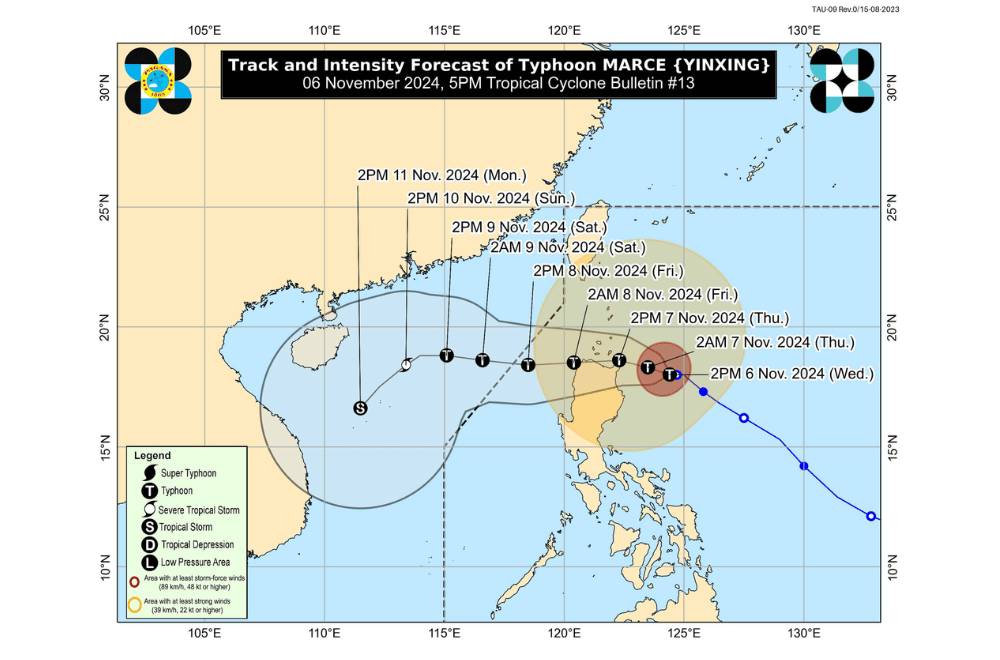
Typhoon #MarcePH has intensified and is now nearly stationary over the waters east of Northern Cagayan, according to the Philippine Atmospheric, Geophysical and Astronomical Services Administration (PAGASA).
As of 4:00 p.m. on November 6, 2024, the center of Typhoon #MarcePH was located 295 km east of Aparri, Cagayan, at coordinates 18.0°N, 124.4°E.
The storm is moving westward slowly.
Typhoon #MarcePH currently has maximum sustained winds of 150 km/h near its center, with gustiness reaching up to 185 km/h. Its central pressure is at 970 hPa.
Tropical Cyclone Wind Signal No. 3 has been raised over:
- The northeastern portion of mainland Cagayan (Santa Ana, Gonzaga)
Tropical Cyclone Wind Signal No. 2 has been raised over:
- Batanes
- The rest of Cagayan, including Babuyan Islands
- The northern portion of Isabela (Maconacon, San Pablo, Santa Maria, Divilacan)
- Apayao
- The northern portion of Kalinga (Rizal, Pinukpuk, Balbalan)
- The northern portion of Abra (Langiden, Bangued, Danglas, Tayum, La Paz, Dolores, Lagayan, San Juan, Lagangilang, Tineg, Lacub, Licuan-Baay, Malibcong)
- Ilocos Norte
- The northern portion of Ilocos Sur (Sinait, Cabugao, San Juan, Magsingal, Santo Domingo, Bantay, San Ildefonso, San Vicente, Santa Catalina)
Tropical Cyclone Wind Signal No. 1 has been raised over:
- The rest of Ilocos Sur
- La Union
- The northwestern portion of Pangasinan (Bani, Bolinao, Anda, City of Alaminos, Agno, Sual)
- The rest of Abra
- The rest of Kalinga
- Mountain Province
- Ifugao
- Benguet
- The rest of Isabela
- Quirino
- Nueva Vizcaya
- The northern portion of Aurora (Dilasag, Casiguran, Dinalungan, Dipaculao, Maria Aurora, Baler)
Rainfall Forecast
Typhoon Marce is anticipated to bring heavy to torrential rains across Northern Luzon:
- Today, November 6: Heavy to intense rains over Cagayan, Apayao, and Ilocos Norte, with moderate to heavy rains expected in Batanes, Abra, Isabela, Aurora, and Ilocos Sur.
- Tomorrow, November 7: Intense to torrential rains in Cagayan, Apayao, and Ilocos Norte, with heavy to intense rains forecasted for Batanes, Abra, and Ilocos Sur. Other areas, including Kalinga and Mountain Province, will experience moderate to heavy rains.
- Friday, November 8: Continued intense rainfall over Apayao and Ilocos Norte, and heavy rains in Ilocos Sur, Abra, and parts of Northern Luzon.
Coastal Warnings
The typhoon will bring hazardous sea conditions across Northern Luzon:
- Coastal waters: Very rough seas are expected along the seaboards of Babuyan Islands, mainland Cagayan, Ilocos Norte, and Isabela, with waves reaching up to 12.0 meters in some areas.
- Storm surge risk: Areas including Batanes, Cagayan, Isabela, Ilocos Norte, and Ilocos Sur are at high risk, with potential storm surges above 3.0 meters over low-lying coastal zones.
PAGASA has advised all mariners and small seacraft operators to avoid sea travel in these conditions, with warnings extending over nearby waters of Northern Samar, Eastern Samar, and Bicol.
Track and Intensity Outlook
Typhoon Marce is expected to maintain its current intensity as it begins a west-northwestward motion. On its projected path, Marce could make landfall or closely approach the Babuyan Islands and northern Cagayan from November 7 to early November 8, then move out of the Philippine Area of Responsibility by Friday evening. Gradual weakening is expected over the weekend as Marce interacts with terrain and cooler winds from the northeast.


