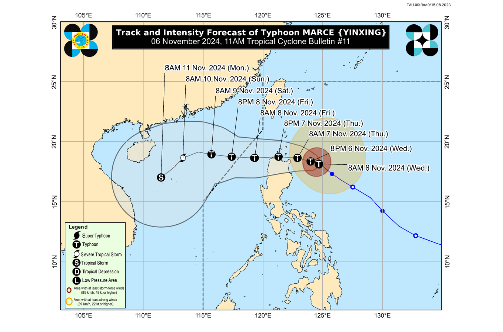
Typhoon #MarcePH has intensified and now poses a threat to the Babuyan Islands and Northern Luzon, the Philippine Atmospheric, Geophysical and Astronomical Services Administration (PAGASA) announced.
As of 11:00 a.m. on November 6, 2024, the center of Typhoon "Marce" was located 315 km East of Aparri, Cagayan.
The storm is moving westward at 10 km/h
"Marce" currently has maximum sustained winds of 150 km/h near its center, with gustiness reaching up to 185 km/h.
Tropical Cyclone Wind Signal No. 3 raised over:
- The northeastern portion of mainland Cagayan (Santa Ana)
Tropical Cyclone Wind Signal No. 2 raised over:
- Batanes
- Babuyan Islands
- Northern portion of mainland Cagayan (Gonzaga, Lal-Lo, Santa Teresita, Buguey, Gattaran, Baggao, Lasam, Abulug, Camalaniugan, Pamplona, Claveria, Aparri, Ballesteros, Allacapan, Sanchez-Mira, Santa Praxedes, Rizal, Santo Niño, Alcala, Amulung)
- Northern portion of Apayao (Calanasan, Luna, Pudtol, Santa Marcela, Flora, Kabugao)
Tropical Cyclone Wind Signal No. 1 raised over:
- Ilocos Norte
- Ilocos Sur
- Abra
- The rest of Apayao
- Kalinga
- Mountain Province
- Ifugao
- Northern portion of Benguet (Mankayan, Buguias, Kabayan, Bakun, Kibungan, Bokod, Atok)
- The rest of mainland Cagayan
- Isabela
- Quirino
- Nueva Vizcaya
- Northern portion of Aurora (Dilasag, Casiguran, Dinalungan, Dipaculao, Maria Aurora, Baler)
Heavy Rainfall Outlook:.
- Today (November 6): Heavy to intense rainfall (100–200 mm) in Cagayan; moderate to heavy rainfall (50–100 mm) in Batanes, Isabela, and Aurora.
- Tomorrow (November 7): Intense to torrential rainfall (>200 mm) in Cagayan and Apayao; heavy to intense rainfall in Ilocos Norte, Batanes, and Abra.
- Friday (November 8): Continued intense rainfall in Cagayan, Apayao, and Ilocos Norte, with heavy to intense conditions in Ilocos Sur, Abra, and Batanes.
Severe Winds:
Significant impacts from gale-force winds are expected in areas under TCWS No. 3. Moderate to significant impacts are expected in areas under TCWS No. 2, and minor impacts in TCWS No. 1 areas. The enhanced northeasterly wind flow will bring gusty conditions to other areas, including the Ilocos Region, Zambales, and Polillo Islands.
Coastal Inundation:
A storm surge warning indicates a high risk of life-threatening storm surges reaching 2.0 to 3.0 meters above normal tide levels over low-lying coastal areas of Batanes, Cagayan including Babuyan Islands, Isabela, Ilocos Norte, and Ilocos Sur.
Hazards Affecting Coastal Waters:
A Gale Warning has been issued for the northern seaboards, with sea travel considered extremely dangerous for all types of vessels in affected areas. Mariners are advised to stay in port until conditions improve.
24-Hour Sea Condition Outlook
Very rough to high seas are expected in:
- Up to 12.0 m: Eastern seaboard of Babuyan Islands, northeastern seaboard of mainland Cagayan
- Up to 8.0 m: Seaboard of Batanes, Babuyan Islands, northern seaboard of mainland Cagayan
- Up to 7.0 m: Remaining seaboard of mainland Cagayan, northern seaboard of Ilocos Norte
- Up to 6.0 m: Remaining seaboard of Ilocos Norte, seaboard of Isabela
- Up to 5.5 m: Seaboard of Ilocos Sur
- Up to 4.5 m: Remaining seaboard of Ilocos Region, northern seaboard of Aurora
Moderate to rough seas are also expected, with smaller vessels advised to take precautionary measures.
Track and Intensity Outlook:
Typhoon "Marce" is expected to move westward over the Babuyan Channel and northern West Philippine Sea. The storm could make landfall in the Babuyan Islands or northern parts of Cagayan, Ilocos Norte, and Apayao as early as tomorrow afternoon. It is likely to exit the Philippine Area of Responsibility by Friday evening.


