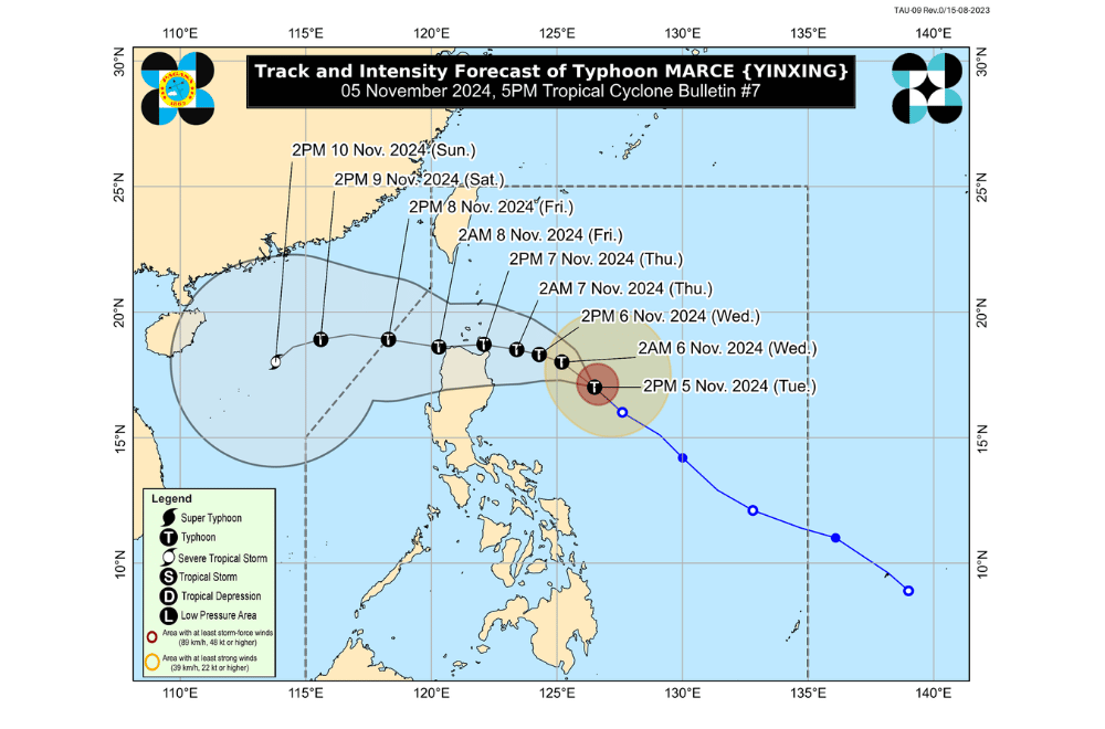
Typhoon #MarcePH has slightly intensified as it moves northwestward over the Philippine Sea east of Isabela, according to the Philippine Atmospheric, Geophysical, and Astronomical Services Administration (PAGASA).
As of 5:00 p.m. on November 5, 2024, the center of #MarcePH was located approximately 480 km east of Echague, Isabela.
The typhoon is moving northwestward at a speed of 25 km/h.
#MarcePH currently has maximum sustained winds of 130 km/h near its center, with gustiness reaching up to 160 km/h.
Tropical Cyclone Wind Signal No. 1 has been raised over:
- Batanes
- Cagayan, including Babuyan Islands
- Ilocos Norte
- Ilocos Sur
- Apayao
- Abra
- Kalinga
- Mountain Province
- Ifugao
- The northern portion of Benguet (Mankayan, Buguias, Kabayan, Bakun, Kibungan, Atok, Bokod)
- Isabela
- Nueva Vizcaya
- Quirino
- The northern portion of Aurora (Dilasag, Casiguran, Dinalungan, Dipaculao, Baler, Maria Aurora)
Heavy Rainfall Outlook:
- Today afternoon until tomorrow afternoon (November 6):
- Cagayan – Moderate to heavy rainfall (50–100 mm)
- Tomorrow afternoon until Thursday afternoon (November 7):
- Batanes, Cagayan, and Apayao – Moderate to heavy rainfall (50–100 mm)
- Thursday afternoon until Friday afternoon (November 8):
- Cagayan – Intense to torrential rainfall (>200 mm)
- Apayao, Ilocos Norte, and Batanes – Heavy to intense rainfall (100–200 mm)
- Isabela, Abra, Ilocos Sur, Kalinga, and Mountain Province – Moderate to heavy rainfall (50–100 mm)
Residents in these areas are advised to take precautionary measures due to potential flooding and landslides, especially in mountainous regions.
Severe Winds:
Areas under Wind Signal No. 1 may experience minimal to minor impacts from strong winds. The highest wind signal expected during #MarcePH is Wind Signal No. 4. Strong to gale-force gusts due to the northeasterly wind flow are also expected in the following areas:
- Today (November 5): Ilocos Sur, Aurora, Quezon, and Camarines Norte.
- Tomorrow (November 6): Ilocos Region, Quezon, Camarines Norte, Camarines Sur, and Catanduanes.
Hazards Affecting Coastal Waters:
A Gale Warning is in effect over the northern and eastern seaboards of Northern Luzon. Sea travel is risky, and all mariners are advised to remain in port or seek shelter until sea conditions improve.
24-Hour Sea Condition Outlook:
- Up to very rough or high seas:
- Up to 7.0 m: Seaboards of Batanes, Babuyan Islands, and northeastern mainland Cagayan
- Up to 6.0 m: Remaining seaboard of mainland Cagayan; northern seaboard of Ilocos Norte
- Up to 5.0 m: Western seaboard of Ilocos Norte; seaboards of Ilocos Sur and Isabela
- Up to 4.5 m: Remaining seaboard of Ilocos Region; seaboard of northern Aurora
- Up to rough seas:
- Up to 3.5 m: Remaining seaboard of Aurora; northern and eastern seaboard of Polillo Islands
- Up to 3.0 m: Seaboard of Camarines Norte; northern seaboards of Camarines Sur; northern and eastern seaboards of Catanduanes; western seaboard of Zambales
- Up to moderate seas:
- Up to 2.5 m: Eastern seaboards of Albay, Sorsogon, and Eastern Samar; northern and eastern seaboard of Northern Samar
- Up to 2.0 m: Western seaboards of Bataan, Lubang Islands, Kalayaan Islands, Calamian Islands, and northern mainland Palawan; eastern seaboard of Camarines Sur, Dinagat Islands, Surigao del Sur, and Davao Oriental
Track and Intensity Outlook:
#MarcePH is forecast to continue moving northwestward until tomorrow (November 6) before slowing down and shifting westward over the Philippine Sea east of Extreme Northern Luzon. It is expected to make landfall or pass close to Babuyan Islands or the northern portion of mainland Cagayan on Thursday afternoon or evening (November 7). The typhoon may intensify further and reach its peak strength before landfall.
PAGASA advises the public to stay updated on further advisories and take necessary precautions as #MarcePH progresses.


