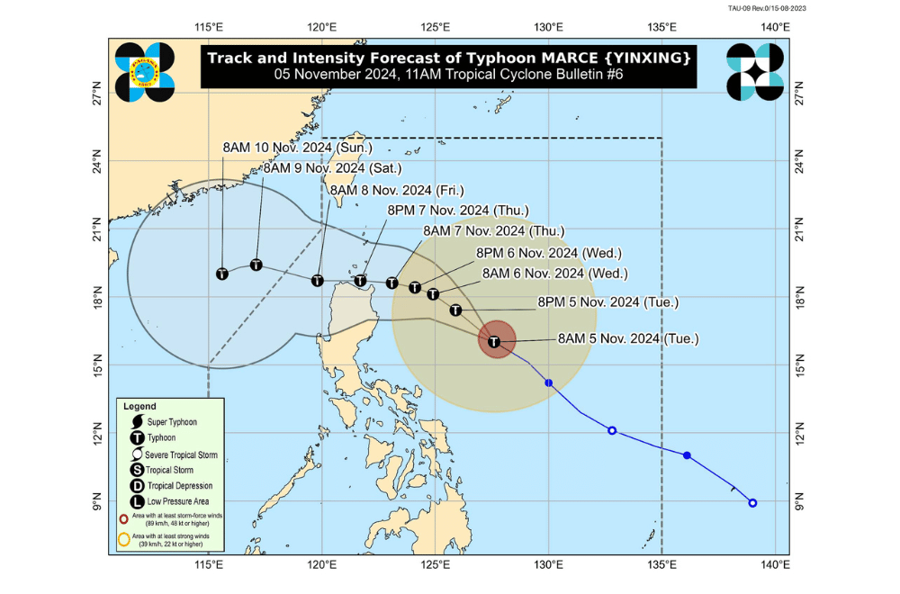
#MarcePH has strengthened into a typhoon while moving west northwestward over the Philippine Sea, according to the Philippine Atmospheric, Geophysical and Astronomical Services Administration (PAGASA).
As of 10:00 a.m. on November 5, 2024, the center of #MarcePH was located approximately 590 km east of Baler, Aurora.
The typhoon is moving at a speed of 30 km/h in a west northwestward direction.
The storm currently has maximum sustained winds of 120 km/h near its center, with gustiness reaching up to 150 km/h.
Tropical Cyclone Wind Signal No. 1 has been raised over:
- Batanes
- Cagayan, including Babuyan Islands
- Isabela
- Ilocos Norte
- Apayao
- Abra
- Kalinga
- Mountain Province
- Ifugao
- The northern portion of Nueva Vizcaya (Diadi, Bagabag, Ambaguio, Villaverde, Bayombong, Solano, Quezon, Kasibu)
- The northern portion of Quirino (Diffun, Saguday, Cabarroguis, Aglipay, Maddela)
- The northern portion of Aurora (Dilasag, Casiguran, Dinalungan)
Severe Winds:
Strong winds are expected in areas under TCWS No. 1, with slightly stronger winds in coastal and upland areas. The highest Wind Signal during Marce’s occurrence may reach up to Signal No. 4.
The northeasterly wind flow will also bring strong to gale-force gusts over the following areas:
- Today (November 5): Ilocos Sur, Aurora, Quezon, and Camarines Norte
- Tomorrow (November 6): Ilocos Region, Quezon, Camarines Norte, Camarines Sur, and Catanduanes
Hazards Affecting Coastal Waters:
A Gale Warning is in effect for the northern and eastern seaboards of Northern Luzon. Sea travel is risky for all vessel types due to hazardous conditions.
24-Hour Sea Condition Outlook:
- Up to high seas (up to 6.0 m): Batanes, Babuyan Islands, and the eastern seaboard of mainland Cagayan
- Up to very rough seas (up to 5.5 m): Seaboard of Isabela
- Up to 5.0 m: Northern seaboards of Ilocos Norte and mainland Cagayan
- Up to 4.5 m: Western seaboard of Ilocos Norte
- Up to rough seas:
- 4.0 m: Seaboards of northern Aurora and Ilocos Sur
- 3.5 m: Remaining seaboard of Ilocos Region, northern and eastern seaboards of Polillo Islands, seaboard of Camarines Norte, northern seaboard of Catanduanes, and Camarines Sur
- 3.0 m: Western seaboard of Zambales, eastern seaboard of Catanduanes
- Mariners of small seacrafts are advised against sea travel, especially in less-equipped or smaller vessels.
- Up to moderate seas:
- 2.5 m: Eastern seaboards of Albay, Sorsogon, and northern/eastern seaboards of Northern Samar
- 2.0 m: Eastern seaboards of Camarines Sur, Eastern Samar, Dinagat Islands, Surigao del Sur, Davao Oriental, Davao del Sur, and western seaboards of Bataan, Lubang Islands, Calamian Islands, Kalayaan Islands, and northern mainland Palawan
- Mariners are advised to exercise caution in these areas, avoiding navigation where possible.
PAGASA advises the public to stay updated on further advisories and take necessary precautions as #MarcePH progresses.


