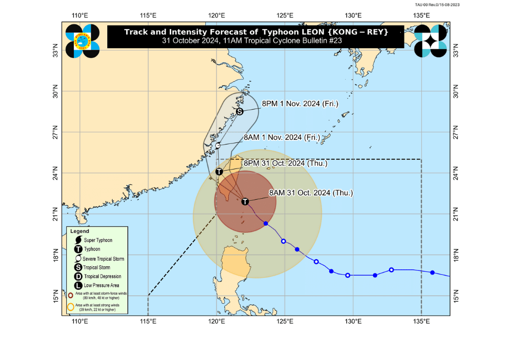
Typhoon #LeonPH has weakened as it passes close to the Orchid Islands in southern Taiwan, according to the Philippine Atmospheric, Geophysical and Astronomical Services Administration (PAGASA).
As of 11:00 a.m. on October 31, 2024, the center of #LeonPH was located approximately 155 km north of Itbayat, Batanes.
The typhoon is moving at a speed of 25 km/h in a northwestward direction.
#LeonPH currently has maximum sustained winds of 175 km/h near its center, with gustiness reaching up to 215 km/h.
Tropical Cyclone Wind Signals Raised:
- Tropical Cyclone Wind Signal No. 3
- Batanes
- Tropical Cyclone Wind Signal No. 2
- Babuyan Islands
- Tropical Cyclone Wind Signal No. 1
- Mainland Cagayan
- Isabela
- Apayao
- Abra
- Kalinga
- Mountain Province
- Ifugao
- Northern Benguet (Mankayan, Bakun, Buguias)
- Ilocos Norte
- Ilocos Sur
Severe Winds:
PAGASA has issued wind warnings due to the general wind threat across various regions affected by #LeonPH:
- Storm-force winds are expected within areas under Signal No. 3, with moderate to significant impacts possible.
- Gale-force winds may impact areas under Signal No. 2, with minor to moderate effects likely.
- Strong winds could bring minimal to minor impacts within Signal No. 1 areas.
Additional gusty conditions (strong to gale-force) are expected over areas outside the Wind Signal areas, including:
- Today (October 31): Most of Cordillera Administrative Region, Quirino, Nueva Vizcaya, Aurora, Bataan, Metro Manila, CALABARZON, MIMAROPA, Bicol Region, Northern Samar, and parts of Western Visayas.
- Tomorrow (November 1): Batanes, Cagayan, and Isabela.
Coastal Inundation:
A high risk of life-threatening storm surge is expected within the next 48 hours. Peak heights may exceed 3.0 meters above normal tide levels in low-lying or exposed coastal areas of:
- Batanes
- Babuyan Islands
Hazards Affecting Coastal Waters:
A Gale Warning has been raised over the seaboards of Northern Luzon and the eastern seaboards of Central Luzon. Mariners are advised to take caution due to the rough conditions in these areas.
24-Hour Sea Condition Forecast:
- Up to very rough or high seas:
- Up to 8.0 m: Seaboard of Batanes
- Up to 5.5 m: Seaboard of Babuyan Islands
- Up to 5.0 m: Northern seaboard of Ilocos Norte
- Up to 4.5 m: Eastern seaboard of mainland Cagayan and remaining seaboard of Ilocos Norte
Sea travel is risky for all types of vessels; mariners are advised to remain in port or seek shelter until conditions improve.
- Up to rough seas:
- Up to 4.0 m: Seaboards of Ilocos Sur, Isabela, and northern Aurora
- Up to 3.5 m: Remaining seaboards of Ilocos Region
- Up to 3.0 m: Northern and eastern seaboards of Polillo Islands and Catanduanes; northern seaboard of Camarines Sur; seaboard of Camarines Norte; eastern seaboards of Eastern Samar and Northern Samar
Mariners with small crafts or motorbancas are advised to avoid sea travel under these conditions.
- Up to moderate seas:
- Up to 2.5 m: Western seaboards of Zambales, Bataan, Batangas, Occidental Mindoro (including Lubang Islands), northern mainland Palawan, and Calamian Islands; eastern seaboards of Albay, Sorsogon, Dinagat Islands, Surigao del Sur, Davao Oriental, and Davao Occidental; northern seaboards of Polillo Islands and Northern Samar; remaining seaboard of Aurora
- Up to 2.0 m: Remaining seaboards of Central Luzon, CALABARZON, and MIMAROPA; western seaboard of Aklan; seaboard of Antique and Metro Manila
Mariners of motorbancas and similar vessels should exercise caution when venturing out to sea.
Track and Intensity Outlook:
Typhoon #LeonPH is forecast to make landfall along Taiwan's eastern coast this afternoon. After crossing Taiwan, the storm will move northeastward over the Taiwan Strait, entering the East China Sea before exiting the Philippine Area of Responsibility late tonight or early tomorrow morning (November 1). A potential second landfall over mainland China remains possible.
PAGASA advises the public to stay updated on further advisories and to take necessary precautions as #LeonPH progresses.


