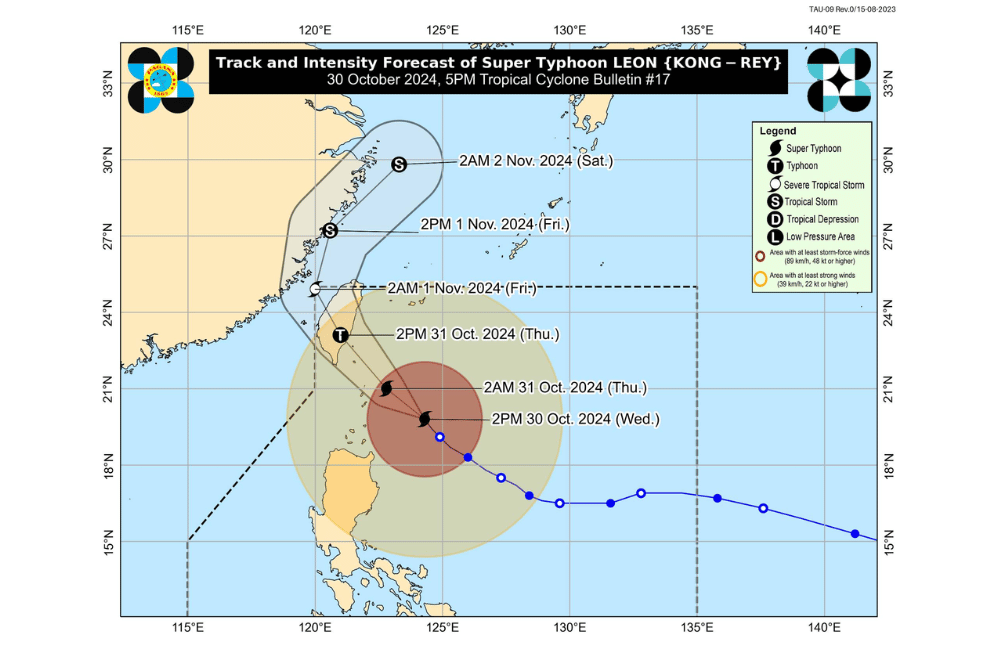
Super Typhoon #LeonPH continues to move northwestward toward Batanes, the Philippine Atmospheric, Geophysical and Astronomical Services Administration (PAGASA) reported.
As of 5:00 p.m. on October 30, 2024, the eye of #LeonPH was located approximately 215 km east-southeast of Basco, Batanes.
The storm is advancing at a speed of 20 km/h in a northwestward direction.
Currently, #LeonPH has maximum sustained winds of 185 km/h near its center, with gusts reaching up to 230 km/h.
Tropical Cyclone Wind Signal No. 4 has been raised over:
- Batanes
Tropical Cyclone Wind Signal No. 3 has been raised over:
- Eastern Babuyan Islands (Babuyan Island, Camiguin Island, Calayan Island)
- Northeastern mainland Cagayan (Santa Ana)
Tropical Cyclone Wind Signal No. 2 has been raised over:
- The rest of Babuyan Islands
- The rest of mainland Cagayan
- The northern portion of Isabela (Santo Tomas, Santa Maria, Quezon, Delfin Albano, San Pablo, Ilagan City, Tumauini, Cabagan, Palanan, Quirino, Divilacan, Mallig, Maconacon, Gamu, Burgos, Roxas, San Mariano, Reina Mercedes, San Manuel, Naguilian, Benito Soliven)
- Apayao
- Kalinga
- Northern and eastern Abra (Tineg, Lacub, Malibcong, Lagayan, San Juan, Lagangilang, Licuan-Baay, Daguioman)
- Eastern Mountain Province (Paracelis)
- Ilocos Norte
Tropical Cyclone Wind Signal No. 1 has been raised over:
- The rest of Isabela
- Quirino
- Nueva Vizcaya
- The rest of Mountain Province
- Ifugao
- Benguet
- The rest of Abra
- Ilocos Sur
- La Union
- Pangasinan
- Nueva Ecija
- Aurora
- Northeastern Tarlac (Camiling, San Clemente, Paniqui, Moncada, Anao, San Manuel, Pura, Ramos, Victoria, Gerona, Santa Ignacia, City of Tarlac, La Paz)
Severe Winds
Winds are expected to be most severe in areas under Wind Signal No. 4, with significant impacts likely. Moderate to significant impacts from storm-force winds are possible in Wind Signal No. 3 areas, while minor to moderate impacts are anticipated in Wind Signal No. 2 areas. A Wind Signal No. 5 is not ruled out if #LeonPH shifts leftward.
Coastal Inundation
Life-threatening coastal flooding due to storm surges of over 3.0 meters above normal tides is anticipated in low-lying areas of Batanes and Babuyan Islands.
Hazards Affecting Coastal Waters
Gale Warnings are in effect for Northern Luzon’s seaboards and eastern Central and Southern Luzon. Rough to very rough seas, with waves reaching up to 14.0 meters, make sea travel hazardous for all vessel types.
Track and Intensity Outlook
#LeonPH is expected to make landfall along Taiwan's eastern coast on October 31 and will approach Batanes closely tonight until tomorrow morning. The typhoon is expected to weaken after landfall and may exit the Philippine Area of Responsibility by early November 1.
PAGASA advises the public to stay updated on further advisories and to take necessary precautions as #LeonPH progresses.


