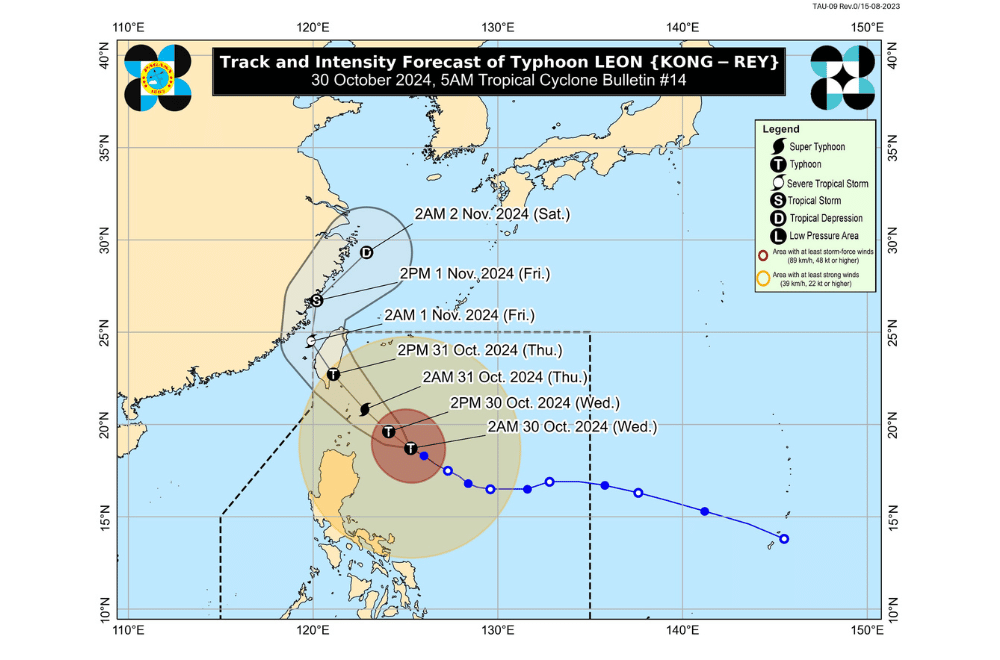
#LeonPH has intensified into a super typhoon while moving closer to Extreme Northern Luzon, according to the Philippine Atmospheric, Geophysical and Astronomical Services Administration (PAGASA).
As of 11:00 a.m. on October 30, 2024, the center of #LeonPH was located approximately 350 km east of Calayan, Cagayan.
The super typhoon is moving at a speed of 10 km/h in a west-northwestward direction.
Currently, it has maximum sustained winds of 185 km/h near its center, with gustiness reaching up to 230 km/h.
Tropical Cyclone Wind Signal No. 3 has been raised over:
- Batanes
- The eastern portion of Babuyan Islands (Babuyan Is., Camiguin Is., Calayan Is.)
- The northeastern portion of mainland Cagayan (Santa Ana)
Tropical Cyclone Wind Signal No. 2 has been raised over:
- The rest of Babuyan Islands
- The rest of mainland Cagayan
- The northern and eastern portions of Isabela (Santo Tomas, Santa Maria, Quezon, San Mariano, Naguilian, Dinapigue, Delfin Albano, San Pablo, Ilagan City, Benito Soliven, Tumauini, Cabagan, Palanan, Quirino, Divilacan, Gamu, Mallig, Maconacon, Burgos, City of Cauayan, San Guillermo, Angadanan, Cabatuan, Luna, Reina Mercedes, Roxas, Aurora, San Manuel)
- Apayao
- Kalinga
- The northern and eastern portions of Abra (Tineg, Lacub, Malibcong, Lagayan, San Juan, Lagangilang, Licuan-Baay, Daguioman)
- The eastern portion of Mountain Province (Paracelis)
- Ilocos Norte
Tropical Cyclone Wind Signal No. 1 has been raised over:
- The rest of Isabela
- Quirino
- Nueva Vizcaya
- The rest of Mountain Province
- Ifugao
- Benguet
- The rest of Abra
- Ilocos Sur
- La Union
- Pangasinan
- Nueva Ecija
- Aurora
- The northeastern portion of Tarlac (Camiling, San Clemente, Paniqui, Moncada, Anao, San Manuel, Pura, Ramos, Victoria, Gerona, Santa Ignacia, City of Tarlac, La Paz)
- The northern portion of Bulacan (Doña Remedios Trinidad, San Miguel)
- The northern portion of Quezon (Infanta, General Nakar) including Polillo Islands
- Camarines Norte
- The northern portion of Camarines Sur (Siruma, Tinambac, Lagonoy, Garchitorena, Caramoan)
- The northern and eastern portions of Catanduanes (Pandan, Gigmoto, Bagamanoc, Panganiban, Viga, Baras, Caramoran)
Severe Winds
PAGASA has warned that strong to destructive winds are expected in areas under TCWS No. 1, 2, and 3, with stronger gusts in coastal and upland areas. There is a possibility of raising Wind Signal No. 4 over Batanes later today due to potentially destructive winds. Gusty conditions from LEON will also be felt in areas including Metro Manila, CALABARZON, MIMAROPA, and Visayas.
Coastal Inundation
A storm surge warning has been issued with expected surge heights of 2.0 to 3.0 meters over low-lying coastal areas of Batanes and Babuyan Islands.
Hazards Affecting Coastal Waters
Gale Warnings are in effect for seaboards in Northern, Central, and Southern Luzon. Sea travel remains risky for all vessel types in affected waters.
Track and Intensity Outlook
#LeonPH is forecast to continue moving northwestward, with a projected landfall along Taiwan’s eastern coast by tomorrow afternoon, October 31. It may pass closest to Batanes between tonight and tomorrow morning. Further weakening is expected after landfall in Taiwan.
PAGASA advises the public to stay updated on further advisories and take necessary precautions as #LeonPH progresses.


