

Severe Tropical Storm #LeonPH has further intensified while moving west northwestward over the Philippine Sea, according to the Philippine Atmospheric, Geophysical and Astronomical Services Administration (PAGASA).
As of 5:00 p.m. on October 28, 2024, the center of "Leon" was located 725 km east of Echague, Isabela.
The storm is moving at a speed of 15 km/h in a west northwestward direction.
The storm currently has maximum sustained winds of 100 km/h near its center, with gustiness reaching up to 125 km/h.
Tropical Cyclone Wind Signal No. 1 has been raised over:
Luzon:
- Batanes
- Cagayan, including Babuyan Islands
- Isabela
- Quirino
- Nueva Vizcaya
- Apayao
- Kalinga
- Abra
- Mountain Province
- Ifugao
- The northern portion of Benguet (Bakun, Kibungan, Atok, Bokod, Mankayan, Buguias, Kabayan)
- Ilocos Norte
- Ilocos Sur
- La Union
- Aurora
- The northern portion of Quezon, including Polillo Islands (General Nakar, Infanta, Real)
- Camarines Norte
- The eastern portion of Camarines Sur (Tinambac, Siruma, Goa, Lagonoy, San Jose, Garchitorena, Caramoan, Presentacion, Tigaon, Calabanga, Saglay)
- Catanduanes
- The eastern portion of Albay (Rapu-Rapu, Bacacay, City of Tabaco, Tiwi, Malilipot, Malinao, Santo Domingo, Manito)
- The northeastern portion of Sorsogon (Prieto Diaz, City of Sorsogon, Gubat)
Visayas:
- The eastern portion of Northern Samar (San Roque, Pambujan, Catubig, Laoang, Palapag, Gamay, Lapinig, Mapanas, Mondragon)
- The northern portion of Eastern Samar (Jipapad, Arteche, Oras, San Policarpo)
Severe Winds:
The wind signals warn the public of a general wind threat over areas affected by the tropical cyclone. Local winds may be slightly stronger in coastal and upland/mountainous areas exposed to the prevailing wind direction. Minimal to minor impacts from strong winds are possible within any of the areas under Wind Signal No. 1. The highest wind signal that may be hoisted during "Leon" is Wind Signal No. 3 or 4, especially in Extreme Northern Luzon. The hoisting of Wind Signal No. 5 is also not ruled out.
Furthermore, gusty conditions (strong to gale-force) are expected in the following localities outside Wind Signal areas:
- Today (October 28): Visayas, most of CALABARZON, MIMAROPA, Bicol Region, Northern Mindanao, and Caraga Region.
- Tomorrow (October 29): Zambales, Bataan, Aurora, Metro Manila, CALABARZON, MIMAROPA, Bicol Region, Visayas, Dinagat Islands, Surigao del Norte, and Camiguin.
- Wednesday (October 30): Zambales, Bataan, Aurora, Metro Manila, CALABARZON, MIMAROPA, Bicol Region, Dinagat Islands, and most of Visayas and Central Luzon.
Hazards Affecting Coastal Waters:
A Gale Warning will be hoisted over the northern and eastern seaboards of Northern Luzon this afternoon.
24-Hour Sea Condition Outlook:
- Very Rough Seas (up to 5.5 m): The seaboards of Batanes and Babuyan Islands
- Very Rough Seas (up to 5.0 m): The eastern seaboards of mainland Cagayan and Isabela
Sea travel is risky for all types or tonnage of vessels. Mariners must remain in port or seek shelter as soon as possible until winds and waves subside.
- Rough Seas (up to 4.0 m): The northern and eastern seaboards of Catanduanes; the northern seaboard of Ilocos Norte
- Rough Seas (up to 3.5 m): The northern and eastern seaboards of Polillo Islands; the northern seaboards of Camarines Norte and Camarines Sur
- Rough Seas (up to 3.0 m): The seaboard of Aurora; the eastern seaboards of Albay and Sorsogon; the northern and eastern seaboards of Northern Samar; the remaining seaboard of Ilocos Norte
Mariners of small seacrafts, including all types of motorbancas, are advised not to venture out to sea under these conditions, especially if inexperienced or operating ill-equipped vessels.
- Moderate Seas (up to 2.5 m): The seaboard of Ilocos Sur; the eastern seaboard of mainland Quezon, Camarines Sur, Eastern Samar, and Dinagat Islands
- Moderate Seas (up to 2.0 m): The remaining seaboards of the country
Mariners of motorbancas and similarly sized vessels are advised to take precautionary measures while venturing out to sea and, if possible, avoid navigation under these conditions.
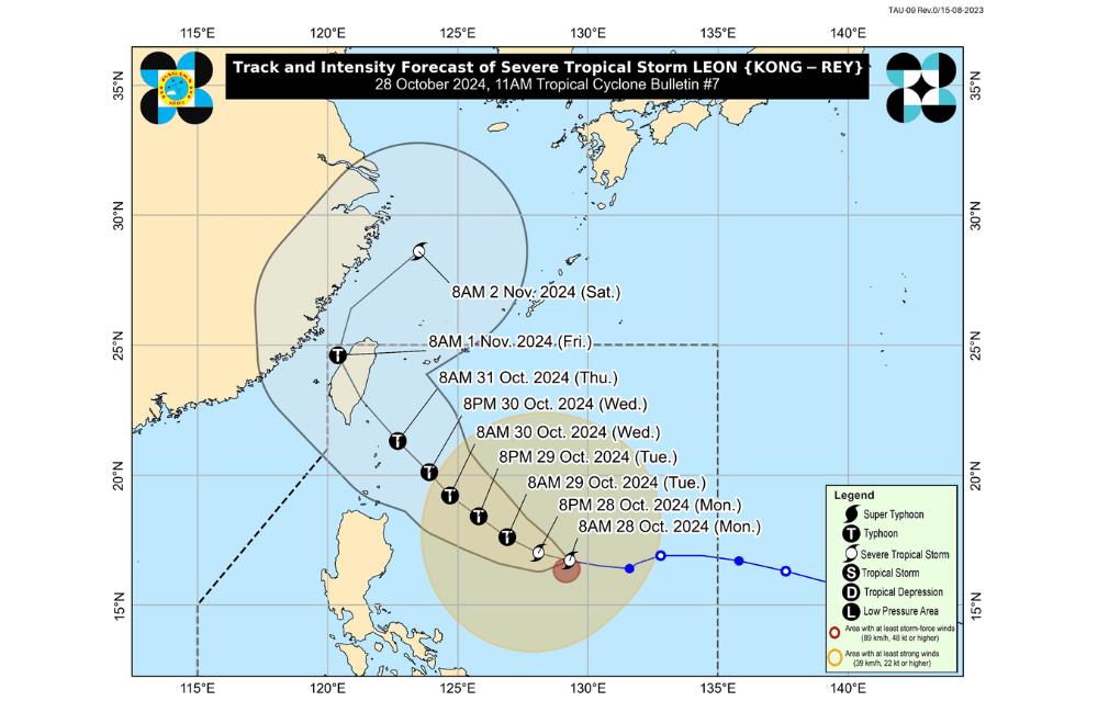
Track and Intensity Outlook:
"Leon" is forecast to move west northwestward today through tomorrow morning (October 29), then turn northwestward until it makes landfall along the eastern coast of Taiwan on Thursday (October 31) afternoon or evening. After crossing Taiwan, "Leon" will turn northeast towards the East China Sea and exit the Philippine Area of Responsibility on Friday morning or afternoon.
There is an increasing possibility of a further westward shift in the track forecast of "Leon," but this remains within the limits of the forecast confidence cone. A landfall or close approach scenario on Batanes is not ruled out. This tropical cyclone is expected to rapidly intensify throughout its passage over the Philippine Sea and may reach typhoon category within 24 hours. Furthermore, there is an increasing chance that "Leon" will reach super typhoon category during its period of closest approach to Batanes.
PAGASA advises the public to stay updated on further advisories and take necessary precautions as "Leon" progresses.
