

Severe Tropical Storm #LeonPH has strengthened further while moving westward over the Philippine Sea, according to the Philippine Atmospheric, Geophysical and Astronomical Services Administration (PAGASA).
As of 10:00 AM on October 28, 2024, the center of #LeonPH was located approximately 735 km east of Casiguran, Aurora, or 780 km east of Echague, Isabela.
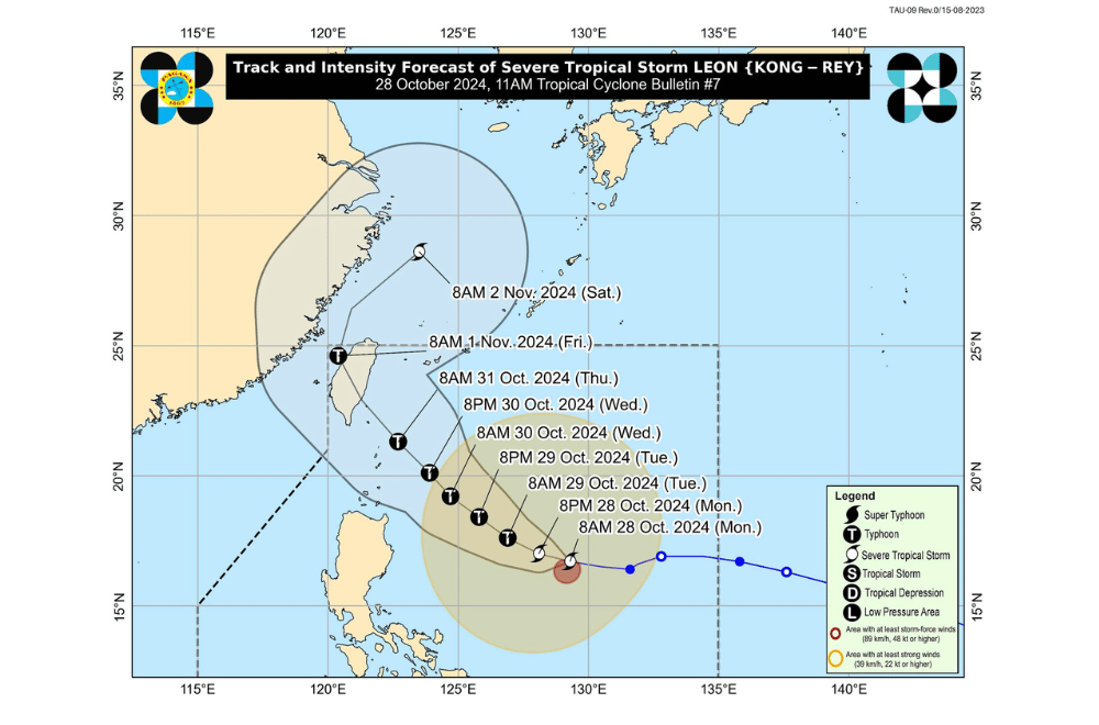
The storm is moving at a speed of 20 km/h in a westward direction.
Currently, #LeonPH has maximum sustained winds of 95 km/h near its center, with gusts reaching up to 115 km/h.
Tropical Cyclone Wind Signal No. 1 has been raised over:
- Batanes
- Cagayan (including Babuyan Islands)
- Isabela
- Ilocos Norte
- Abra
- Apayao
- Kalinga
- Eastern Mountain Province (Natonin, Paracelis)
- Eastern Ifugao (Aguinaldo, Alfonso Lista)
- Eastern Quirino (Maddela)
- Northern Aurora (Dilasag, Casiguran, Dinalungan)
- Northern Catanduanes (Pandan, Bagamanoc, Panganiban, Viga, Gigmoto).
Severe Winds:
Strong to gale-force winds are expected in areas under TCWS No. 1, with possible stronger gusts in coastal and mountainous areas. Winds may be intensified in regions exposed to the storm’s circulation.
Hazards Affecting Coastal Waters:
A Gale Warning is expected to be hoisted over the northern and eastern seaboards of Northern Luzon this afternoon.
Sea Condition Forecast (24-Hour):
- Very Rough Seas: Up to 5.5 m in the seaboards of Batanes and Babuyan Islands; up to 5.0 m in the eastern seaboards of mainland Cagayan and Isabela.
- Rough Seas: Up to 4.0 m in the northern and eastern seaboards of Catanduanes and northern Ilocos Norte; up to 3.5 m in the northern and eastern seaboards of Polillo Islands, Camarines Norte, and Camarines Sur.
- Moderate Seas: Up to 2.5 m in the seaboard of Ilocos Sur and eastern seaboard of mainland Quezon, Camarines Sur, Eastern Samar, and Dinagat Islands.
Mariners and small seacrafts are advised to avoid sea travel as conditions may pose risks.
Track and Intensity Outlook:
#LeonPH is forecast to move west-northwestward until tomorrow morning (October 29) before turning northwestward toward Taiwan by Thursday (October 31) evening or Friday (November 1) early morning.
PAGASA warns that the storm could intensify further, reaching typhoon category within the next 24 hours and possibly super typhoon strength near Batanes.
The public is advised to stay updated on further advisories and take precautionary measures as Severe Tropical Storm #LeonPH progresses.
