

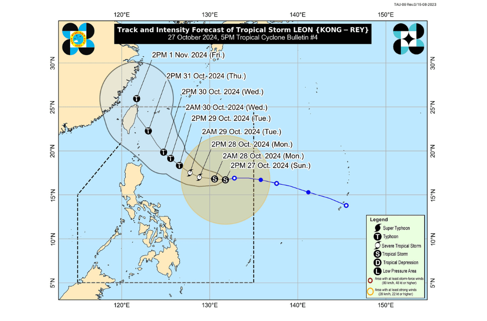
Tropical Storm #LeonPH slightly intensifies and is currently moving westward over the Philippine Sea, according to the Philippine Atmospheric, Geophysical and Astronomical Services Administration (PAGASA).
As of 4:00 p.m. on October 27, 2024, the center of Tropical Storm Leon was estimated to be located 1,000 km east of Central Luzon, at coordinates 16.7°N and 131.5°E.
The storm is moving at a speed of 20 km/h in a westward direction.
It currently has maximum sustained winds of 75 km/h near its center, with gustiness reaching up to 90 km/h and a central pressure of 992 hPa.
No Tropical Cyclone Wind Signal is effect.
Other Hazards Affecting Land Areas:
Heavy Rainfall Outlook:
As Tropical Storm Leon moves north-northwestward over the Philippine Sea, its outer rainbands may begin to affect Extreme Northern Luzon. Additionally, it may influence the Southwesterly Windflow initially triggered by Tropical Storm Trami (formerly “Kristine”), which could impact the Visayas, Mindanao, and the western section of Southern Luzon. A weather advisory may be issued in the coming hours.
Severe Winds:
Tropical Cyclone Wind Signal No. 1 may be raised over portions of Cagayan Valley and the northeastern portion of the Bicol Region by tonight or tomorrow. The highest wind signal that may be hoisted during Tropical Storm Leon's approach could be Wind Signal No. 1 or 2, depending on the storm's proximity.
Gusty conditions (strong to gale-force winds) are expected in the following areas, particularly in coastal and upland regions:
- Today (October 27): Palawan, Romblon, Catanduanes, Sorsogon, Masbate, most of Visayas, Dinagat Islands, Surigao del Norte, and Camiguin.
- Tomorrow (October 28): Batanes, Babuyan Islands, Batangas, most of MIMAROPA, most of the Bicol Region, Visayas, most of Northern Mindanao, and most of Caraga Region.
- Tuesday (October 29): Aurora, Metro Manila, CALABARZON, MIMAROPA, Bicol Region, Visayas, Dinagat Islands, Surigao del Norte, and Camiguin.
Hazards Affecting Coastal Waters:
24-Hour Sea Condition Outlook:
Rough seas are expected over the following coastal waters:
- Up to 4.0 m: The seaboard of Batanes.
- Up to 3.0 m: The seaboards of Kalayaan Islands and Babuyan Islands; the northern and eastern seaboards of mainland Cagayan Valley and Catanduanes.
Mariners of small seacrafts, including all types of motorbancas, are advised not to venture out to sea under these conditions, especially if inexperienced or operating ill-equipped vessels.
Moderate seas are expected over the following coastal waters:
- Up to 2.5 m: The western seaboard of Palawan, Batangas, Bataan, and Zambales; the seaboards of Occidental Mindoro, Pangasinan, La Union, Ilocos Sur, Ilocos Norte, Aurora, northern mainland Quezon, and Camarines Norte; the northern and eastern seaboards of Polillo Islands, Camarines Sur, and Northern Samar; the eastern seaboards of Albay, Sorsogon, and Eastern Samar.
- Up to 2.0 m: The eastern seaboard of Dinagat Islands.
Mariners of motorbancas and similarly-sized vessels are advised to take precautionary measures while venturing out to sea and, if possible, to avoid navigation under these conditions.
PAGASA advises the public to stay updated on further advisories and take necessary precautions as Tropical Storm #LeonPH progresses.
