

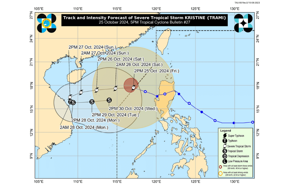
Severe Tropical Storm #KristinePH has accelerated while moving west northwestward outside the Philippine Area of Responsibility (PAR), according to the Philippine Atmospheric, Geophysical and Astronomical Services Administration (PAGASA).
As of 5:00 p.m. on October 25, 2024, the center of #KristinePH was located 410 km west of Sinait, Ilocos Sur (17.7 °N, 116.6 °E).
The storm is moving at a speed of 30 km/h in a west northwestward direction.
The storm currently has maximum sustained winds of 95 km/h near its center, with gustiness reaching up to 115 km/h.
Tropical Cyclone Wind Signal No. 1 has been raised over:
- Ilocos Norte
- Ilocos Sur
- La Union
- Pangasinan
- Apayao
- Kalinga
- Abra
- Mountain Province
- Ifugao
- Benguet
- Cagayan including Babuyan Islands
- Isabela
- Quirino
- Nueva Vizcaya
- Nueva Ecija
- Tarlac
- Zambales
- Bataan
- Pampanga
- Bulacan
- Metro Manila
- The northern portion of Rizal (Cainta, Rodriguez, San Mateo, City of Antipolo, Taytay)
- The northern portion of Cavite (Ternate, Naic, Tanza, Rosario, Bacoor City, Kawit, Noveleta, Cavite City, City of General Trias, Imus City, Maragondon)
The wind signals warn the public of the general wind threat over an area due to the tropical cyclone. Local winds may be slightly stronger/enhanced in coastal and upland/mountainous areas exposed to winds. Minimal to minor impacts from strong winds are possible within any of the areas under Wind Signal No. 1.
Furthermore, the southwesterly wind flow triggered by both Kristine and Tropical Storm Kong-Rey outside the PAR region will also bring strong to gale-force gusts over the following areas:
- Today (25 October): MIMAROPA, Bicol Region, Visayas, Dinagat Islands, Surigao del Norte, Northern Mindanao, Zamboanga Peninsula, BARMM, SOCCSKSARGEN, and Davao Region.
- Tomorrow (26 October): Palawan, Romblon, Western Visayas, Negros Island Region, Siquijor, Bohol, Southern Leyte, Zamboanga del Norte, Camiguin, Dinagat Islands, and Surigao del Norte.
- Sunday (27 October): Palawan, Romblon, Visayas, Zamboanga del Norte, Camiguin, Dinagat Islands, and Surigao del Norte.
Coastal Inundation:
All storm surge warnings have been lifted.
Hazards Affecting Coastal Waters:
A Gale Warning is hoisted over the northern and western seaboards of Luzon.
24-Hour Sea Condition Outlook:
- Up to very rough or high seas over the following coastal waters:
- Up to 6.0 m: The western seaboards of Pangasinan, Zambales, and Bataan.
- Up to 5.5 m: The remaining seaboard of Pangasinan; the seaboard of Batanes, Babuyan Islands, and La Union.
- Up to 5.0 m: The remaining seaboard of Ilocos Region; the eastern seaboard of mainland Cagayan; the seaboard of Lubang Islands; the western seaboards of Bataan and Batangas.
- Up to 4.5 m: The seaboards of Occidental Mindoro; the northern and western seaboards of Calamian Islands.
Sea travel is risky for all types or tonnage of vessels. All mariners must remain in port or, if underway, seek shelter or safe harbor as soon as possible until winds and waves subside.
- Up to rough seas over the following coastal waters:
- Up to 4.0 m: The remaining seaboard of Cagayan Valley; the western seaboard of mainland Palawan; the seaboard of Kalayaan Islands.
- Up to 3.5 m: The seaboards of Cuyo Islands, Calamian Islands, Antique, and northern Aurora; the southern seaboard of Iloilo; the western and southern seaboards of Guimaras; the western and southern seaboard of Negros Occidental.
- Up to 3.0 m: The remaining seaboards of Aurora and Batangas; the seaboards of Oriental Mindoro, Marinduque, Romblon, Camarines Norte; the northern seaboard of Camarines Sur, the northern and eastern seaboards of Polillo Islands and Catanduanes; the southern seaboard of mainland Quezon.
Mariners of small seacrafts, including all types of motorbancas, are advised not to venture out to sea under these conditions, especially if inexperienced or operating ill-equipped vessels.
- Up to moderate seas over the following coastal waters:
- Up to 2.5 m: The seaboard of Northern Mindanao, Zamboanga del Norte, and Siquijor, the southern seaboard of Bohol, the eastern seaboards of Albay, Sorsogon, Eastern Samar, Dinagat Islands, Surigao del Sur, and Davao Oriental, the northern and eastern seaboards of Northern Samar.
Mariners of motorbancas and similarly-sized vessels are advised to take precautionary measures while venturing out to sea and, if possible, avoid navigation under these conditions.
Track and Intensity Outlook:
#KristinePH will continue moving westward over the West Philippine Sea until tomorrow, looping counterclockwise on Sunday and Monday, then moving eastward for the remainder of the forecast period. However, this scenario heavily depends on the behavior of the tropical cyclone east of the PAR region and the behavior of other synoptic weather systems surrounding Kristine while over the West Philippine Sea.
This tropical cyclone is forecast to gradually intensify over the West Philippine Sea. While it is likely that the tropical cyclone will remain at severe tropical storm category within the next two days, the chance for it to be upgraded into a typhoon is not ruled out. However, a weakening trend is expected by early next week due to a possible surge of northeasterly wind flow over the West Philippine Sea.
PAGASA advises the public to stay updated on further advisories and take necessary precautions as #KristinePH progresses.
