

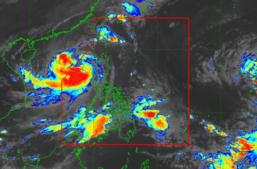
Severe Tropical Storm #KristinePH is about to exit the Philippine Area of Responsibility (PAR) as it continues to move west-northwestward, according to the latest update from the Philippine Atmospheric, Geophysical and Astronomical Services Administration (PAGASA).
As of 11:00 a.m. on October 25, 2024, the center of #KristinePH was located 255 km west-northwest of Bacnotan, La Union, or 255 km west-southwest of Sinait, Ilocos Sur.
The storm is moving at a speed of 15 km/h in a west-northwestward direction.
It currently has maximum sustained winds of 95 km/h near its center, with gustiness reaching up to 115 km/h.
Tropical Cyclone Wind Signal No. 2 has been raised over:
- The northwestern portion of mainland Cagayan (Santa Praxedes, Claveria, Sanchez-Mira, Abulug, Pamplona)
- The Babuyan Islands
- Nueva Vizcaya
- Apayao
- Abra
- Kalinga
- Mountain Province
- Ifugao
- Benguet
- Ilocos Norte
- Ilocos Sur
- La Union
- Pangasinan
- Nueva Ecija
- Tarlac
- Pampanga
- Zambales
- The northern portion of Bataan (Morong, Hermosa, Dinalupihan, Bagac, Orani, Samal, Abucay, Balanga City)
Tropical Cyclone Wind Signal No. 1 has been raised over:
Luzon:
- Batanes
- The rest of mainland Cagayan
- Isabela
- Quirino
- Aurora
- Bulacan
- The rest of Bataan
- Metro Manila
- Cavite
- Batangas
- Laguna
- Rizal
- Quezon
- Occidental Mindoro
- Oriental Mindoro
- Marinduque
- Romblon
- The northern portion of Palawan (El Nido, Taytay, San Vicente, Dumaran, Araceli), including Calamian, Cuyo, and Kalayaan Islands
- Camarines Norte
- Camarines Sur
- Burias Island
Visayas:
- The northern portion of Aklan (Buruanga, Malay, Nabas, Ibajay)
- The northern portion of Antique (Libertad, Pandan), including Caluya Islands
Heavy Rainfall Outlook:
PAGASA advises to refer to Weather Advisory No. 27 issued at 11:00 AM today for the heavy rainfall outlook due to #KristinePH.
Severe Winds:
Areas under TCWS No. 2 and 1 should expect strong winds with minor to moderate impacts in areas under Signal No. 2 and minimal to minor impacts in areas under Signal No. 1. Local winds in coastal and upland areas may be stronger.
Winds will be enhanced in the following regions:
- Today (25 October): MIMAROPA, Bicol Region, Visayas, Dinagat Islands, Surigao del Norte, Northern Mindanao, Zamboanga Peninsula, BARMM, SOCCSKSARGEN, Davao Region
- Tomorrow (26 October): Palawan, Siquijor, Bohol, Southern Leyte, Zamboanga del Norte, Camiguin, Dinagat Islands, Surigao del Norte
- Sunday (27 October): Palawan, Romblon, Visayas, Siquijor, Bohol, Southern Leyte, Zamboanga del Norte, Camiguin, Dinagat Islands, Surigao del Norte
Hazards Affecting Coastal Waters:
A Gale Warning is in effect over the seaboards of Luzon and the western seaboard of Visayas. Sea travel is considered risky for all types of vessels due to rough seas up to 6.0 meters in some areas.
Track and Intensity Outlook:
Severe Tropical Storm #KristinePH is expected to exit PAR this afternoon or evening. It will continue moving westward over the West Philippine Sea and is forecast to gradually intensify. However, a possible weakening trend may occur early next week due to the northeasterly wind surge.
The public is advised to stay updated with PAGASA’s upcoming bulletins and advisories as #KristinePH continues its course over the West Philippine Sea.
