

Severe Tropical Storm #KristinePH has moved westward, positioning itself over the coastal waters of Southern Ilocos Sur, as reported by the Philippine Atmospheric, Geophysical, and Astronomical Services Administration (PAGASA).
As of 5:00 p.m. on October 24, 2024, the center of #KristinePH was located over the coastal waters of Santa Lucia, Ilocos Sur.
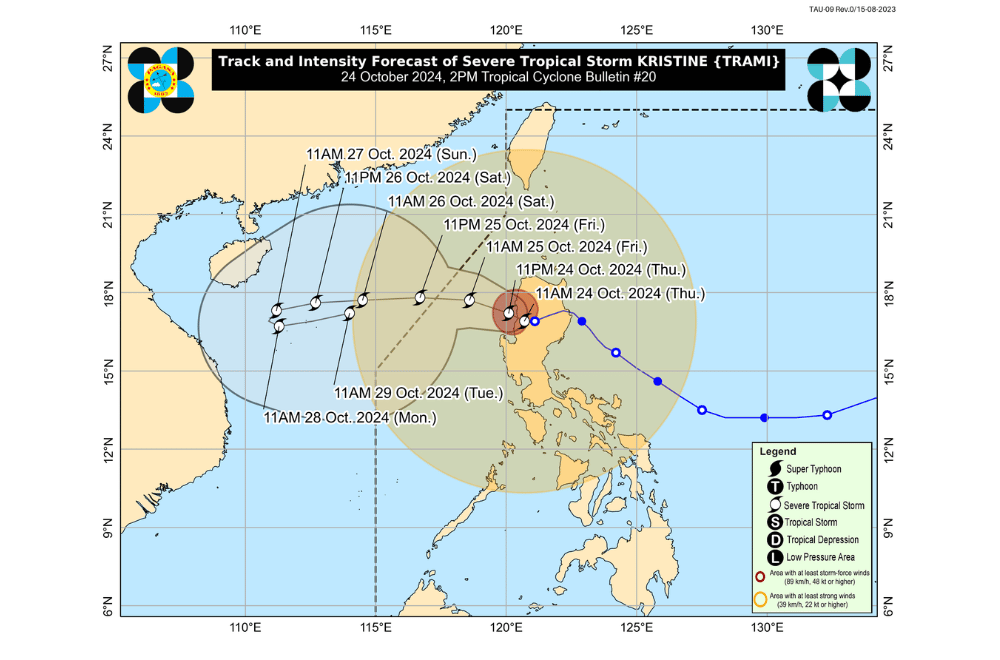
The storm is currently moving westward at a slow pace.
The storm holds maximum sustained winds of 95 km/h near its center, with gustiness reaching up to 115 km/h.
Tropical Cyclone Wind Signal No. 3 has been raised over:
- Ilocos Sur
- La Union
- Pangasinan
Tropical Cyclone Wind Signal No. 2 has been raised over:
- Cagayan including Babuyan Islands
- Isabela
- Quirino
- Nueva Vizcaya
- Apayao
- Kalinga
- Abra
- Ifugao
- Mountain Province
- Benguet
- Ilocos Norte
- Aurora
- Nueva Ecija
- Tarlac
- Zambales
- Bataan
- Pampanga
- Bulacan
Tropical Cyclone Wind Signal No. 1 has been raised over:
- Batanes
- Metro Manila
- Rizal
- Batangas
- Laguna
- Cavite
- Quezon
- Occidental Mindoro
- Oriental Mindoro
- Marinduque
- Romblon
- The northern portion of mainland Palawan (El Nido, Taytay, Araceli, San Vicente, Dumaran, Roxas) including Calamian Islands, Cuyo, and Kalayaan Islands
- Camarines Norte
- Camarines Sur
- Catanduanes
- Albay
- Sorsogon
- Masbate including Ticao and Burias Islands
Residents in areas under Wind Signal Nos. 3, 2, and 1 are warned of varying levels of wind impact. Moderate to significant impacts are possible where Wind Signal No. 3 is raised, while minor to moderate impacts can be expected in areas under Signal No. 2. Minimal impacts are expected in regions under Signal No. 1.
Strong to gale-force gusts are forecast in coastal and upland areas throughout Luzon, Visayas, and Mindanao. Strong winds are also expected to affect areas outside of the wind signal zones, particularly exposed areas.
Coastal Inundation:
PAGASA has warned of storm surges reaching 1.0 to 2.0 meters over low-lying areas of Ilocos Sur, La Union, Pangasinan, Cagayan, Isabela, Aurora, and Zambales in the next 48 hours. Residents in these areas are advised to remain cautious.
Hazards Affecting Coastal Waters:
A Gale Warning is in effect over the seaboards of Luzon and parts of Visayas. Rough to very rough seas are expected, with wave heights ranging from 3.0 to 7.0 meters. All types of vessels are advised to stay in port until the sea conditions improve.
Track and Intensity Outlook:
#KristinePH is expected to continue its westward movement over the West Philippine Sea, exiting the Philippine Area of Responsibility (PAR) by the afternoon of October 25. There is a possibility of #KristinePH re-intensifying over the West Philippine Sea, and while it is likely to remain a severe tropical storm, there is still a chance for it to develop into a typhoon in the coming days.
PAGASA advises the public to stay updated with further advisories as #KristinePH progresses.
