


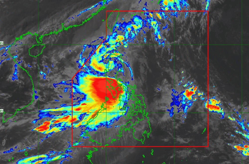
Severe Tropical Storm #KristinePH is now over the Cordillera Administrative Region, according to the latest update from the Philippine Atmospheric, Geophysical and Astronomical Services Administration (PAGASA).
As of 11:00 a.m. on October 24, 2024, the center of #KristinePH was located near Aguinaldo, Ifugao (17.0 °N, 121.3 °E).
The storm is moving westward at a speed of 20 km/h.
#KristinePH currently has maximum sustained winds of 95 km/h near its center, with gustiness reaching up to 115 km/h.
Tropical Cyclone Wind Signal No. 3 has been raised over:
- Mountain Province
- Ifugao
- Benguet
- The northern portion of Nueva Vizcaya (Bayombong, Ambaguio, Bagabag, Villaverde, Kayapa, Bambang, Diadi, Quezon, Solano, Santa Fe, Aritao)
- The southern portion of Ilocos Sur (Cervantes, Quirino, Sigay, Suyo, Alilem, Sugpon, Tagudin, Santa Cruz, Salcedo, Gregorio del Pilar, San Emilio, Lidlidda, Burgos, San Esteban, Santiago, Banayoyo, Galimuyod, City of Candon, Santa Lucia, Nagbukel, Santa Maria, Narvacan)
- La Union
- Pangasinan
Tropical Cyclone Wind Signal No. 2 has been raised over:
- Cagayan including Babuyan Islands
- Isabela
- Quirino
- The rest of Nueva Vizcaya
- Apayao
- Kalinga
- Abra
- Ilocos Norte
- The rest of Ilocos Sur
- Nueva Ecija
- Aurora
- Bulacan
- Tarlac
- Pampanga
- Zambales
- Bataan
- Metro Manila
- Rizal
- Cavite
- The western portion of Batangas (Lian, Nasugbu, Tuy, Calatagan, Balayan)
- The northern portion of Quezon (Real, Infanta, General Nakar) including Polillo Islands
- The northern portion of Laguna (Cabuyao City, City of Santa Rosa, City of Bisan, City of San Pedro, Pakil, Mabitac, Pangil, Santa Maria, Siniloan, Famy)
- Lubang Islands
Tropical Cyclone Wind Signal No. 1 has been raised over:
Luzon
- Batanes
- The rest of Batangas
- The rest of Laguna
- The rest of Quezon
- The rest of Occidental Mindoro
- Oriental Mindoro
- Marinduque
- Romblon
- The northern portion of mainland Palawan (El Nido, Taytay, Araceli, San Vicente, Dumaran, Roxas) including Calamian Islands, Cuyo, and Kalayaan Islands
- Camarines Norte
- Camarines Sur
- Catanduanes
- Albay
- Sorsogon
- Masbate including Ticao and Burias Islands
Visayas
- Aklan
- Capiz
- Antique including Caluya Islands
- Iloilo
- Bantayan Islands
- Northern Samar
- The northern portion of Samar (Calbayog City, Santo Nino, Almagro, Tagapul-An, San Jorge, Matuguinao, Jiabong, Pagsanghan, City of Catbalogan, Gandara, Motiong, San Jose de Buan, Santa Margarita, Tarangnan, Daram, Zumarraga)
- Biliran
- The northern portion of Eastern Samar (Maslog, Jipapad, Arteche, Oras, San Policarpo)
- The northwestern portion of Leyte (Calubian, San Isidro)
Heavy Rainfall Outlook:
Refer to Weather Advisory No. 19 issued at 8:00 AM today for the heavy rainfall outlook due to #KristinePH
Severe Winds:
The wind signals warn the public of the general wind threat over the area due to the tropical cyclone. Local winds may be slightly stronger in coastal and upland/mountainous areas exposed to winds. Moderate to significant impacts from storm-force winds are possible where Wind Signal No. 3 is hoisted. Minor to moderate impacts from gale-force winds are expected where Wind Signal No. 2 is hoisted. Minimal to minor impacts from strong winds are anticipated in areas under Wind Signal No. 1.
Furthermore, the wind flow coming towards the circulation of #KristinePH and the Northeasterly Windflow will bring strong to gale-force gusts over MIMAROPA, Bicol Region, Visayas, Basilan, Sulu, Tawi-Tawi, Zamboanga del Norte, Lanao del Sur, Northern Mindanao, Dinagat Islands, Surigao del Norte, Davao del Sur, and Davao Oriental today.
Coastal Inundation:
There is a minimal to moderate risk of life-threatening storm surge up to 2.0 meters above normal tide levels in the next 48 hours over low-lying or exposed coastal localities of Ilocos Norte, Ilocos Sur, La Union, Pangasinan, Cagayan, Isabela, Aurora, and Zambales. For more information, refer to Storm Surge Warning No. 9 issued at 8:00 AM today.
Hazards Affecting Coastal Waters:
A Gale Warning is in effect for the seaboards of Luzon and Visayas. For more information, refer to Gale Warning No. 8 issued at 5:00 AM today.
24-Hour Sea Condition Outlook:
- Up to very rough or high seas over the following coastal waters:
- Up to 8.0 m: The seaboards of Ilocos Region, and Zambales; the western seaboards of Batanes and Babuyan Islands.
- Up to 7.0 m: The western seaboard of Bataan; the remaining seaboard of Cagayan Valley.
- Up to 6.0 m: The western seaboards of Batangas; the seaboard of Lubang Island.
- Up to 5.5 m: The western seaboards of Occidental Mindoro and Calamian Islands.
- Up to 4.5 m: The seaboards of Aurora; the northern and eastern seaboards of Catanduanes; the northern seaboard of Camarines Sur; the western seaboard of Western Visayas, Negros Occidental, and mainland Palawan.
Sea travel is risky for all types of vessels. Mariners are advised to remain in port or seek shelter as soon as possible until conditions improve.
- Up to rough seas over the following coastal waters:
- Up to 4.0 m: The seaboards of Cuyo Islands, Polillo Islands, Oriental Mindoro, Marinduque, Romblon, and Camarines Norte; the western seaboards of Quezon and Negros Oriental.
- Up to 3.5 m: The remaining seaboards of Luzon and Visayas.
- Up to 3.0 m: The seaboards of Dinagat Islands, Camiguin, and Zamboanga del Norte; the northern and western seaboards of Surigao del Norte.
Mariners of small seacrafts, including all types of motorbancas, are advised not to venture out to sea under these conditions.
- Up to moderate seas over the following coastal waters:
- Up to 2.5 m: The remaining seaboards of Mindanao.
Mariners of motorbancas and similarly sized vessels are advised to take precautionary measures while venturing out to sea and avoid navigation under these conditions if possible.
Track and Intensity Outlook:
#KristinePH is forecast to cross Northern Luzon over the next 12 hours and may emerge over the waters west of the Ilocos Region this afternoon. The storm will then move west northwestward over the West Philippine Sea and exit the Philippine Area of Responsibility (PAR) region tomorrow (October 25) afternoon.
#KristinePH may slightly weaken while crossing Northern Luzon due to land interaction, with downgrading into a tropical storm not ruled out. However, re-intensification may occur once the tropical cyclone moves over the West Philippine Sea.
