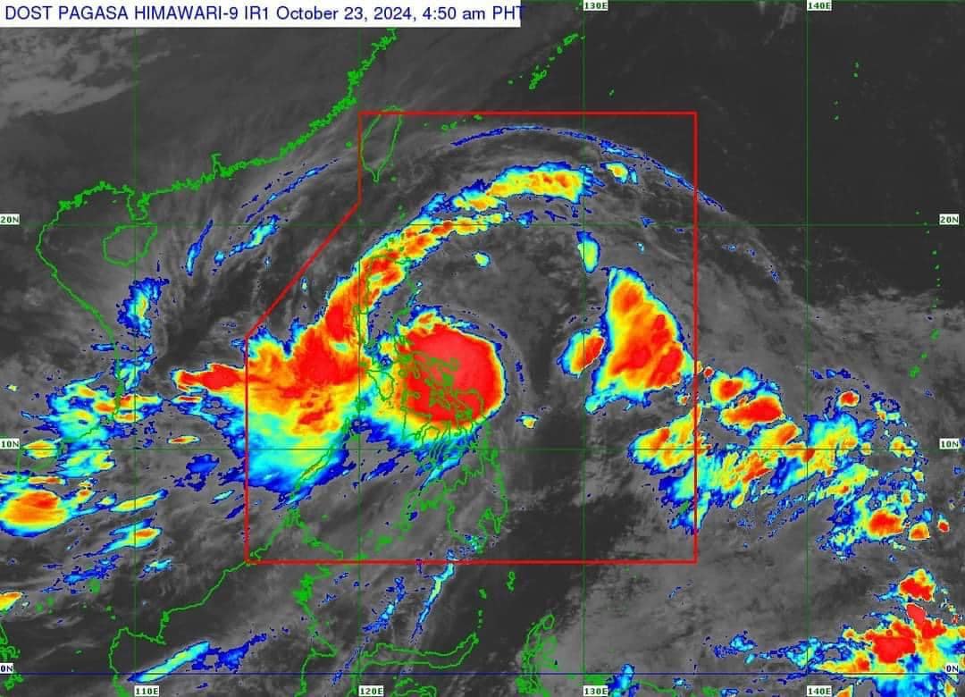
Signal No. 2 has been hoisted over 27 areas in Luzon and the Visayas as #KristinePH intensifies slightly over the sea east of Quezon, according to PAGASA update issued at 5 a.m. on Wednesday, October 23, 2024.
These areas include the following:
Luzon
- Ilocos Norte
- Ilocos Sur
- La Union
- Pangasinan
- Apayao
- Abra
- Kalinga
- Mountain Province
- Ifugao
- Benguet
- mainland Cagayan
- Isabela
- Quirino
- Nueva Vizcaya
- Aurora
- Nueva Ecija
- Tarlac
- the northern portion of Zambales (Santa Cruz, Candelaria, Masinloc, Palauig)
- the northern portion of Bulacan (Doña Remedios Trinidad, San Miguel, San Ildefonso),
- the northern portion of Quezon (General Nakar, Infanta) including Polillo Islands,
- Camarines Norte
- the northern and eastern portions of Camarines Sur (Calabanga, Goa, Tigaon, Saglay, San Jose, Lagonoy, Tinambac, Siruma, Garchitorena, Presentacion, Caramoan),
- Catanduanes
- the eastern portion of Albay (Rapu-Rapu, Bacacay, City of Tabaco, Malilipot, Malinao, Tiwi, Manito, Santo Domingo)
- the eastern portion of Sorsogon (Barcelona, Gubat, Prieto Diaz, City of Sorsogon)
Visayas
- the northeastern portion of Northern Samar (Palapag, Mapanas, Gamay, Laoang, Catubig, Lapinig, Pambujan, San Roque)
- the northern portion of Eastern Samar (Jipapad, San Policarpo, Arteche)
Meanwhile, the following areas are under Signal No. 1:
Luzon
- Batanes
- Babuyan Islands
- Pampanga
- the rest of Zambales
- Bataan
- the rest of Bulacan
- Metro Manila
- Rizal
- Cavite
- Laguna
- Batangas
- the rest of Quezon
- Occidental Mindoro including Lubang Islands
- Oriental Mindoro
- Marinduque
- Romblon
- Calamian Islands
- the rest of Camarines Sur
- the rest of Albay
- the rest of Sorsogon
- Masbate including Ticao and Burias Islands
- Calamian Islands
Visayas
- Aklan
- Capiz
- Antique including Caluya Islands,
- Iloilo
- Guinaras
- the northern portion of Negros Occidental (Pontevedra, La Castellana, Moises Padilla, Bago City, La Carlota City, Valladolid, Pulupandan, Bacolod City, San Enrique, Murcia, Silay City, City of Talisay, Enrique B. Magalona, Manapla, City of Victorias, Cadiz City, Sagay City, City of Escalante, Toboso, Calatrava, Salvador Benedicto, San Carlos City)
- the northern portion of Negros Oriental (Vallehermoso, Canlaon City, City of Guihulngan)
- the northern and central portions of Cebu (Alcantara, Argao, Dumanjug, Sibonga, Pinamungahan, Ronda, Liloan, Cebu City, Moalboal, Consolacion, Danao City, Borbon, Carmen, Daanbantayan, Tuburan, City of Bogo, Tabogon, City of Naga, Lapu-Lapu City, City of Carcar, Mandaue City, Catmon, Minglanilla, Toledo City, Cordova, Compostela, San Remigio, Balamban, Aloguinsan, San Fernando, Asturias, Barili, Medellin, Sogod, Tabuelan, City of Talisay) including Bantayan Islands and Camotes Islands
- Bohol
- the rest of Eastern Samar
- the rest of Northern Samar
- Samar
- Leyte
- Biliran
- Southern Leyte
Mindanao
- Dinagat Islands
- Surigao del Norte including Siargao - Bucas Grande Group
TRACK AND INTENSITY OUTLOOK
Kristine is forecast to move generally northwestward for the next 24 hours before turning generally westward for the rest of the forecast period, PAGASA said.
It is expected to make landfall over Isabela or northern Aurora evening on Wednesday, October 23, or early morning on Thursday, October 24.
It will then cross the mountainous terrain of Northern Luzon and emerge over the waters west of Ilocos Region Thursday afternoon and may exit the Philippine Area of Responsibility (PAR) region on Friday.
The tropical storm is forecast to intensify gradually into a severe tropical storm before making landfall. Slight weakening will occur while crossing Northern Luzon and re-intensification may occur over the West Philippine Sea, according to PAGASA.