


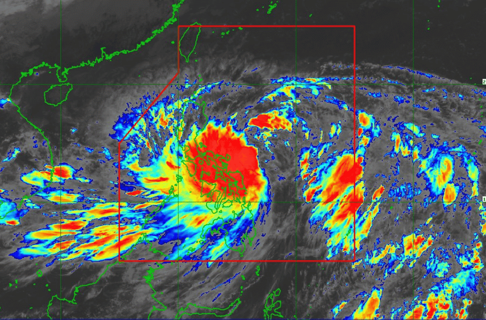
#KristinePH has intensified into a Tropical Storm as it continues to move west northwestward over the Philippine Sea, according to the Philippine Atmospheric, Geophysical and Astronomical Services Administration (PAGASA).
As of 11:00 a.m. on October 22, 2024, the center of "Kristine" was located 335 km east of Virac, Catanduanes.
The storm is moving at a speed of 10 km/h in a west northwestward direction.
"Kristine" currently has maximum sustained winds of 65 km/h near its center, with gustiness reaching up to 80 km/h.
Tropical Cyclone Wind Signal No. 2 has been raised over:
- Catanduanes
Tropical Cyclone Wind Signal No. 1 has been raised over:
Luzon:
- Ilocos Norte
- Ilocos Sur
- La Union
- Pangasinan
- Apayao
- Kalinga
- Abra
- Mountain Province
- Ifugao
- Benguet
- Cagayan, including Babuyan Islands
- Isabela
- Quirino
- Nueva Vizcaya
- Aurora
- Nueva Ecija
- Tarlac
- Zambales
- Bataan
- Pampanga
- Bulacan
- Metro Manila
- Cavite
- Laguna
- Batangas
- Rizal
- Quezon, including Polillo Islands
- Masbate, including Ticao Island, Burias Island
- Marinduque
- Romblon
- Camarines Norte
- Camarines Sur
- Albay
- Sorsogon
Visayas:
- Eastern Samar
- Northern Samar
- Samar
- Leyte
- Biliran
- Southern Leyte
Mindanao:
- Dinagat Islands
- Surigao del Norte, including Siargao - Bucas Grande Group
Heavy Rainfall Outlook:
Refer to Weather Advisory No. 7 issued at 11:00 a.m. today for the heavy rainfall outlook due to "Kristine."
Severe Winds:
The wind signals warn the public of the general wind threat over an area due to the tropical cyclone. Local winds may be slightly stronger or enhanced in coastal and upland/mountainous areas exposed to winds. Minor to moderate impacts from gale-force winds are possible within any of the localities where Wind Signal No. 2 is hoisted. Minimal to minor impacts from strong winds are possible within any of the areas under Wind Signal No. 1.
The highest wind signal which may be hoisted during the occurrence of "Kristine" is still Wind Signal No. 3, considering the possibility of rapid intensification. Furthermore, the wind flow coming towards the circulation of "Kristine" and the northeasterly wind flow will also bring strong to gale-force gusts over the following areas, especially in coastal and upland areas exposed to winds:
- Today (October 22): Batanes, Babuyan Islands, Ilocos Region, Palawan, Romblon, Aklan, Antique, Negros Island Region, Central Visayas, Southern Leyte, Zamboanga del Norte, Northern Mindanao, Dinagat Islands, Surigao del Norte, Agusan del Norte, Sarangani, Davao del Sur, and Davao Oriental.
- Tomorrow (October 23): MIMAROPA, Visayas, and Mindanao.
- Thursday (October 24): MIMAROPA, Bicol Region, Visayas, Basilan, Sulu, Tawi-Tawi, Zamboanga del Norte, Lanao del Sur, Northern Mindanao, Dinagat Islands, Surigao del Norte, Davao del Sur, and Davao Oriental.
Coastal Inundation:
There is a moderate to high risk of life-threatening storm surge in the next 48 hours over the low-lying or exposed coastal localities of Catanduanes, Camarines Sur, Albay, Aurora, Isabela, and Cagayan. For more information, refer to Storm Surge Warning No. 1 issued at 8:00 a.m. today.
Hazards Affecting Coastal Waters:
A Gale Warning is hoisted over the eastern seaboard of Luzon, the southern seaboard of Southern Luzon, and the eastern seaboard of Visayas. For more information, refer to Gale Warning No. 3A issued at 11:00 a.m. today.
24-Hour Sea Condition Outlook:
- Up to high seas over the following coastal waters:
- Up to 7.0 m: The seaboard of Batanes, Cagayan including Babuyan Islands, Isabela, Catanduanes, Camarines Norte, and the northern and eastern seaboards of Camarines Sur.
- Up to 6.0 m: The seaboard of northern Aurora, Polillo Islands, and Ilocos Norte.
Sea travel is risky for all types or tonnage of vessels. All mariners must remain in port or, if underway, seek shelter or safe harbor as soon as possible until winds and waves subside.
- Up to very rough seas over the following coastal waters:
- Up to 5.0 m: The remaining seaboard of the Ilocos Region, the eastern seaboard of Albay, the eastern seaboard of Sorsogon, and the northern and eastern seaboards of Northern Samar.
Mariners of small seacrafts, including all types of motorbancas, are advised not to venture out to sea under these conditions, especially if inexperienced or operating ill-equipped vessels.
- Up to moderate seas over the following coastal waters:
- Up to 2.5 m: The remaining seaboards of the country.
Mariners of motorbancas and similarly-sized vessels are advised to take precautionary measures while venturing out to sea and, if possible, avoid navigation under these conditions.
Track and Intensity Outlook:
"Kristine" is forecast to move generally northwestward until it makes landfall over Isabela or northern Aurora tomorrow (October 23) evening or on Thursday (October 24) early morning. It will then cross the mountainous terrain of Northern Luzon and emerge over the waters west of Ilocos Region on Thursday afternoon or evening. Changes in forecast track are not ruled out, depending on the movement of the weather systems surrounding this tropical cyclone in the next few days.
"Kristine" is forecast to gradually intensify into a severe tropical storm before making landfall. Slight weakening will occur while crossing Northern Luzon. Over the West Philippine Sea, "Kristine" may reach typhoon category before exiting the Philippine Area of Responsibility (PAR) region on Friday (October 25).
