

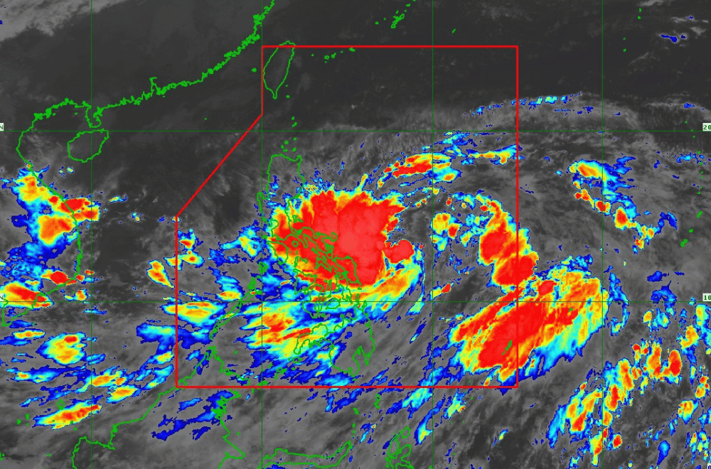
Tropical Depression #KristinePH has maintained its strength while accelerating westward, according to the Philippine Atmospheric, Geophysical and Astronomical Services Administration (PAGASA).
As of 11:00 p.m. on October 21, 2024, the center of #KristinePH was located 480 km east of Catarman, Northern Samar.
The storm is moving at a speed of 25 km/h in a westward direction.
The storm currently has maximum sustained winds of 55 km/h near its center, with gustiness reaching up to 70 km/h.
Tropical Cyclone Wind Signal No. 1 has been raised over:
Luzon
- The eastern portion of Isabela (Palanan, Dinapigue, Maconacon, Divilacan, San Mariano, Ilagan City, San Guillermo, Echague, Jones, San Agustin, City of Cauayan, Benito Soliven, Angadanan, Naguilian)
- The southeastern portion of Quirino (Maddela, Nagtipunan)
- The southern portion of Nueva Vizcaya (Alfonso Castaneda)
- Aurora
- The northern and eastern portions of Quezon (Tagkawayan, Guinayangan, Buenavista, San Narciso, San Andres, General Nakar, Pitogo, San Francisco, Calauag, Pagbilao, Infanta, Lopez, Catanauan, Mulanay, Unisan, General Luna, Plaridel, Quezon, Alabat, Sampaloc, Padre Burgos, Macalelon, Mauban, Perez, Agdangan, Gumaca, Atimonan, Real) including Polillo Islands
- Marinduque
- Camarines Norte
- Camarines Sur
- Catanduanes
- Albay
- Sorsogon
- Masbate including Ticao Island and Burias Island
Visayas
- Eastern Samar
- Northern Samar
- Samar
- Leyte
- Biliran
- Southern Leyte
Mindanao
- Dinagat Islands
- Surigao del Norte, including Siargao - Bucas Grande Group
Heavy Rainfall Outlook:
PAGASA has warned of potential heavy rainfall from #KristinePH. Areas such as Northern Samar, Eastern Samar, and the Bicol Region may experience significant rainfall over the next 24 hours, leading to possible flooding and landslides in mountainous regions.
Severe Winds:
Minimal to minor impacts from strong winds are expected in areas under Wind Signal No. 1. Local winds may be slightly stronger in coastal and upland areas exposed to wind. Gale-force gusts are possible in these areas, especially over the regions of Batanes, Babuyan Islands, Ilocos Region, and parts of Visayas and Mindanao tomorrow (October 22).
Hazards Affecting Coastal Waters:
A Gale Warning is in effect for the eastern seaboards of Southern Luzon and Visayas, with sea travel deemed risky. Mariners are advised to avoid navigating in these conditions.
Track and Intensity Outlook:
#KristinePH is forecast to continue its northwestward movement until Wednesday (October 23) evening before turning westward. It is expected to intensify into a tropical storm within the next 12 hours and may make landfall over Northern Luzon as a severe tropical storm by Thursday (October 24) morning. The storm could further intensify into a typhoon as it moves over the West Philippine Sea.
PAGASA advises the public to stay updated on further advisories and take necessary precautions as #KristinePH progresses.
