

Super Typhoon #JulianPH has slightly intensified while moving westward and is currently outside the Philippine Area of Responsibility (PAR), according to the latest advisory from the Philippine Atmospheric, Geophysical and Astronomical Services Administration (PAGASA).
However, it may re-enter PAR by Wednesday, October 2, 2024.
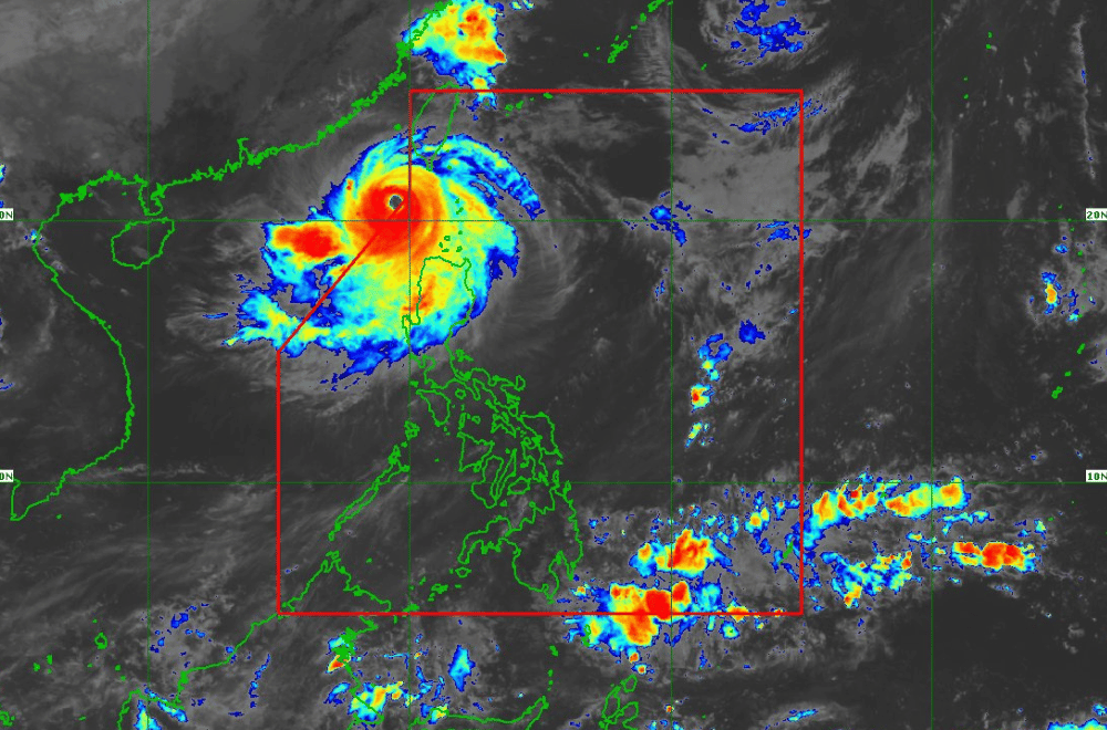
As of 11:00 a.m. of October 1, the center of #JulianPH was located 235 km west of Itbayat, Batanes.
The storm is moving westward.
Currently, #JulianPH has maximum sustained winds of 195 km/h near its center, with gustiness reaching up to 240 km/h.
Tropical Cyclone Wind Signal No. 2 has been raised over:
- Batanes
- Babuyan Islands
- Northern portions of Ilocos Norte (Bacarra, Pasuquin, Bangui, Vintar, Burgos, Pagudpud, Dumalneg, Adams)
- Northwestern portions of mainland Cagayan (Santa Praxedes, Claveria, Sanchez-Mira)
Tropical Cyclone Wind Signal No. 1 has been raised over:
- The rest of Ilocos Norte
- Ilocos Sur
- La Union
- Pangasinan
- Apayao
- Kalinga
- Abra
- Mountain Province
- Ifugao
- Benguet
- The rest of mainland Cagayan
- Isabela
- Quirino
- Nueva Vizcaya
- Northern portions of Aurora (Dilasag, Casiguran, Dinalungan)
- Northern portions of Nueva Ecija (Carranglan, Lupao, Pantabangan)
Heavy Rainfall Outlook:
PAGASA advises the public to refer to Weather Advisory No. 23 issued at 11:00 AM today for the heavy rainfall outlook. Coastal and upland areas may experience strong winds, with minimal to moderate impacts expected under TCWS No. 2 and minor impacts under TCWS No. 1.
Severe Winds:
Strong to gale-force gusts may affect regions such as the Ilocos Region, Cordillera Administrative Region, Cagayan, Isabela, Aurora, Zambales, Bataan, Metro Manila, CALABARZON, Romblon, and Camarines Norte today. Tomorrow, similar conditions will affect Ilocos Norte, Ilocos Sur, Abra, Apayao, Batanes, Babuyan Islands, and parts of mainland Cagayan and Isabela.
Coastal Inundation:
A moderate to high risk of storm surge is expected over Batanes and Babuyan Islands in the next 48 hours. Residents in coastal areas are urged to take precautions and follow updates from Storm Surge Warning No. 8.
Hazards Affecting Coastal Waters:
Gale warnings are in place over the northern and western seaboards of Northern Luzon. High seas, reaching up to 7.0 meters, are expected in Batanes, while very rough seas of up to 6.0 meters will affect the Babuyan Islands and Ilocos Norte. Mariners are advised to avoid sea travel, especially small vessels.
Track and Intensity Outlook:
Super Typhoon #JulianPH is forecast to recurve towards the sea southwest of Taiwan today and may make landfall in Taiwan by tomorrow morning or afternoon. The typhoon is expected to weaken into a severe tropical storm as it crosses Taiwan and enters the East China Sea by Thursday.
PAGASA advises the public to stay updated on further advisories and remain cautious as #JulianPH progresses.
