

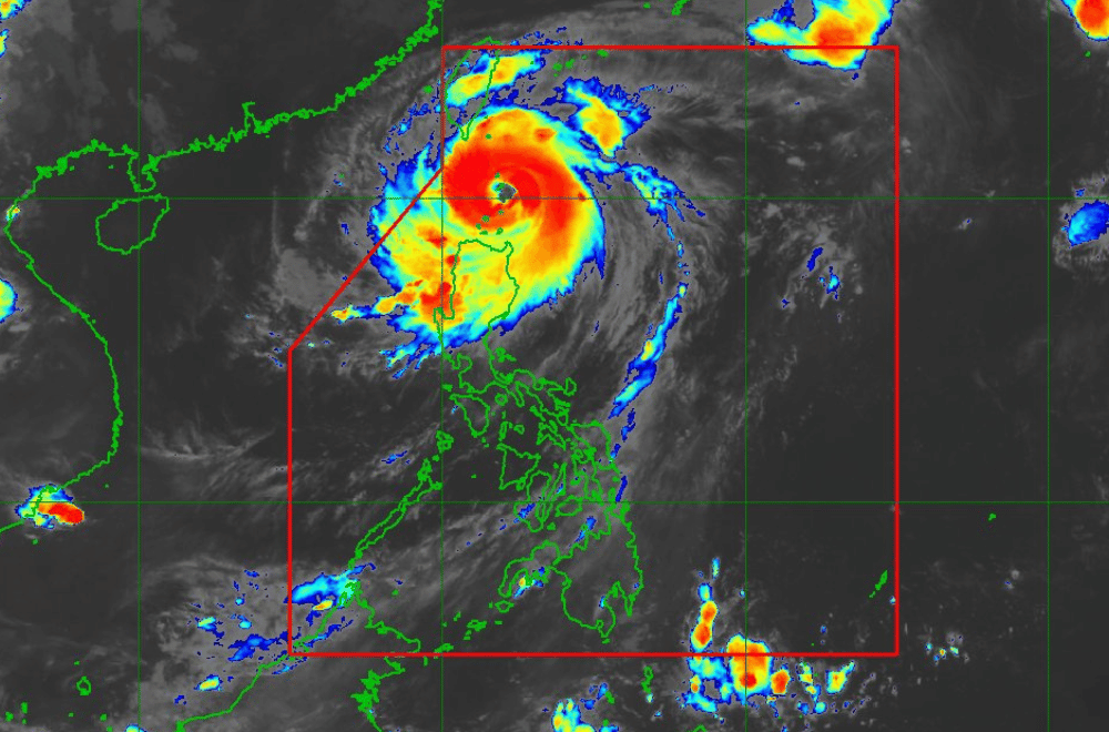
Typhoon #JulianPH has further intensified and is approaching Super Typhoon category as it moves over the Balintang Channel, according to the Philippine Atmospheric, Geophysical and Astronomical Services Administration (PAGASA).
As of 8:00 a.m. on September 30, 2024, the center of "Julian" was located near Balintang Island, Calayan, Cagayan.
The storm is moving at a speed of 10 km/h in a west-northwestward direction.
It currently has maximum sustained winds of 175 km/h near its center, with gustiness reaching up to 215 km/h.
Tropical Cyclone Wind Signal No. 4 has been raised over:
- Batanes
- Northern portion of Babuyan Islands (Babuyan Island, Calayan Island)
Tropical Cyclone Wind Signal No. 3 has been raised over:
- The rest of Babuyan Islands
- Northeastern portion of mainland Cagayan (Santa Ana)
Tropical Cyclone Wind Signal No. 2 has been raised over:
- The rest of mainland Cagayan
- Apayao
- Northern portion of Abra (Tineg, Lacub, Malibcong, Licuan-Baay, San Juan, Lagayan, Lagangilang, Dolores, Daguioman, Danglas, La Paz)
- Northern portion of Kalinga (Pinukpuk, Balbalan, City of Tabuk, Rizal)
- Ilocos Norte
- Northern portion of Ilocos Sur (Sinait, Cabugao)
Tropical Cyclone Wind Signal No. 1 has been raised over:
- The rest of Ilocos Sur, La Union, Pangasinan
- The rest of Abra, Kalinga, Ifugao, Mountain Province, Benguet
- Isabela, Nueva Vizcaya, Quirino
- Aurora, Polillo Islands
- Northern and eastern portions of Nueva Ecija (Cuyapo, Rizal, Laur, Pantabangan, Science City of Muñoz, Gabaldon, Carranglan, San Jose City, Lupao, Talugtug, Bongabon, Llanera, Talavera, Palayan City, General Mamerto Natividad)
Heavy Rainfall Outlook:
Refer to Weather Advisory No. 17 issued at 8:00 AM for the heavy rainfall outlook associated with Typhoon "Julian."
Severe Winds:
The peak of devastating typhoon-force winds is expected in areas under TCWS No. 4 from this morning until the afternoon. PAGASA has warned that the possibility of raising Wind Signal No. 5 remains.
Winds will be slightly stronger in coastal and upland areas, with significant to severe impacts from typhoon-force winds in areas under Signal No. 4. Moderate to significant impacts are expected under Signal No. 3, while areas under Signal No. 2 may experience moderate to minimal impacts from gale-force winds.
Additionally, strong to gale-force gusts are possible in the following regions today (30 September): Pangasinan, Aurora, Zambales, Bataan, Metro Manila, CALABARZON, Romblon, and the Bicol Region. Similar conditions are expected tomorrow (1 October) over Ilocos Region, Cordillera Administrative Region, northern and eastern portions of Cagayan, eastern Isabela, and parts of Visayas and MIMAROPA.
Coastal Inundation:
Moderate to high risk of life-threatening storm surge is expected over the low-lying areas of Batanes, Cagayan, and Ilocos Norte within the next 48 hours.
Hazards Affecting Coastal Waters:
A Gale Warning remains in effect for the seaboards of Northern Luzon. PAGASA has issued warnings for seas as high as 14.0 meters over Batanes' seaboards, up to 10.0 meters around Babuyan Islands, and up to 6.0 meters along the northern coasts of Ilocos Norte.
Mariners are advised to remain in port or seek safe harbor until conditions subside. Sea travel remains dangerous for most types of vessels across the region.
Track and Intensity Outlook:
Typhoon "Julian" is expected to move west-northwestward over the Balintang Channel, passing close to Balintang Island and Batanes this morning through the afternoon. Landfall remains possible over these areas.
By 1 October, "Julian" will likely begin to recurve northeastward toward Taiwan, potentially leaving the Philippine Area of Responsibility briefly. The typhoon will weaken after interacting with Taiwan's rugged terrain but may still reach super typhoon status before landfall.
PAGASA advises the public to monitor updates and take necessary precautions.
