

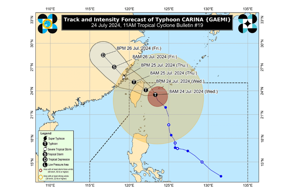
As of 11 a.m. on July 24, 2024, Typhoon Carina has intensified further, now reaching winds of up to 165 km/h as it heads toward Taiwan, according to the Department of Science and Technology - Philippine Atmospheric, Geophysical and Astronomical Services Administration (DOST-PAGASA).
Typhoon Carina, currently 345 km north-northeast of Itbayat, Batanes, is moving north-northwest at 15 km/h. The storm has strengthened, with maximum sustained winds of 165 km/h and gusts reaching 205 km/h.
It is expected to make landfall over northern Taiwan this evening of July 24 or early morning of July 25.
After crossing Taiwan, the typhoon will exit the Philippine Area of Responsibility (PAR) and make its final landfall in southeastern China on the afternoon or evening of July 25.
Carina may intensify further before landfall and could reach Super Typhoon status.
TROPICAL CYCLONE WIND SIGNALS (TCWS)
TCWS No. 2: Batanes. Expect winds over 62 km/h, with possible minor to moderate impacts.
TCWS No. 1: Babuyan Islands, northern Cagayan, and northern Ilocos Norte. Minimal to minor impacts from strong winds are anticipated.
Some parts of Luzon also announced class and work suspensions on July 24, due to bad weather from the Southwest Monsoon, which has been intensified by Typhoon "Carina."
RAINFALL FORECAST
From July 24 until July 25, areas in Batanes and Babuyan Islands are forecasted to recieve 50-100 mm of rain.
The Southwest Monsoon, enhanced by Carina, will bring moderate to intense rainfall to western Luzon through July 26.
GALE WARNING
A gale warning is issued for Batanes, Babuyan Islands, and northern Cagayan. Sea travel is risky, especially for small vessels. Rough seas, ranging from 2.5 to 4.0 meters, are expected over northern and western Luzon coasts.
PAGASA advised residents in areas under TCWS No. 2 to prepare for power outages, secure fishing boats, and elevate household items to prevent flood damage.
Residents are urged to monitor the latest Severe Weather Bulletin from PAGASA every six hours and stay updated with hourly forecasts.
