

ADVERTISEMENT
Filtered By: Topstories
News
Flooding along major waterways can be alleviated by relocating informal settlers
In a recent briefing at Malacañang, Department of Public Works and Highways Secretary Rogelio Singson emphasized the need to clear informal settlers from eight major waterways in Metro Manila. Around 20,000 informal settler families will have to be relocated to rid the waterways of any obstruction during heavy rains, he said.
The 20,000 families themselves are living in danger zones. But their presence also puts more than 2.2 million residents—at least 19 percent of the Metro Manila population—at risk for flooding.
The eight priority waterways identified by the DPWH are San Juan River, Pasig River, Tullahan River, Maricaban Creek, Manggahan Floodway, Estero Tripa de Gallina, Estero de Maypajo, and Estero de Sunog Apog.
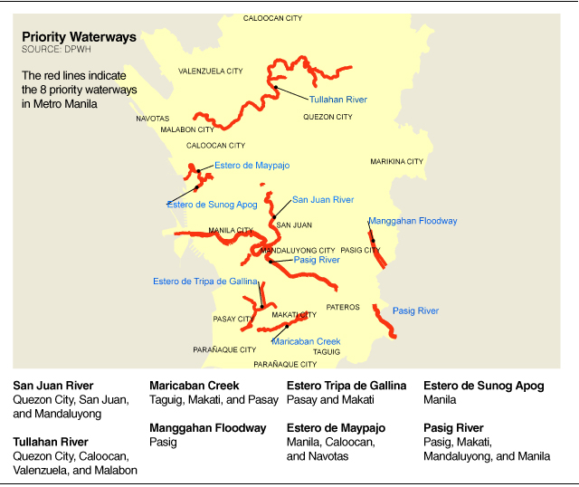
These waterways traverse 12 of the 17 local government units in the National Capital Region.
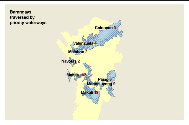
Using the Geographic Information System, GMA News Research identified 211 barangays lying along these critical waterways. The total residential population of these barangays is 2,241,635 as of the 2010 census.
| Population of Barangays along Critical Waterways (2010) | 2,241,635 |
| Population in Metro Manila | 11,855,975 |
| Percentage | 18.91% |
“The residents in these areas are also at risk. We have seen this happen in previous big floodings like Ondoy and just last year’s monsoon rains,” says University of the Philippines Department of Geography Professor Meliton Juanico.
Juanico agrees that these particular waterways should be prioritized, noting that they are much more vulnerable compared to the others because they lie along highly populated areas.
Manila has the most number of barangays along critical highways (107) because these are traversed by four priority waterways: Pasig River, San Juan River, Estero de Maypajo, and Estero de Sunog Apog. But Quezon City has the most number of residents living along priority waterways: 544,294 in barangays along San Juan River and Tullahan River.
Pasig City has eight barangays lying along Manggahan Floodway and the Pasig River, with a population of 358,675.
| CITY
| NUMBER OF BARANGAYS ALONG PRIORITY WATERWAYS | POPULATION OF BARANGAYS INTERSECTED BY PRIORITY WATERWAYS |
| Quezon City | 16 | 544,294 |
| Pasig | 8 | 358,675 |
| Manila | 107 | 323,201 |
| Makati | 19 | 310,081 |
| Valenzuela | 4 | 200,051 |
| Caloocan | 9 | 104,745 |
| Pasay | 26 | 102,029 |
| Taguig | 2 | 86,280 |
| Navotas | 2 | 71,905 |
| Mandaluyong | 9 | 71,201 |
| San Juan | 7 | 39,466 |
| Malabon | 2 | 29,707 |
| TOTAL | 211 | 2,241,635 |
| Sources: GMA News Research and NSO | ||
Among the 211 high-risk barangays are four of the biggest in terms of population in Metro Manila. Barangay Pinagbuhatan in Pasig City ranks fourth in terms of population, with 126,503 residents, and is traversed by the Pasig River. Barangay Hen. T. De Leon in Valenzuela City, the ninth most populous in Metro Manila, is along Tullahan River.
Tullahan River also crosses Quezon City’s Barangay Sauyo, which ranks number 18 in terms of population. A portion of Western Bicutan in Taguig City is along Maricaban Creek. Western Bicutan is 19th most populous barangay in Metro Manila.
During the colossal Ondoy floods of September 2009, two were killed in Sauyo after contracting leptospirosis. Six people in Pinagbuhatan became infected with leptospirosis.
| CITY | BARANGAY | 2010 POPULATION | WATERWAY |
| Pasig | Pinagbuhatan | 126,503 | Pasig River |
| Valenzuela | Hen. T. De Leon | 89,209 | Tullahan River |
| Quezon City | Sauyo | 74,740 | Tullahan River |
| Taguig | Western Bicutan | 72,926 | Maricaban Creek |
| Sources: GMA News Research and NSO | |||
Professor Juanico points out that under the Water Code, there should be a buffer along the riverbanks to ensure the flow of water during rains. “Our Water Code requires a 3-meter clearance between riverbanks and residential areas. But space seems to be scarce, not to mention expensive, in urban areas like Metro Manila,” he says.
Those who cannot afford expensive housing build their homes along the banks of rivers and tributaries. Of the critical waterways, San Juan River—traversing Quezon City, San Juan City, and Manila—has the biggest number of informal settlers for relocation, with 4,217 families. Second is Estero Tripa de Gallina in Pasay City and Makati City, with 3,887 families.
Tullahan River passes Quezon City, Caloocan City, Valenzuela City, and Malabon City and has a total of 3,683 informal settler families.
Tullahan River is the natural drainage of La Mesa Dam in Quezon City. According to the Philippine Atmospheric, Geophysical and Astronomical Services Administration, the Quezon City barangays of Fairview, Forest Hill, Quirino Hi-way, Capri, Goodwill, Sta. Quiteria and San Bartolome might be affected every time the dam reaches spilling level. Barangays in Valenzuela and Malabon are also located along the spillway of the La Mesa Dam.
The Manggahan Floodway in Pasig City is home to 2,997 informal settlers. It was built to prevent floods by controlling excess water from Marikina River during heavy rains. This is done by either closing the floodway gates or by diverting water to Laguna de Bay, when the lake’s water level is not high.
Maricaban Creek crosses the cities of Pasay, Makati, and Taguig and has 1,637 families settled along its bank. Pasig River passes four cities—Pasig, Makati, Mandaluyong, and Manila—and has 1,434 settlers. Estero de Maypajo in the cities of Manila, Caloocan, and Navotas has 1,415 families. Some 170 families inhabit the stretch of Estero de Sunog Apog in Manila.
“Why is it so hard to relocate these informal settlers? It all boils down to political will. We might have very good environmental plans but the problem is implementation,” Juanico says.
Juanico says the flood problem in Metro Manila requires a multi-dimensional solution and should include those areas in the Laguna Lake watershed. —Ronin Bautista/VC, GMA News
