Pepito intensifies as PAGASA warns of 'potentially catastrophic situation' in Bicol

Signal No. 5 has been raised over Catanduanes as Super Typhoon Pepito further intensified, PAGASA said Saturday.
In its 2 p.m. weather bulletin, the state weather bureau said Pepito poses "a potentially catastrophic and life-threatening situation for the Northeastern Bicol Region."
PAGASA has raised the following storm signals in the following areas:
Signal No. 5
- Catanduanes
Signal No. 4
- The northeastern portion of Camarines Sur (Garchitorena, Caramoan, Presentacion, Siruma, Tinambac, Goa, Lagonoy, San Jose, Tigaon, Sagñay)
- the northeastern portion of Albay (City of Tabaco, Tiwi, Malinao, Malilipot, Bacacay, Rapu-Rapu)
Signal No. 3
Luzon
- Polillo Islands, the southeastern portion of mainland Quezon (Calauag, Guinayangan, Tagkawayan, Buenavista)
- Camarines Norte
- The rest of Camarines Sur
- The rest of Albay
- The northern portion of Sorsogon (Prieto Diaz, City of Sorsogon, Gubat, Barcelona, Castilla, Casiguran, Pilar, Donsol)
Visayas
- The eastern and central portions of Northern Samar (Palapag, Laoang, Mapanas, Gamay, Lapinig, Catubig, Pambujan, Las Navas, Biri, Bobon, Catarman, Mondragon, San Roque, Silvino Lobos, Lope de Vega, San Jose)
- The northern portion of Eastern Samar (San Policarpo, Arteche, Oras, Jipapad)
Signal No. 2
Luzon
- The southern portion of Isabela (Dinapigue, Cordon, Ramon, Alicia, City of Cauayan, Angadanan, City of Santiago, San Isidro, Echague, Jones, San Agustin, San Guillermo, San Mariano, Benito Soliven, Naguilian, Palanan)
- Quirino
- Nueva Vizcaya
- The eastern portion of Pangasinan (San Nicolas, Umingan, Natividad, San Quintin, Tayug, Santa Maria, Rosales, Balungao, San Manuel, Villasis, Malasiqui, Bautista, Mapandan, Binalonan, Alcala, Asingan, Santo Tomas, City of Urdaneta, Laoac, Manaoag, Bayambang, Santa Barbara)
- Aurora
- Nueva Ecija
- Bulacan
- Tarlac
- Pampanga
- The southern portion of Zambales (Botolan, Cabangan, San Marcelino, San Felipe, San Narciso, San Antonio, Castillejos, Subic, Olongapo City)
- Bataan
- Metro Manila
- Rizal
- The rest of Quezon
- Laguna
- Cavite
- Marinduque
- Burias Island
- Ticao Island
Visayas
- The central portion of Eastern Samar (Dolores, Maslog, Can-Avid, Taft, Sulat, San Julian, City of Borongan)
- The northern portion of Samar (Matuguinao, Calbayog City, Santa Margarita, San Jorge, San Jose de Buan, Tarangnan, Motiong, Gandara, Jiabong, City of Catbalogan, Paranas, Hinabangan, San Sebastian, Pagsanghan)
- The rest of Northern Samar
Signal No. 1
Luzon
- Mainland Cagayan
- The rest of Isabela
- Apayao
- Kalinga
- Abra
- Mountain Province
- Ifugao
- Benguet
- Ilocos Norte
- Ilocos Sur
- La Union
- The rest of Pangasinan
- The rest of Zambales
- Batangas
- The northern portion of Occidental Mindoro (Sablayan, Santa Cruz, Mamburao, Abra de Ilog, Paluan) including Lubang Islands, the northern portion of Oriental Mindoro (Puerto Galera, San Teodoro, Naujan, Baco, Victoria, Socorro, Pinamalayan, Bansud, Gloria, Pola, City of Calapan, Bongabong, Roxas, Mansalay)
- Romblon
- The rest of Masbate
Visayas
- The rest of Eastern Samar
- The rest of Samar, Biliran
- The northern and central portions of Leyte (Tunga, Pastrana, San Miguel, Matag-Ob, Tolosa, Palo, Calubian, Leyte, Mayorga, Julita, Carigara, Babatngon, Dagami, Jaro, San Isidro, Santa Fe, Albuera, Villaba, La Paz, Palompon, Macarthur, Tabontabon, Tanauan, Merida, Ormoc City, Isabel, Dulag, Capoocan, Alangalang, Burauen, Tabango, Tacloban City, Kananga, Barugo, Abuyog, Javier, City of Baybay, Mahaplag)
- The northeastern portion of Southern Leyte (Silago)
- The northernmost portion of Cebu (Daanbantayan, Medellin) including Bantayan Islands
- The northernmost portion of Iloilo (Carles)
Mindanao
- The northern portion of Dinagat Islands (Loreto, Tubajon)

Strength
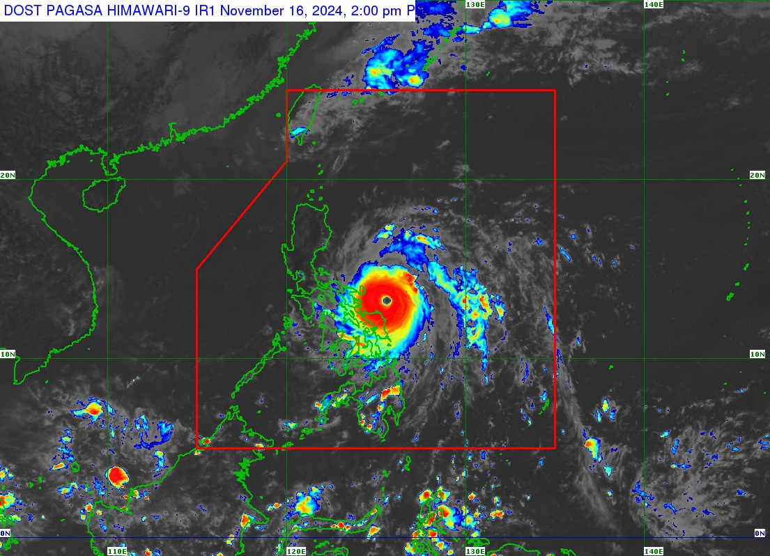
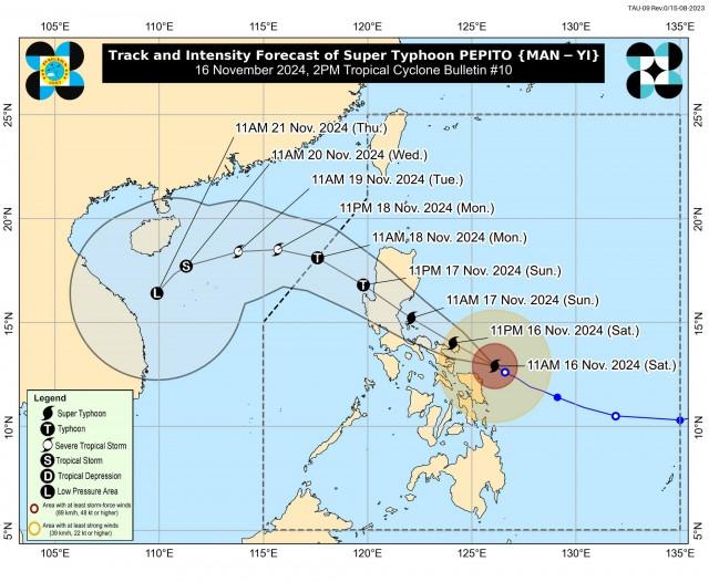
As of 1 p.m., the center of the eye of Super Typhoon Pepito was last spotted 200 km East of Juban, Sorsogon or 180 km East Southeast of Virac, Catanduanes (13.1 °N, 125.8°E).
It has maximum sustained winds of 195 km/h near the center, gustiness of up to 240 km/h, and central pressure of 920 hPa, and it is moving West northwestward at 20 km/h.
PAGASA said Strong to typhoon-force winds extend outwards up to 300 km from the center.
Storm surge
PAGASA warned that there is a high risk of a life-threatening storm surge with peak heights exceeding 3.0 m in the next 48 hours over the low-lying or exposed coastal localities of Ilocos Region (western coast), Isabela, Central Luzon, Metro Manila, CALABARZON, Marinduque, Bicol Region, Northern Samar, Samar, Eastern Samar, and Biliran.
A Gale Warning is also hoisted over the eastern and southern seaboards of Southern Luzon and the eastern seabooad of Visayas.
Forecast track
Based on the forecast track, Pepito will move generally west northwestward within the next three days before turning generally westward to west southwestward from Monday (18 November) afternoon to Thursday (21 November) early morning.
“On the track forecast, Pepito is more likely to make landfall in the vicinity of Catanduanes tonight or tomorrow (17 November) early morning,” PAGASA said.
“However, considering the limits of the forecast confidence cone, a landfall scenario over the eastern coast of Camarines Sur or Albay during the same time frame (if it moves slightly south of forecast track), or along the eastern coast of Quezon or Aurora tomorrow afternoon or evening remains (if it moves slightly north of forecast track) not ruled out. PEPITO is expected to exit the Philippine Area of Responsibility (PAR) on Monday,” it added.
Moreover, it noted that Pepito is approaching its peak intensity, and may begin to maintain or slightly decrease in the next coming hours.
—VAL, GMA Integrated News


