

China reclaimed 3,000 hectares in SCS including WPS features —PH Navy
The Philippine Navy on Tuesday said that China has reclaimed around 3,000 hectares in the South China Sea (SCS) including some features in the West Philippine Sea.
In a press conference, Philippine Navy spokesperson for WPS Rear Admiral Roy Vincent Trinidad said “the total reclaimed area within our exclusive economic zone (EEZ) and out of our EEZ, roughly around 3,000 hectares. This includes [China’s] major bases.”
“This includes Subi Reef, which I would like to correct is outside our EEZ, although it is roughly 12 to 15 nautical miles from Pag-asa,” he added.
READ: Chinese structures, military equipment monitored in Subi Reef in WPS
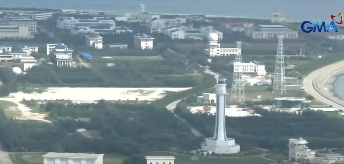
According to Trinidad, China’s major bases in Subi or Zamora Reef, Mischief or Panganiban Reef, and Johnson or Mabina-Roxas Reef are already “militarized.”
“They have airstrips. They have harbors for warships. There are structures on land that we could only surmise are aircraft hangars. They have military-grade communications equipment,” he added.
According to Trinidad, Mischief Reef and Johnson Reef are within the Philippine EEZ.
Since 2013, Trinidad said that there has been no new and massive reclamation in the SCS but there were some recent improvements of China’s facilities.
“On the details of that I could not, I have no knowledge of that. But we monitored the presence of construction vehicles, heavy equipment vehicles, the putting up of more structures on Subi Reef,” he said.
GMA News Online contacted the Chinese Embassy to get its comment about the matter and will update this story once we receive a statement.
Chinese vessels
Meanwhile, the number of Chinese vessels monitored in the WPS has increased to 122, according to the Armed Forces of the Philippines (AFP) on Tuesday.
AFP spokesperson Colonel Francel Margareth Padilla said 106 Chinese maritime militia vessels (CMM), 12 China Coast Guard (CCG) ships, and three People's Liberation Army Navy (PLAN) ships were recently seen in the area from July 30 to August 5.
The distribution of the monitored Chinese vessels on WPS features are as follows:
- Bajo de Masinloc — three CCGs, six CMMs, one PLAN
- Ayungin Shoal — five CCGs, eight CMMs
- Pag-asa Islands — one CCG, 37 CMMs
- Kota Island — two CMMs
- Lawak Island — one CCG, four CMMs
- Panata Island — two PLANs, three CMMs
- Patag Island — one CCG
- Escoda Shoal — one CCG, 12 CMM, one Chinese research vessel
- Julian Felipe Reef — four CMMs
- Rozul Reef (Iroquois Reef) — 30 CMMs
Over the weekend, former United States Air Force official and former defense attaché Ray Powell reported that Chinese research vessel Ke Xue San Hao has been "surveying" around Escoda Shoal since July 25 and was located 40 nautical miles off Palawan.
Trinidad said that the Chinese survey ship did not request to conduct marine scientific research.
China has a massive claim in the SCS including the portion the Philippines refers to as the West Philippine Sea.
The SCS is a conduit for more than $3 trillion in annual ship commerce. Aside from the Philippines, China has overlapping claims in the area with Vietnam, Malaysia, Indonesia, and Brunei.
In 2016, an international arbitration tribunal in Hague ruled in favor of the Philippines over China's claims in the South China Sea, saying that it had "no legal basis." China has not recognized the decision.
In July this year, the Department of Foreign Affairs said the Philippines officially asked the United Nations' Commission on the Limits of the Continental Shelf (CLCS) for the country’s entitlement to an extended continental shelf in the West Palawan Region in the WPS.
This move also rejects China's massive claim over the SCS.
Citing Article 76 of the UN Convention on the Law of the Sea (UNCLOS), Manila said "a coastal State such as the Philippines is entitled to establish the outer limits of its continental shelf comprising the seabed and subsoil of the submarine areas extending beyond 200 nautical miles (NM) but not to exceed 350 NM from the baselines from which the breadth of the territorial sea is measured."
CLCS is a body that governs the implementation of the UNCLOS on the establishment of the outer limits of the continental shelf beyond 200 nautical miles from the baselines. —KG, GMA Integrated News
