

Super typhoon Carina set to make landfall over Taiwan on Wednesday night
State weather bureau PAGASA said Super Typhoon Carina (international name: Gaemi) is forecast to make landfall over northern Taiwan on Wednesday night before exiting the Philippine area of responsibility (PAR) the next day.
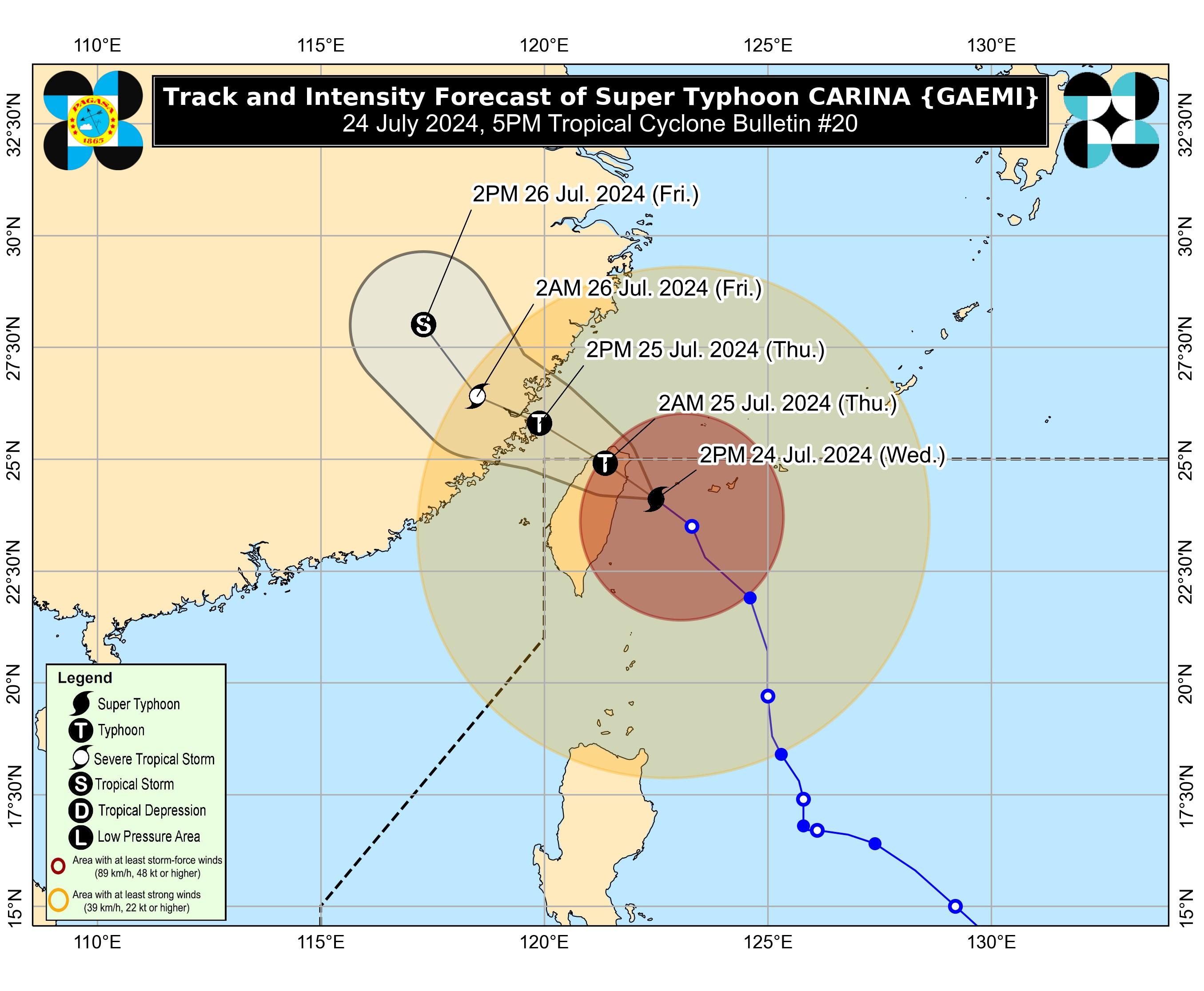
According to PAGASA's 5 p.m. cyclone bulletin, Super Typhoon Carina was last seen moving northwestward at 380 kms. north of Itbayat, Batanes at 20 kph.
Carina is expected to make landfall over the northern Taiwan on Wednesday evening, PAGASA said, and cross its "rugged terrain." The weather bureau said Carina will likely exit the PAR, which includes Taiwan, by Thursday morning.
PAGASA said Carina "has reached its peak intensity as Super Typhoon prior to its landfall over Taiwan due to favorable environment. Its landfall over northern Taiwan will trigger a weakening trend for the rest of the forecast period."
Carina packed maximum sustained winds of 185 kph, gusts of up to 230 kph, and strong to typhoon-force winds extending outwards up to 700 kilometers from the center.
Batanes remained under Tropical Cyclone Wind Signal (TCWS) No. 2, and may expect gale-force winds of 62 to 88 kph over the next 24 hours.
Minor to moderate threat to life and property may occur in affected areas.
The following areas under Signal No. 1 may experience strong winds of 39 to 61 kph over the next 36 hours:
- Babuyan Islands
- Northern portion of mainland Cagayan (Claveria, Santa Praxedes, Sanchez-Mira, Pamplona, Abulug, Ballesteros, Aparri, Camalaniugan, Buguey, Santa Teresita, Santa Ana, Gonzaga)
- Northern portion of Ilocos Norte (Burgos, Bangui, Pagudpud, Dumalneg, Adams)
Affected residents in these areas may expect minimal to minor threat to life and property.
Meanwhile, 50 to 100 mm of heavy rainfall may be observed in Batanes and Babuyan Islands from Wednesday to Thursday afternoon.
The southwest monsoon or Habagat, enhanced by the super typhoon, will bring moderate to intense rainfall over the western parts of Luzon until Friday, and strong to gale-force gusts over the following areas within the next few days:
- Wednesday: Ilocos Region, Cordillera Administrative Region, Nueva Vizcaya, Quirino, the eastern portion of Isabela, Central Luzon, Metro Manila, CALABARZON, MIMAROPA, Bicol Region, Visayas, Zamboanga Peninsula, Northern Mindanao, BARMM, and Davao Region
- Thursday: Ilocos Region, Cordillera Administrative Region, Nueva Vizcaya, Quirino, the eastern portion of Isabela, Central Luzon, Metro Manila, CALABARZON, MIMAROPA, Bicol Region, Western Visayas, Negros Occidental, and Northern Samar
- Friday: Ilocos Region, Cordillera Administrative Region, Nueva Vizcaya, Quirino, the eastern portion of Isabela, Central Luzon, Metro Manila, CALABARZON, MIMAROPA, Bicol Region, and Western Visayas.
A gale warning has also been placed over the coastal waters of Batanes, Babuyan Islands, and the northern portion of Ilocos Norte and Cagayan.
The effects of both Super Typhoon Carina and the enhanced southwest monsoon will cause rough seas over the seaboards of Northern Luzon, the the western seaboard of Central Luzon over the next 24 hours.
The western seaboard of Southern Luzon and the eastern seaboards of Central and Southern Luzon will have moderate to rough seas, while the southern seaboard of Southern Luzon, the western and eastern seaboards of Visayas, and the eastern seaboard of Mindanao will experience moderate seas. — VDV, GMA Integrated News
