2 typhoons now in PHL Area of Responsibility, may enhance monsoon rains
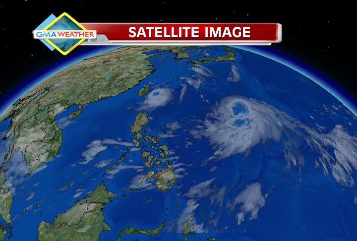
Two typhoons are now inside the Philippine Area of Responsibility (PAR) and their interaction may enhance the southwest monsoon over the weekend, state weather forecasters said Thursday. Having entered the PAR in the afternoon, typhoon Bolaven is now locally codenamed Julian.  Satellite image via Weather Central as of 6:30pm, showing the positions of Typhoon Igme (just above the Philippines, near Taiwan) and Typhoon Julian (international name: Bolaven, which entered the Philippine Area of Responsibility from the east around 2pm). As of 4:00 p.m. Thursday, PAGASA located Typhoon Julian at 1,200 km east of Basco, Batanes with maximum sustained winds of 140 kph near the center and gustiness of up to 170 kph. It is expected to move west-northwest at 11 kph. Meanwhile, the eye of Typhoon Igme was located at 245 north-northeast of Basco, Batanes, with maximum sustained winds of 130 kph near the center and gustiness of 160 kph. It is forecast to move west at 7kph. "Asahan din natin humahatak ito ng habagat, hindi lang si Igme ang hahatak ng habagat, pati si Bolaven," PAGASA forecaster Aldczar Aurelio said in an interview on dzBB radio. Fujiwhara Effect He said that since the two appeared to be equally strong, they may pull at each other and engage in a seesaw-like motion —the so-called "Fujiwhara Effect". "Parang seesaw sila. Pag si Julian nag-move northward, si Igme sa opposite direction," he said. For now, Aurelio said the chances of one typhoon absorbing the other or both typhoons merging does not seem likely. He said a merging may occur only when one of the two is significantly weaker than the other. "Pareho sila malakas. May merging kung ang isa sa kanila humina," he said. Storm signals PAGASA forecaster Julie Nimes said Signal No. 2 is hoisted over Batanes while Signal No. 1 is hoisted over Calayan and the Babuyan Islands. According to the bureau’s 5 p.m. weather bulletin, Batanes group of islands will experience stormy weather. Similarly, Calayan and Babuyan group of islands shall have rains with gusty winds, and coastal waters along this area are expected to be very rough. Nimes also said both Julian and Igme will affect the northern and western sections of Luzon. She said Metro Manila may expect cloudy skies with light rain showers for the next three days. Luzon and the eastern sections of Visayas and Mindanao will experience moderate to strong winds blowing from the southwest direction. The rest of the country shall have mostly cloudy skies with scattered rainshowers and thunderstorms. Nimes said Igme is expected to be 240 km north-northwest of Basco by Friday morning, and 260 km northwest of Basco Saturday morning. It may bring rainfall of 10 to 20 mm (moderate to heavy) from its 500-km diameter. As for Julian, Nimes said the new typhoon is expected to be 90 km east of Batanes by Friday afternoon, and 590 km northeast of Basco Sunday afternoon. It may bring 10 to 20 mm per hour of rainfall (moderate to heavy) from its 600-km diameter. — Shaira Panela/BM/TJD, GMA News


