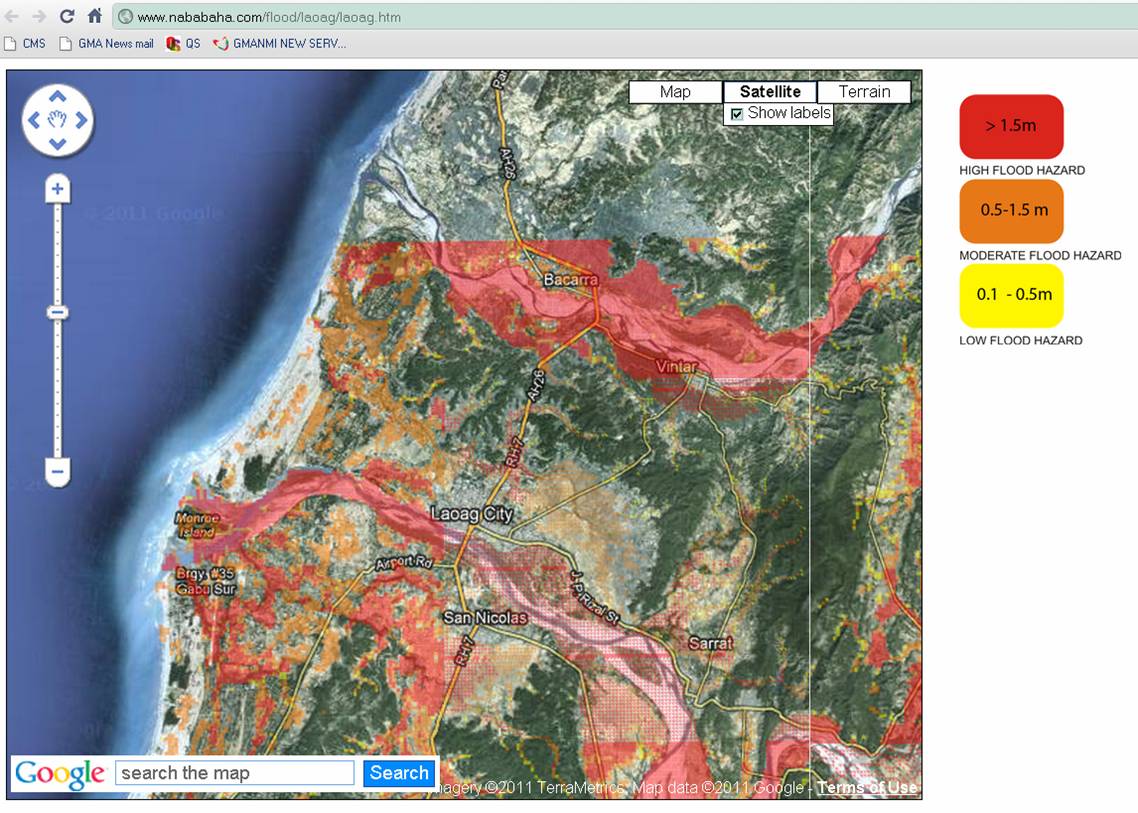
A geologist on Friday warned that other Philippine cities can suffer the same fate as devastated Iligan and Cagayan de Oro because of similarities in their topography. These include Vigan, Laoag, Alaminos (Pangasinan) and General Santos, which may be vulnerable to disastrous floods similar to those brought by Tropical Storms Sendong and Ondoy, according to the University of the Philippines’ National Institute of Geological Sciences (UP-NIGS). These cities sit on river deltas that flow out to sea. The web site Nababaha.com, maintained by UP-NIGS, contains flood hazard maps for these coastal zones that have rivers flowing right through them and are down slope from mountains and hills. For example, the inundation map for Vigan and the neighboring locales of Bantay, San Ildefonso and Santo Domingo shows many areas that could experience floods over 1.5 meters deep, according to UP Professor and NIGS director Mahar Lagmay told GMA News Online. Laoag City and neighboring Bacarra and Vintar have two waterways — Bislak and Padsan rivers — slicing through their terrain.

Simulated inundation hazard map of Laoag City and environs from www.nababaha.com shows high flooding risk.
Historically, those cities nababaha.com mapped are not prone to tropical storms as they are not in the usual typhoon path from the eastern side of the Philippines. Thus, like Iligan and Cagayan de Oro, these cities with little experience with storms don't have the preparedness mentality of residents in Albay, for example, who live in the shadow of the active Mayon Volcano in addition to the path of regular typhoons. Sendong is the wake-up call for vulnerable but complacent cities. Lagmay said these population centers at risk must adopt smart urban development plans to keep their residents out of harm’s way while allowing room for economic development.
“Ngayon lang nare-realize
ng local governments that we have to be smarter in dealing with the environment. Places like Iligan and other cities we have identified in nababaha.com must stop development in flood areas and implement proper zoning,” said Lagmay.

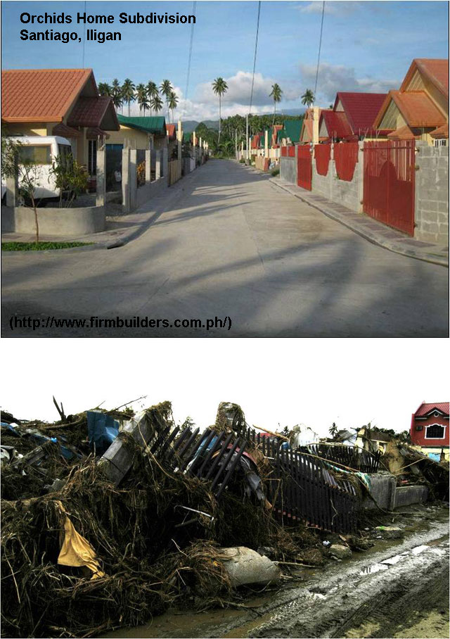
The destructive force of Sendong is reflected by these before and after images of a housing subdivision in Iligan City." Source: UP-NIGS
Other cities on the website are either along known paths of storms like those of Bicol and Eastern Visayas, or major rivers in Central Luzon and the Calabarzon provinces.
Simulated inundation maps Its flood hazard maps, according to nababaha.com, “are the products of flood simulations using Flo2d, a Federal Emergency Management Agency -approved flood routing application software. The inundation maps were simulated using rainfall delivered by tropical storm Ondoy on 26 September 2009…” “These hazard maps are indicative inundation maps for large flood events and useful only for knowing where not to be during extremely heavy rainfall,” the website noted. It urged local governments to use its hazard maps to determine evacuation and access routes, road closures, location of key rescue facilities, and for urban planning.
“Tsunamis with more debris” Tropical Storm Sendong that devastated part of Northern Mindano on Dec. 16 could have dumped the same amount of rainfall as “Ondoy” two years earlier, but the floods it triggered were definitely more massive and destructive. At a press conference Friday in Quezon City, Lagmay likened the Sendong-induced flashfloods to "tsunamis but with more debris." The UP-NIGS presented the progress report on the UP Pandayon’s Disaster Rescue Program — a survey of the disaster situation with a view to forging long-term solutions for storm-ravaged areas. "
Mas widespread at
mas high-velocity
talaga ang tumama sa Iligan. Iba ang dating," Lagmay said. That trees were uprooted and entire communities were swept away reflect the devastating floods of “Sendong,” he said. "
Kapag tumayo ka doon, akala mo flatland
lang, pero may barangay pala dati doon.” His observations were based on aerial and on-site inspections of Iligan City early this week. “The impact of this one was very heavy," Lagmay noted.
“Hyper-concentrated floods” The death toll from Ondoy wasmore than 400. Floods spawned by Sendong have killed more than 1,400 so far, with almost 400 of those killed coming from Iligan City. Ondoy's deluge in September 2009 brought record-level floods in Marikina City, Pasig City, and Rizal province. "
Ang sa Ondoy, umapaw lang ang tubig. Pero hindi mo makikita ang bahay na nagtutumbahan. Doon sa Iligan, kapag nilagay mo ang isang subdivision... wiped out
lahat iyon," he said. The geologist said that debris that came along with the rainfall contributed to speeding up the rush of the "hyper-concentrated floods" that hit Iligan City.
"Hindi lang siya tubig na rumaragasa. It contains a lot of sediments.
Kung may laman iyang sediments, then it's flowing when it comes in contact with anything it erodes it, and picks up more —
kasama na ang land, sediments, gravel and it becomes more masive," Lagmay said. "
Nagdo-double
ang volume
niya, sometimes one-is-to-two
ang ratio...
Habang bumababa, it incorporates more materials and sediments," he added.
— VS/HS, GMA News 


